Report on Kilauea (United States) — February 2004
Bulletin of the Global Volcanism Network, vol. 29, no. 2 (February 2004)
Managing Editor: Edward Venzke.
Kilauea (United States) Activity through April 2004 focuses in upper flow field (maps and diagrams)
Please cite this report as:
Global Volcanism Program, 2004. Report on Kilauea (United States) (Venzke, E., ed.). Bulletin of the Global Volcanism Network, 29:2. Smithsonian Institution. https://doi.org/10.5479/si.GVP.BGVN200402-332010
Kilauea
United States
19.421°N, 155.287°W; summit elev. 1222 m
All times are local (unless otherwise noted)
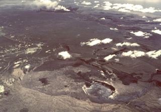
Kīlauea continued to be active at Pu`u `O`o during December 2003 through early March 2004. Figure 161 shows simplified maps and a diagrammatic cross-section on the Island of Hawaii, emphasizing local geography, and known and inferred conditions at Kīlauea. During the reporting interval observers noted incandescence and surface lava flows at Kīlauea's upper flow field. In general, surface lava flows were not seen on the coastal flat or Pulama pali. Various vents within Pu`u `O`o were active, and new lava flows covered parts of the crater floor. Seismicity at Kīlauea has generally included a few small earthquakes recorded at the volcano's summit, along with steady weak tremor. Tremor occurred continuously at moderate levels at Pu`u `O`o.
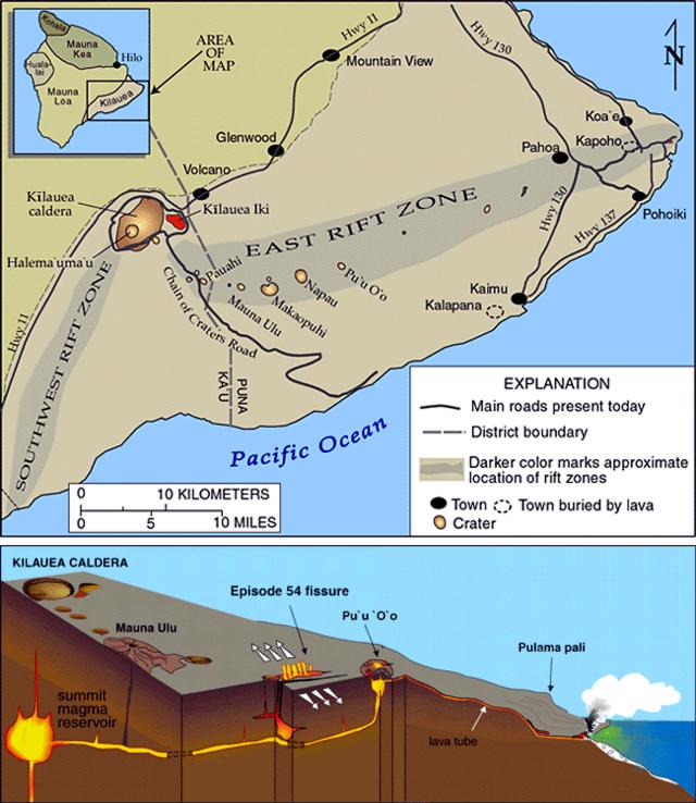 |
Figure 161. A map and cross-sectional diagram illustrating the island of Hawaii (the 'Big Island,' the largest and southernmost in the Hawaiian chain) showing selected volcanological features and some local geography. The inset shows how the island of Hawaii consists of five volcanoes (old to young): Kohala, Hualalai, Mauna Kea, Mauna Loa, and Kīlauea. The larger map emphasizes Kīlauea's features. Kīlauea is cut by two rift zones, the SW and E rift zones. The east rift zone extends 55 km from the summit caldera to the eastern tip of the Island of Hawaii. The E rift zone contains a string of craters, including Pu`u `O`o. The cross-sectional diagram displays a simplified model of Kīlauea's internal structure. Note the location of vents, at Pu`u `O`o and elsewhere, along the SW rift zone. The diagram also shows a lava tube running from Pu`u `O`o to the sea. The map and diagram both omit the details of recent eruptive events; for that, see later figures. Courtesy of the Hawaiian Volcano Observatory, U.S. Geological Survey. |
During 0550 to 0830 on 18 January 2004, a large period of tilt occurred at Kīlauea's Pu`u `O`o cone, amounting to 18.1 microradians of net deflation. During this period a fissure opened at the SE base of Pu`u `O`o, trending approximately radial to the cone. Lava was emitted from the fissure and from three to four vents nearby. The initial flow reached about 1.5 km S of the cone. The S side of Pu`u `O`o was cut by many new fractures. The longest fracture constituted the N boundary of a shallow graben (a linear trough bounded by faults) that was ~ 75 m long and up to 1 m deep. Surface lava flows were emitted from the E end of the graben, at the base of Pu`u `O`o. The area S of Pu`u `O`o cone appeared to be quite unstable, so Hawaiian Volcano Observatory (HVO) scientists warned that no one should venture into the area. Seismicity at Kīlauea's summit during 15-20 January was at low levels, while tremor at Pu`u `O`o was continuous and at moderate levels. The tremor picked up during the formation of the graben on 18 January. As of 20 January tilt continued to steadily decline following the 18 January deflation event.
On 22 January lava was emitted from the vent formed on 19 January. The vent and lava flow S of Pu`u `O`o cone were named MLK in honor of the activity that began on the American civil rights leader M.L. King Jr.'s birthday (19 January; see figures 162 and 163).
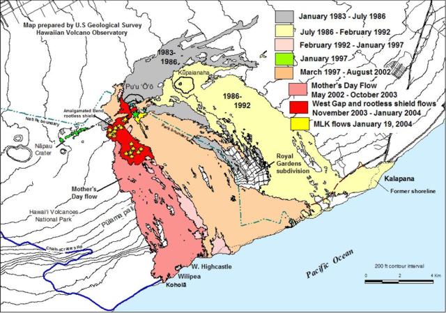 |
Figure 162. A sketch map showing Kīlauea's lava flows erupted during 1983-23 January 2004 activity of Pu`u `O`o and Kupaianaha. Lava flows began erupting from new MLK vent at the base of Pu`u `O`o (star) on 18 January 2004. Stars indicate centers of recently active, or still active, rootless shields in Mother's Day flow. New shields form often and not all shields appear on this map. Courtesy of the Hawaiian Volcano Observatory, U.S. Geological Survey. |
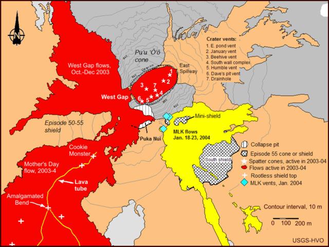 |
Figure 163. Sketch map of Pu`u `O`o region through 26 January 2004 identifying numerous vents, groups of lava flows, and other features referred to in this and previous issues of the Bulletin. Note the names assigned to intra-crater vents in the oval-shaped interior of Pu`u `O`o cone (stars 1-7) and the various rootless shields farther to the W. Courtesy of Hawaiian Volcano Observatory, U. S. Geological Survey. |
A term that has come into common use at Kīlauea is "rootless shield." Local geologists define this as a pile of lava flows built over a lava tube rather than over a conduit feeding magma from within the Earth. Rootless shields along the tube system commonly have flat tops containing shallow lava ponds. In the reporting interval, there were also surface lava flows at the W side of the rootless shield called Amalgamated Bend, a feature located SW of Pu`u `O`o (figure 6). By 26 January there were no surface lava flows at the MLK vent, and incandescence was only visible at the S part of the rootless shield complex. On 23 January moderate-to-strong tremor stopped beneath Kīlauea's caldera and lessened at Pu`u `O`o. On 26 January deflation that began on 18 January ended at Pu`u `O`o after reaching 24.7 microradians. This was probably the largest deflation event since early 1997.
During 29 January to 1 February mild volcanic activity occurred at Kīlauea, with incandescence visible at vents in Pu`u `O`o's crater and small surface flows on the central or southern part of the rootless shield complex. Starting on 18 January, when the MLK vent formed, the distance across the summit caldera decreased significantly, ending a period of increasing extension rate since the Mother's Day event in May 2002. During the report period, weak tremor occurred at Kīlauea's summit along with a few long-period earthquakes. Tremor at Pu`u `O`o remained moderate. During much of February 2004 and into early March, lava flows and incandescence were sometimes visible in Pu`u `O`o's crater and at the rootless shield complex (an area ~ 0.5 km SW of Pu`u `O`o). Weak background tremor occurred at Kīlauea's summit along with a few long-period earthquakes. Tremor at Pu`u `O`o was at moderate-to-low levels. Small deflation and inflation events occurred at the summit and at Pu`u `O`o.
Geological Summary. Kilauea overlaps the E flank of the massive Mauna Loa shield volcano in the island of Hawaii. Eruptions are prominent in Polynesian legends; written documentation since 1820 records frequent summit and flank lava flow eruptions interspersed with periods of long-term lava lake activity at Halemaumau crater in the summit caldera until 1924. The 3 x 5 km caldera was formed in several stages about 1,500 years ago and during the 18th century; eruptions have also originated from the lengthy East and Southwest rift zones, which extend to the ocean in both directions. About 90% of the surface of the basaltic shield volcano is formed of lava flows less than about 1,100 years old; 70% of the surface is younger than 600 years. The long-term eruption from the East rift zone between 1983 and 2018 produced lava flows covering more than 100 km2, destroyed hundreds of houses, and added new coastline.
Information Contacts: Hawaiian Volcano Observatory (HVO), U.S. Geological Survey, PO Box 51, Hawaii National Park, HI 96718, USA (URL: https://volcanoes.usgs.gov/observatories/hvo/).