Report on Cotopaxi (Ecuador) — November 2004
Bulletin of the Global Volcanism Network, vol. 29, no. 11 (November 2004)
Managing Editor: Richard Wunderman.
Cotopaxi (Ecuador) Seismically quiet in January-April 2004; planning for emergency water supplies
Please cite this report as:
Global Volcanism Program, 2004. Report on Cotopaxi (Ecuador) (Wunderman, R., ed.). Bulletin of the Global Volcanism Network, 29:11. Smithsonian Institution. https://doi.org/10.5479/si.GVP.BGVN200411-352050
Cotopaxi
Ecuador
0.677°S, 78.436°W; summit elev. 5911 m
All times are local (unless otherwise noted)
Seismicity at Cotopaxi during December 2003 through December 2004 yielded averages that generally remained within normal levels (table 3). Steam emissions continued, and sulfurous odors were occasionally reported. A plot of total seismicity each week during 2001-July 2004 portrayed numerous peaks and valleys in the range 50-200 events per week. Occasional excursions took the weekly totals to several hundred events in late 2001 and early 2002 (peaking at over 700 events per week during mid-October 2001). The 2004 data lacked such dramatic excursions.
Table 3. Annual summaries showing typical daily averages of various kinds of seismicity at Cotopaxi during 2001-2004. Courtesy of IG (shown on their website in the January 2005 report).
| Year | Volcano-tectonic | Hybrid | Long-period | Tornillo | Tremor | Total |
| 2001 | 3.1 | 1.0 | 10.2 | 0.1 | 0.2 | 11.3 |
| 2002 | 2.9 | 3.0 | 14.6 | 0.1 | 0.4 | 18.2 |
| 2003 | 1.2 | 3.7 | 9.3 | 0.0 | 1.4 | 14.2 |
| 2004 | 0.41 | 3.59 | 11.10 | 0.0 | 1.56 | 15.11 |
Planning for emergency water supplies. Although seismicity and other monitored parameters were moderate to low during most of 2003 (BGVN28:11 and 28:12), local authorities worked on a contingency plan for emergency drinking water in the event of a crisis at Cotopaxi.
The Quito metropolitan sanitation and drinking water company (EMAAP-Q) prepared a contingency plan for residents around Cotopaxi. The challenge was to provide for sufficient amounts of potable and sanitation water for some half a million people in the event of an eruption that contaminates their normal water supplies. This contingency plan was drawn up using experience gained from the operational emergency plan used to recover from the eruption in 1998-99 and the Reventador eruption in 2002.
During the Guagua Pichincha eruption, pyroclastic material impacted Quito, and ash fell into the water treatment plants and threatened the water supply systems. EMAAP-Q developed an operational and emergency plan. The plan was tested in 1999 when the volcano had two major eruptions that heat dropped ash on Quito and its infrastructure.
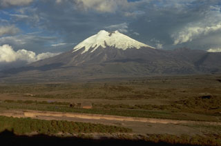
Geological Summary. The symmetrical, glacier-covered, Cotopaxi stratovolcano is Ecuador's most well-known volcano and one of its most active. The steep-sided cone is capped by nested summit craters, the largest of which is about 550 x 800 m in diameter. Deep valleys scoured by lahars radiate from the summit of the andesitic volcano, and large andesitic lava flows extend to its base. The modern edifice has been constructed since a major collapse sometime prior to about 5,000 years ago. Pyroclastic flows (often confused in historical accounts with lava flows) have accompanied many explosive eruptions, and lahars have frequently devastated adjacent valleys. Strong eruptions took place in 1744, 1768, and 1877. Pyroclastic flows descended all sides of the volcano in 1877, and lahars traveled more than 100 km into the Pacific Ocean and western Amazon basin. Smaller eruptions have been frequent since that time.
Information Contacts: Geophysical Institute (IG), Escuela Politécnica Nacional, Apartado 17-01-2759, Quito, Ecuador (URL: http://www.igepn.edu.ec/).