Report on Semeru (Indonesia) — March 2007
Bulletin of the Global Volcanism Network, vol. 32, no. 3 (March 2007)
Managing Editor: Richard Wunderman.
Semeru (Indonesia) Minor ash eruptions continue into February 2007
Please cite this report as:
Global Volcanism Program, 2007. Report on Semeru (Indonesia) (Wunderman, R., ed.). Bulletin of the Global Volcanism Network, 32:3. Smithsonian Institution. https://doi.org/10.5479/si.GVP.BGVN200703-263300
Semeru
Indonesia
8.108°S, 112.922°E; summit elev. 3657 m
All times are local (unless otherwise noted)
Our previous report (BGVN 29:06) covered activity at Semeru through 4 July 2004. This report, compiled chiefly from reports from the Center of Volcanology and Geological Hazard Management (CVGHM) and the Darwin Volcanic Ash Advisory Centre (Darwin VAAC), discusses subsequent activity into early 2007. Minor eruptions with the highest reported plumes reaching 7.6 km altitude continued from mid-2006 through April 2007. During mid-2006 to May 2007 there were also numerous thermal anomalies. The thermal data were captured by MODIS satellite sensors and presented on the MODVOLC system.
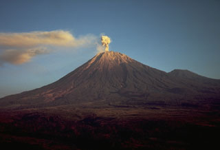
On 9 March 2006, the CVGHM reported "ash rain" fell in the vicinity of Semeru. An eruption associated with earthquakes was photographed on 31 October 2006 (figure 16). On April 22, based on information from a significant meteorological notice and satellite observations the Darwin VAAC reported the first of a series of eruptions. Plumes rose to an altitude of ~ 4 km. Table 17 summarizes reported ash plume eruptions at Semeru through February 2007.
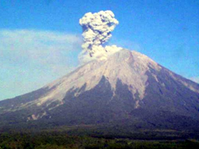 |
Figure 16. Photograph showing a Semeru ash explosion on 31 October 2006. Courtesy CVGHM. |
Table 17. Summary of reported ash plumes emitted from Semeru, July 2004 to February 2007. Courtesy of CVGHM and the Darwin VAAC.
| Date | Plume Height (km) | Plume Drift | Comments |
| 18 Jul 2004 | 3 | NW | pilot report |
| 5-10 Aug 2004 | 7.6 max | -- | pilot reports of ash clouds |
| 10 Aug 2004 | 6.1 | -- | ash plume |
| 24 Aug 2004 | -- | WSW | thin plume |
| 25 Aug 2004 | -- | WSW | thin plume, no ash visible |
| 21 May 2005 | 4.6 | S, then SSE | -- |
| 25 May 2005 | -- | -- | small plume reported by Darwin VAAC |
| 08-14 Mar 2006 | -- | -- | "ash rain" reported by CVGHM |
| 22 Apr 2006 | 4 | -- | based on significant meteorological notice, Darwin VAAC reported an eruption that generated plume (not visible on satellite imagery) |
| 10-16 May 2006 | 6.1 | -- | -- |
| 04 Jun 2006 | -- | -- | pilot reported multiple minor eruptions |
| 05-06 Jun 2006 | -- | -- | small ash plumes |
| 06, 12 Jun 2006 | -- | -- | small ash plumes |
| 11, 13 Jun 2006 | -- | -- | minor ash/steam plumes |
| 14 Jun 2006 | 6.1 | -- | pilot observation |
| 15, 17, 18 Jun 2006 | -- | -- | small ash plumes |
| 25 Jun 2006 | 5.5 | -- | -- |
| 29 Jun 2006 | -- | SE | -- |
| 10 Jul 2006 | 5.5 | -- | -- |
| 14 Jul 2006 | -- | SE | -- |
| 17 Jul 2006 | 4.3 | -- | -- |
| 18, 21, 24 Jul 2006 | 4.3 (max) | -- | -- |
| 24-25, 31 Jul 2006 | -- | -- | small plumes visible |
| 02 Aug 2006 | 5.2 | -- | -- |
| 25 Aug 2006 | -- | -- | ash plumes visible |
| 15 Sep 2006 | 4.3 | W | -- |
| 20-21 Sep 2006 | 11; 4.9 | SW | 90 km W |
| 18 Oct 2006 | 4.6 | -- | -- |
| 25-26 Oct 2006 | 7.6 | W | -- |
| 30 Oct 2006 | -- | -- | ash/steam emissions |
| 22 Nov 2006 | 7.6 | S | incandescent material fell in all directions within 200 m of plume |
| 24 Nov 2006 | 4.4 | -- | -- |
| 21 Dec 2006 | 4.3 | -- | -- |
| 10-11 Feb 2007 | -- | -- | ashfall 35 km E |
Geological Summary. Semeru, the highest volcano on Java, and one of its most active, lies at the southern end of a volcanic massif extending north to the Tengger caldera. The steep-sided volcano, also referred to as Mahameru (Great Mountain), rises above coastal plains to the south. Gunung Semeru was constructed south of the overlapping Ajek-ajek and Jambangan calderas. A line of lake-filled maars was constructed along a N-S trend cutting through the summit, and cinder cones and lava domes occupy the eastern and NE flanks. Summit topography is complicated by the shifting of craters from NW to SE. Frequent 19th and 20th century eruptions were dominated by small-to-moderate explosions from the summit crater, with occasional lava flows and larger explosive eruptions accompanied by pyroclastic flows that have reached the lower flanks of the volcano.
Information Contacts: Dali Ahmad, Hetty Triastuty, Nia Haerani, and Suswati, Center of Volcanology and Geological Hazard Mitigation (CVGHM), Jalan Diponegoro No. 57, Bandung 40122, Indonesia (URL: http://www.vsi.esdm.go.id/); Darwin Volcanic Ash Advisory Centre (VAAC), Bureau of Meteorology, Northern Territory Regional Office, PO Box 40050, Casuarina, NT 0811, Australia (URL: http://www.bom.gov.au/info/vaac/); Hawai'i Institute of Geophysics and Planetology (HIGP) Thermal Alerts System, School of Ocean and Earth Science and Technology (SOEST), University of Hawai'i, 2525 Correa Road, Honolulu, HI 96822, USA (URL: http://modis.higp.hawaii.edu/); Agence France-Presse.(AFP) (URL: http://www.afp.com/english/home/).