Report on Anatahan (United States) — December 2007
Bulletin of the Global Volcanism Network, vol. 32, no. 12 (December 2007)
Managing Editor: Richard Wunderman.
Anatahan (United States) During 2007-8 the crater lake dries up, continuing ash clouds
Please cite this report as:
Global Volcanism Program, 2007. Report on Anatahan (United States) (Wunderman, R., ed.). Bulletin of the Global Volcanism Network, 32:12. Smithsonian Institution. https://doi.org/10.5479/si.GVP.BGVN200712-284200
Anatahan
United States
16.35°N, 145.67°E; summit elev. 790 m
All times are local (unless otherwise noted)
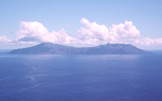
During mid 2007 and into early February 2008, Anatahan (figure 30) discharged occasional significant plumes, as restless seismicity associated with intermittent eruptions continued. Key source data for this report came from the U.S. Geological Survey (USGS), the Emergency Management Office of the Commonwealth of the Northern Mariana Islands (EMO), NASA Earth Observatory, and the Washington Volcanic Ash Advisory Center (VAAC).
 |
Figure 30. Satellite image of Anatahan in early 2008. Bright white areas are clouds. A diffuse plume dirfting NW appears to be originating from fumaroles in the eastern crater. Courtesy of Google Earth and Digital Globe, accessed 20 February 2008. |
The same day MODIS acquired this image, the U.S. Air Force Weather Agency reported an odor of sulfur on the island of Guam, ~ 200 km SW of Saipan, which also suggests the presence of vog. USGS and EMO air quality instruments on Saipan recorded a maximum 5-minute average of 959 ppb sulfur dioxide (SO2) and 99 ppb hydrogen sulfide (H2S) on 18 March. Although such plumes can cause closure of the Saipan airport and result in health risks to Saipan residents, such problems were not mentioned in reports of this incident.
Crater lake disappears. Seismicity remained restless and intermittent plumes continued to discharge from Anatahan during late 2007 and into 2008. By 31 January 2008 the crater lake had disappeared.
Distinct increases in amplitude of seismic tremors occurred on 26 and 28 November 2007. Explosions were also observed, with rates peaking on 28 November at several per minute. This increase prompted raising the alert level to Yellow/Advisory on 29 November.
On 14 December 2007 the Washington Volcanic Ash Advisory Center (VAAC) reported a steam plume visible in satellite data, but no indication of ash. There was a small surge in seismic activity recorded on 16 December that decreased to previous levels by the following day. According to the U.S. Air Force Weather Agency, a plume on 30 December consisted primarily of steam and gas, with little ash content. Seismic tremor levels increased 16 January 2008 and persisted.
On 31 January 2008, satellite data showed that the lake in the E crater, a water body whose level had been dropping since September 2007, had disappeared. According to the USGS, the tremor indicated that the volcano may have entered a new phase within its current episode of unrest, and the disappearance of the lake suggested that the magmatic heat source may have moved closer to the surface.
Ash emissions occurred at Anatahan on 3 February 2008. Satellite images showed a diffuse ash plume extending W for ~ 100 km. It was not possible to determine precisely the altitude of this ash plume from the currently available data, but it was likely less than 1,500 m. On 5 February, the USGS reported persistent elevated seismic tremor and continued detection of SO2 in satellite data. The USGS changed the Aviation Color Code to Orange and the Alert Level to Watch as a result of the ash emissions.
A satellite image (figure 31) shows the volcanic island on 6 February 2008. Dwarfed by clouds overhead, the island released a faint plume (presumably bearing little if any ash) blowing WNW. Data from the satellite-based Ozone Monitoring Instrument (OMI) showed a low-level SO2 plume extending W to SW from the volcano.
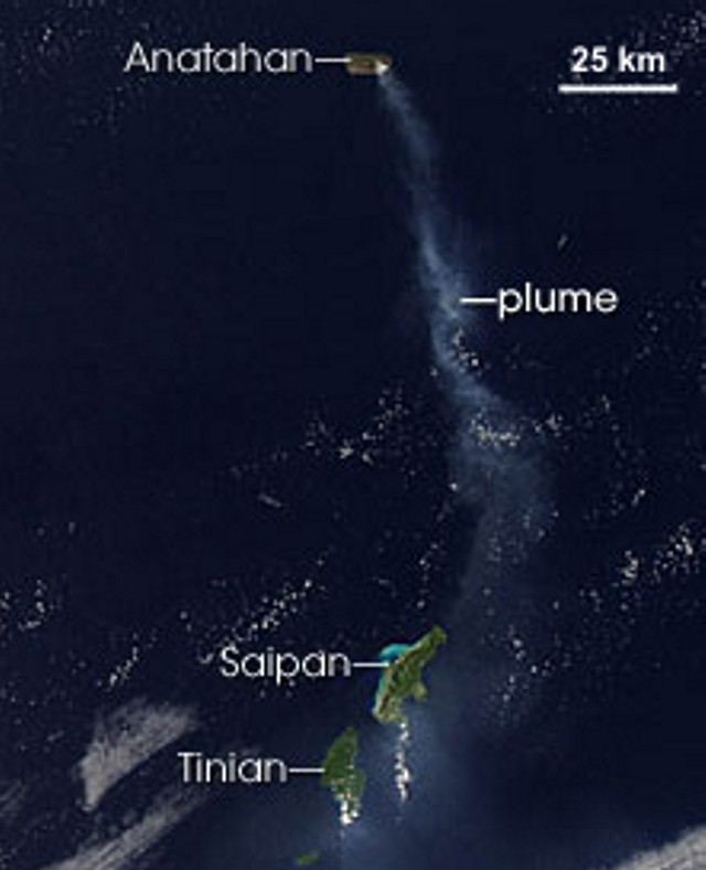 |
Figure 31. Anatahan released plumes of ash and steam in early February 2008, continuing a pattern of intermittent activity from the previous December. The Moderate Resolution Imaging Spectroradiometer (MODIS) on NASA's Aqua satellite captured this image on 6 February 2008. In this image, a diffuse pale gray plume blows W from the volcanic island and over the Pacific Ocean. NASA image courtesy the MODIS Rapid Response Team at NASA GSFC. |
No thermal anomalies have been measured by MODIS satellites over Anataham since June 2006. In a recent publication, Hilton and others (2007) reported on newly derived SO2 emission rates for Anatahan.
Reference. Hilton, D. R., Fischer, T. P., McGonigle, A. J. S., and de Moor, J. M., 2007, Variable SO2 emission rates for Anatahan volcano, the Commonwealth of the Northern Mariana Islands: Implications for deriving arc-wide volatile fluxes from erupting volcanoes: Geophysical Research Letters, v. 34, p. L14315, doi:10.1029/2007GL030405.
Geological Summary. The elongate, 9-km-long island of Anatahan in the central Mariana Islands consists of a large stratovolcano with a 2.3 x 5 km compound summit caldera. The larger western portion of the caldera is 2.3 x 3 km wide, and its western rim forms the island's high point. Ponded lava flows overlain by pyroclastic deposits fill the floor of the western caldera, whose SW side is cut by a fresh-looking smaller crater. The 2-km-wide eastern portion of the caldera contained a steep-walled inner crater whose floor prior to the 2003 eruption was only 68 m above sea level. A submarine cone, named NE Anatahan, rises to within 460 m of the sea surface on the NE flank, and numerous other submarine vents are found on the NE-to-SE flanks. Sparseness of vegetation on the most recent lava flows had indicated that they were of Holocene age, but the first historical eruption did not occur until May 2003, when a large explosive eruption took place forming a new crater inside the eastern caldera.
Information Contacts: Emergency Management Office of the Commonwealth of the Northern Mariana Islands (EMO-CNMI) and USGS Hawaii Volcano Observatory, PO Box 100007, Saipan, MP 96950, USA (URL: http://www.cnmihsem.gov.mp/ and https://volcanoes.usgs.gov/nmi/activity/); U.S. Air Force Weather Agency (AFWA)/XOGM, Offutt Air Force Base, NE 68113, USA; NASA Earth Observatory (URL: http://earthobservatory.nasa.gov/); Washington Volcanic Ash Advisory Center (VAAC), Satellite Analysis Branch (SAB), NOAA/NESDIS E/SP23, NOAA Science Center Room 401, 5200 Auth Road, Camp Springs, MD 20746, USA (URL: http://www.ospo.noaa.gov/Products/atmosphere/vaac/); Google Earth (URL: http://earth.google.com/).