Report on Kilauea (United States) — July 2018
Bulletin of the Global Volcanism Network, vol. 43, no. 7 (July 2018)
Managing Editor: Edward Venzke.
Edited by A. Elizabeth Crafford.
Kilauea (United States) Overflows of lava lake in Halema'uma'u crater; Pu'u 'O'o crater floor collapses 30 April 2018; inflation and increased seismicity
Please cite this report as:
Global Volcanism Program, 2018. Report on Kilauea (United States) (Crafford, A.E., and Venzke, E., eds.). Bulletin of the Global Volcanism Network, 43:7. Smithsonian Institution. https://doi.org/10.5479/si.GVP.BGVN201807-332010
Kilauea
United States
19.421°N, 155.287°W; summit elev. 1222 m
All times are local (unless otherwise noted)
Open lava lakes at the Kīlauea summit caldera along with a lava lake and flows from the East Rift Zone (ERZ) have been almost continuous since the current eruption began in 1983, and the rift zone has been intermittently active for at least two thousand years. The period from January-April 2018 included the ending of activity in one part of the ERZ and the beginning of a new episode. March 2018 marked the tenth year of the active lava lake inside the Overlook vent at Halema'uma'u. Information for this report comes primarily from the US Geological Survey's (USGS) Hawaiian Volcano Observatory (HVO) which provides daily reports, volcanic activity notices, and photo and video data.
At the end of 2017, the lava lake inside the Overlook vent at Halema'uma'u crater maintained the typical activity it had exhibited throughout the year, with a consistent lava circulation pattern, and occasional spattering events from hardened lava falling into the lake from the pit walls. The lake level rose and fell by a few meters over periods of hours to days, ending the year about 30 m below its level at the beginning of the year. Longer-term subsidence of the Pu'u 'O'o cone on the East Rift Zone was also apparent during 2017, although there was little change in the elevation of the lava pond inside the west pit area of the crater; occasional rockfalls triggered minor spattering. At the end of 2017 the East Rift Zone episode 61g surface lava flow activity persisted on the upper portions of the flow field near Pu'u 'O'o, on the pali, and in scattered areas along the coastal plain. Changes in the subsurface flow in lava tubes contributed to frequent changes to surface breakout locations. The lava flowing into the ocean at Kamokuna slowed and finally ended in November 2017.
During January-April 2018, the lava lake level inside the Overlook vent of Halema'uma'u crater rose and fell daily with alternating periods of inflation and deflation, with a gradual overall inflationary trend. Inflation intensified at the end of April, and the lake overflowed onto the floor of the crater during 21-27 April. The lake level had dropped several meters below the rim of the vent by the last day of the month. Activity of the episode 61g lava flow decreased gradually throughout the period. The flow remained active at the base of the pali and on the upper flow field through February, but activity tapered off on the coastal plain. By the end of March, only the upper flow field was still active. Notable inflationary tilt began at Pu'u 'O'o on 12 March 2018. Lava flowed out of vents on the main crater floor and also created a perched lava pond in the west pit. In mid-April HVO noted that the inflation resulted from increased pressurization of the magma under Pu'u 'O'o and in the past this had led to the formation of new vents and lava flows along the East Rift Zone. A marked increase in seismicity and ground deformation at Pu'u 'O'o on the afternoon of 30 April was followed by the collapse of the crater floor, dispersing red ash a significant distance around the cone. Following the collapse, HVO seismometers and tiltmeters recorded a substantial increase in seismic activity and deformation from Kīlauea's summit to an area about 10-16 km downrift (east) of Pu'u 'O'o which propagated eastward overnight along the Lower East Rift Zone (LERZ), marking the beginning of a major new eruptive phase.
Activity during January 2018. Consistent activity continued into January 2018 with few notable changes. The lava lake inside the Overlook vent at Halema'uma'u crater rose and fell by a few meters over hours and days; on the East Rift Zone the lava pond persisted at Pu'u 'O'o cone, and scattered breakouts from the episode 61g lava flow continued. Early on 19 January two earthquakes of magnitude 2.4 and 2.5 occurred on the lower East Rift Zone near Leilani Estates. Also on 19 January, a rockfall from the wall of Halema?uma?u crater plunged into the lava lake producing a short-lived explosion of spatter and wallrock that blanketed an area around the former visitor overlook. Debris fell as far as the Halema'uma'u parking lot (figure 312).
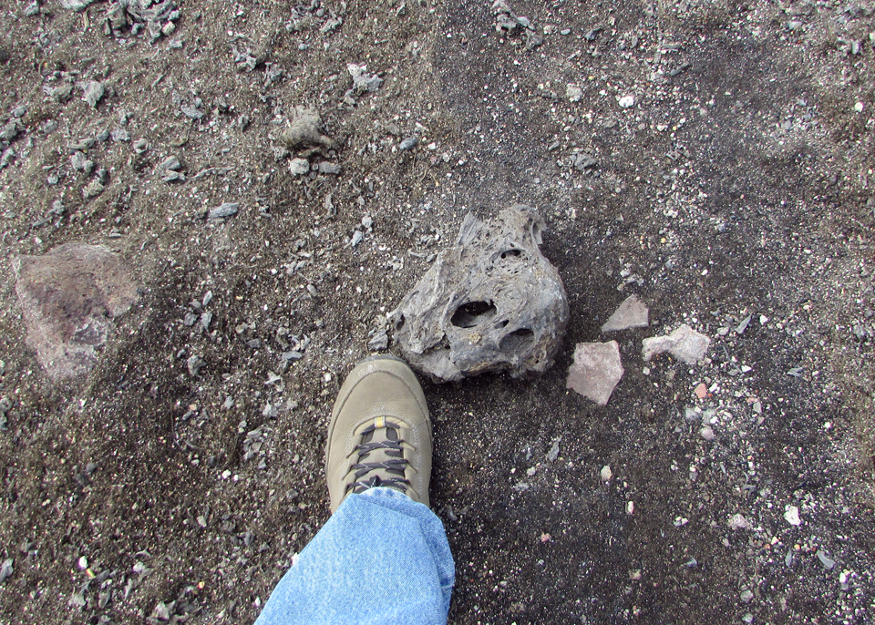 |
Figure 312. Spatter up to about 30 cm in size was thrown onto the rim of Halema'uma'u crater at Kīlauea during explosive events on 19 January 2018. Some fragments were thrown or blown farther downwind, reaching as far as the closed section of Crater Rim Drive in Hawai'i Volcanoes National Park. The boot of an HVO scientist, who entered the area to check on HVO's webcameras, is shown here for scale. Courtesy of HVO. |
HVO noted that spattering from the lava lake at Halema'uma'u was visible from the visitor overlook overnight during 25-26 January. Spatter appeared again briefly the next day, and overnight during 29-30 January. Four spattering sites were visible on a clear 30 January day (figure 313). Webcam views overnight on 30-31 January showed that incandescence persisted from the small lava pond on the W side of the Pu'u 'O'o crater. On the morning of 26 January a new breakout from the episode 61g flow appeared on the pali. By the end of January, most of the breakouts from the episode 61g flow field were concentrated at the base of the pali and on the upper flow field, with little activity on the coastal plain.
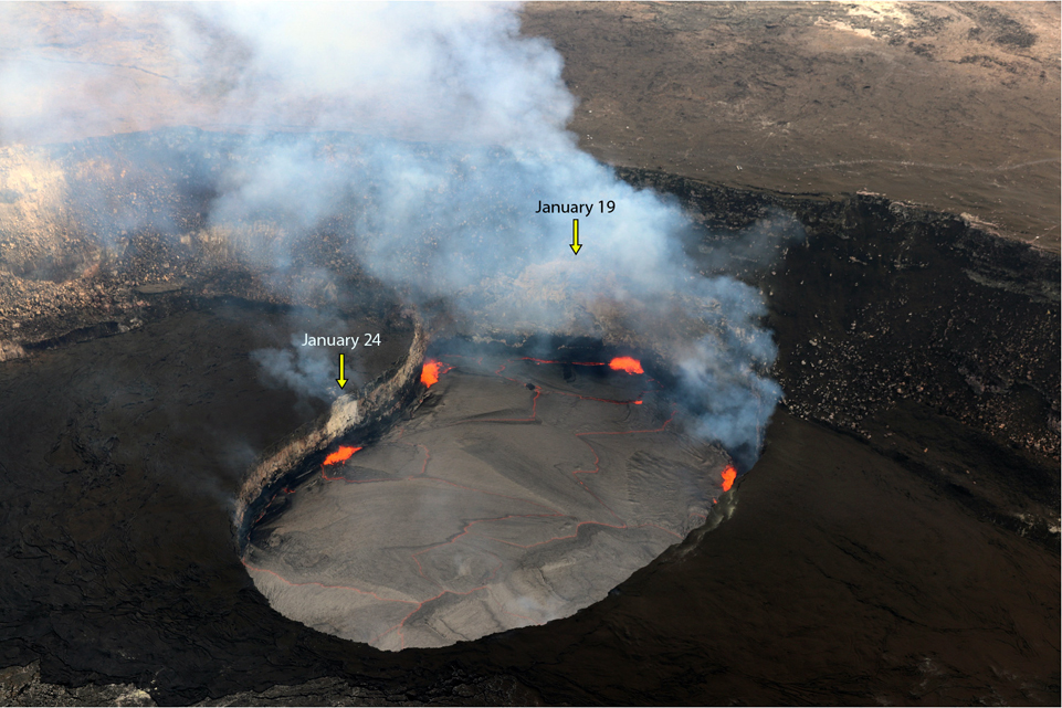 |
Figure 313. Clear views at the summit of Kīlauea on 30 January 2018 revealed four spattering sites visible on the surface of the Halema'uma'u lava lake inside the Overlook vent. Through the gas plume, a visible scar (light-colored wall rock) from the 19 January rockfall that triggered an explosive event, could be seen on the southern Overlook vent wall. Another, smaller scar on the northeastern lake wall (left), resulted from two small rock falls on 24 January. Courtesy of HVO. |
Activity during February 2018. The lake level inside the Overlook vent continued with daily fluctuations of several meters, between 31 and 42 m below the Halema'uma'u crater floor, during February 2018. A small veneer collapse (rockfall) into the lava lake on 23 February was visible in lava lake webcam images. Throughout the month, persistent incandescence was observed in the webcam at the Pu'u 'O'o west pit lava pond (figure 314). On 10 February a large portion of the NE rim of the west pit collapsed. Prior to and during the rim collapse, the adjacent ground also subsided. The episode 61g flow remained active at the base of the pali (figure 315) and in the upper flow field. A new breakout on the upper flow field, 1-2 km from the vent, appeared early on 26 February. A small swarm of earthquakes occurred in the upper East Rift Zone on 21 February; the largest event was a M 2.3. Seismicity throughout the volcano was otherwise at normal rates throughout the month.
 |
Figure 314. Incandescence from the west pit at Kīlauea's Pu'u 'O'o cone on 19 February 2018 was typical of that observed during clear weather throughout the month. Courtesy of HVO. |
 |
Figure 315. 'A'a flows at the base of Pulama pali at Kīlauea on 20 February 2018 produced shimmers of heat (top center) and incandescent fragments. Rubble from the flow rolled downhill, as the molten center slowly pushed forward. Courtesy of HVO. |
Activity during March 2018. A brief swarm of small earthquakes occurred in the upper East Rift Zone on 2 March 2018. An ongoing long-period earthquake swarm at 5-10 km depth beneath the caldera began late on 6 March and continued into the next day. At the Halema'uma'u crater, the lava lake fluctuated daily, with levels ranging from a low of 40.5 m below the crater floor to a high of 20 m below it. Changes in levels of up to 10 m in a 24-hour period were common. Vigorous spattering was observed on 6 March (figure 316). On 16 March, the lava lake rose high enough (26 m below the crater floor) for active spattering to be visible in webcams mounted in the HVO tower, located across the crater from the vent. The 10th anniversary of the eruption within Halema'uma'u crater was marked on 19 March. When the vent first opened on 19 March 2008, it formed a small pit about 35 m wide. Over the following decade, the pit (informally called the "Overlook crater") grew to about 280 x 200 m in size (see figure 313).
 |
Figure 316. Within Kīlauea volcano's summit lava lake at the Halema'uma'u crater, vigorous spattering on 6 March 2018 was occurring on the southern margin where a ledge of solidified lava had built out from the vent wall. Courtesy of HVO. |
Notable inflationary tilt at Pu'u 'O'o cone began on 12 March 2018; GPS stations also started recording extension across the cone on that date. A small increase in seismic events was observed at Pu'u 'O'o on the evening of 21 March. Increased views of spattering from the west pit lava pond were visible beginning the following day, likely due to subsidence over the previous months as reported by HVO. During the evening of 25 March lava flowed out of a vent in the SE part of the crater floor and continued to expand for the rest of the month (figure 317). Inflationary tilt slowed significantly on 27 March. Cracks along the ridge between the main crater and the west pit continued to grow throughout the month as the ridge continued to subside (figure 318).
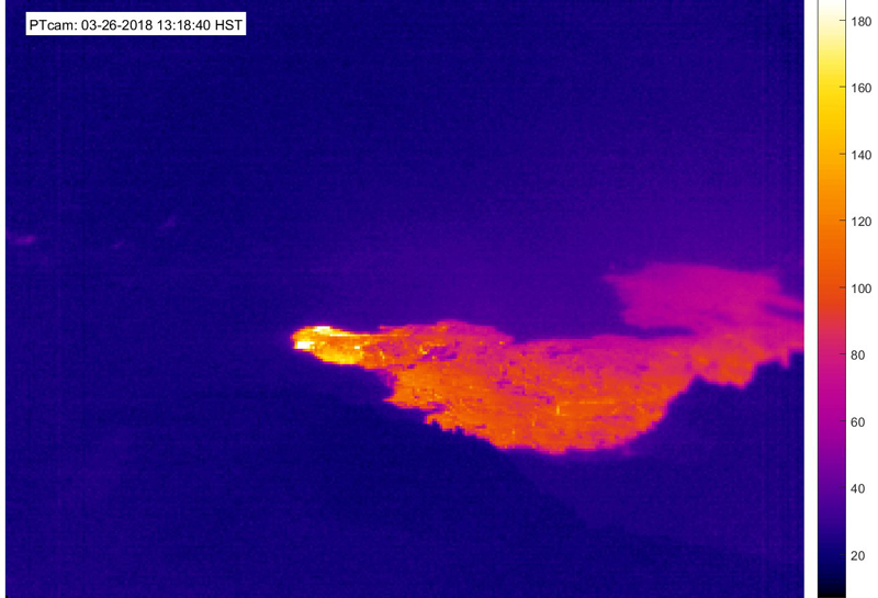 |
Figure 317. On 25 March 2018 a small lava flow began erupting onto the Pu'u 'O'o crater floor at Kīlauea for the first time since May 2016. In this thermal image, taken by the PTcam on 26 March 2018 at 1318, the flow (bright color) appears to be supplied by one of the small spatter cones in the crater's south embayment. The lava flow did not extend beyond the crater. This type of activity is not unusual for Pu'u 'O'o. Courtesy of HVO. |
 |
Figure 318. At Pu'u 'O'o on Kīlauea's East Rift Zone, the ridge separating the main crater (top) from the west pit (bottom) had been subsiding over the previous several months due to small rockfalls and unstable ground when this image was taken on 27 March 2018. As the ground shifted, cracks along the ridge and on both sides of it continued to open. The lava pond within the west pit rose several meters during March and produced overflows (darker lava) onto the floor of the pit as it rose. A small lava flow also erupted onto the floor of the main crater on 25 March and remained active through 27 March, visible as the lava darker in color in the foreground of the main crater floor. Courtesy of HVO. |
By 20 March surface lava flow activity from the episode 61g flow near the base of the pali appeared to have diminished, and only sparse lava flow activity on the coastal plains was noted after 23 March. Activity on the upper flow field, closer to Pu'u 'O'o, continued (figure 319). A 30 March overflight by HVO confirmed no flow activity on the coastal plain or the pali.
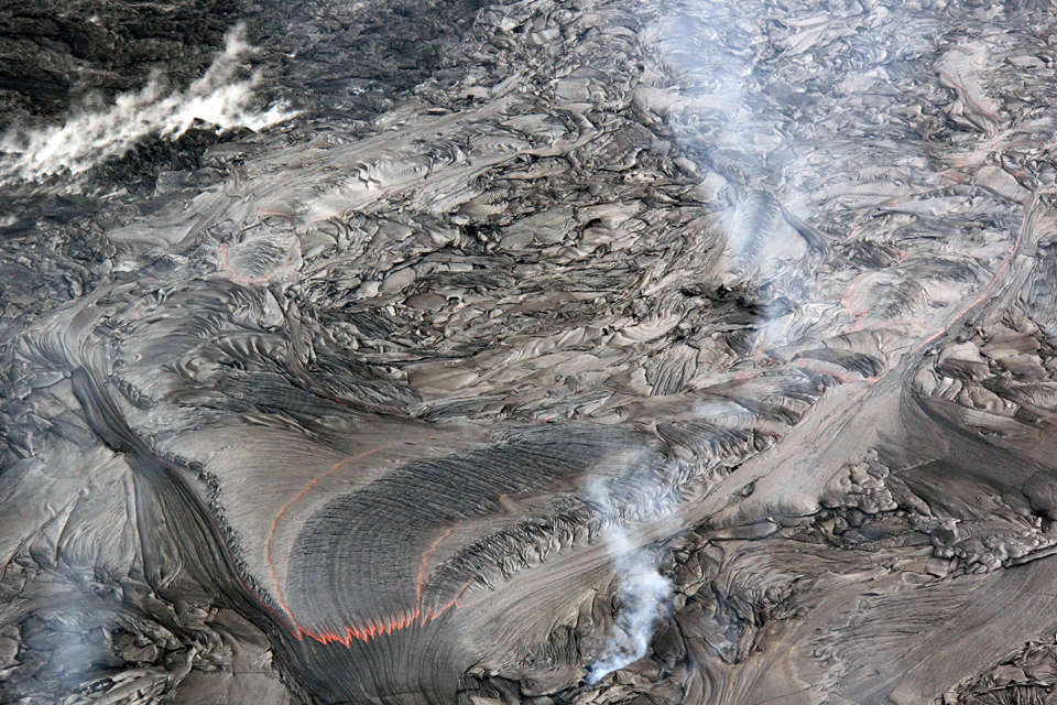 |
Figure 319. Active lava breakouts were scarce across the episode 61g flow field on Kīlauea's East Rift Zone, with active flows confined to an area approximately 1-2 km from Pu'u 'O'o during March 2018. This breakout from the lava tube consisted of fluid pahoehoe and was photographed on 27 March 2018 during an overflight. The incandescent area is several meters across. Courtesy of HVO. |
Activity during 1-16 April 2018. Constant spattering at the Overlook vent lava lake (figure 320) was intermittently visible from HVO and the Jagger Museum during April 2018 as the lake level rose and fell several meters on a daily basis. Its lowest level of the month was 32 m below the crater floor, and a general inflationary trend throughout the month resulted in significant overflows onto the floor of Halema'uma'u crater at the end of the month. A rockfall in the morning of 6 April triggered an explosion at the summit lava lake that damaged the power system to the Halema'uma'u crater rim webcams (figure 321). A moderate swarm of over 200 earthquakes occurred on 11 April at depths of 7-9 km below the summit; the largest event in the sequence was M 2.4. Seismicity returned to its background rate in the early morning of 12 April. Three minor ledge collapses, common while the lava lake level is lowering, occurred on 12 April.
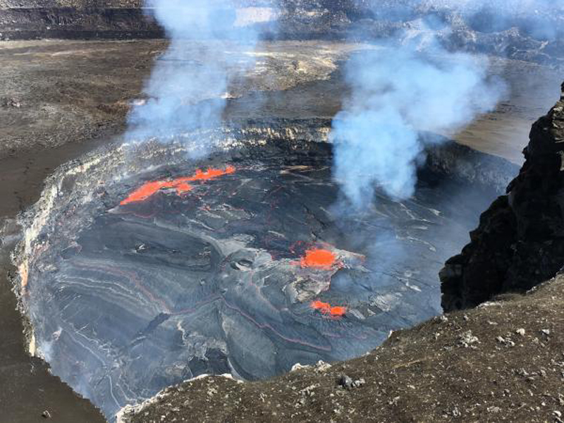 |
Figure 320. A clear view of Kīlauea's summit lava lake in the Overlook vent on 4 April 2018 revealed spattering on the N side and center of the lake surface, a departure from its more common location on the SE side of the lake; this occasionally happened when the surface flow direction reversed. Spattering is caused by gas bubbles bursting within the lava lake. Courtesy of HVO. |
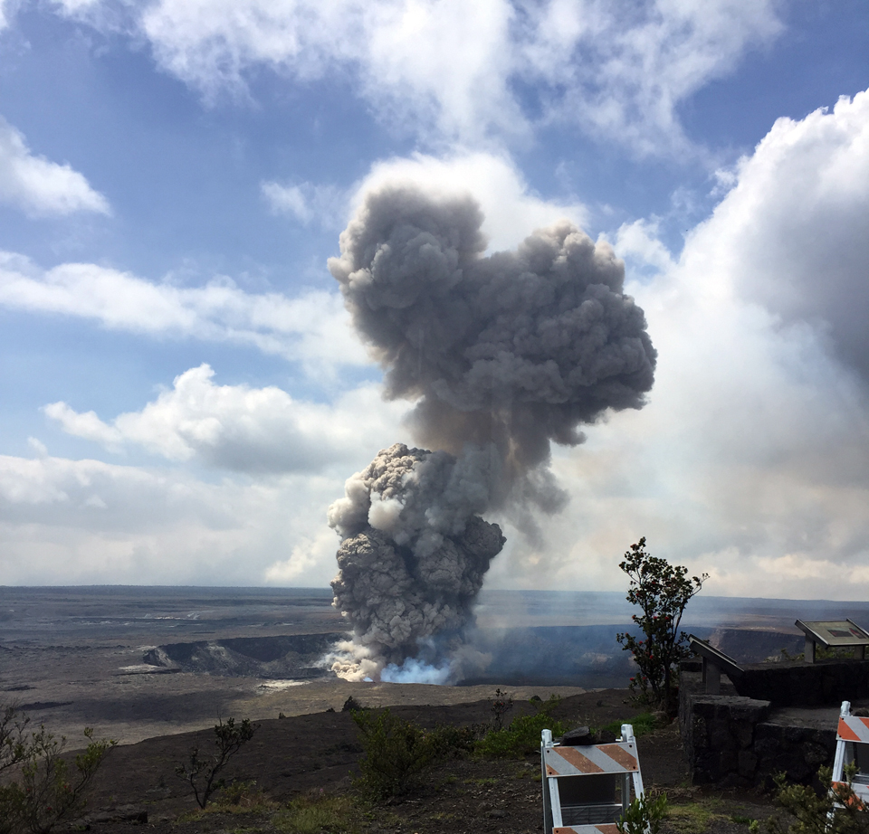 |
Figure 321. On 6 April 2018 at 1028 HST a partial collapse of the southern Overlook crater wall triggered an explosive event at Kīlauea's summit lava lake. A large plume of gas, ash, and lava fragments rose from the lava lake and was visible from the Jaggar overlook. The explosion threw debris onto the Halema'uma'u crater rim at the old visitor overlook, which has been closed due to ongoing volcanic hazards such as this explosive event. Courtesy of HVO. |
For the first half of April 2018, steady minor inflation continued at Pu'u 'O'o, interrupted by brief episodes of sharp deflation that appeared related to small lava flows on the crater floor. During an overflight on 13 April HVO geologists viewed a perched lava pond inside the west pit (figure 322). A slight increase in seismicity in the Upper East Rift Zone began overnight during 15-16 April; the largest event was a M 2.9 earthquake.
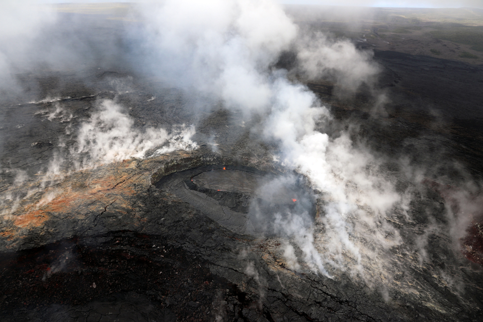 |
Figure 322. During an overflight of Kīlauea on 13 April 2018 geologists from HVO observed that lava within the west pit at Pu'u 'O'o had formed a perched lava pond (center) contained within a levee. This levee, formed by an accumulation of hardened lava, confined molten lava to the perched pond, which allowed the lava surface to rise higher than the west pit floor. If the pond rises high enough, lava can spill over the levee, forming small flows around the margin of the perched pond. Courtesy of HVO. |
At the beginning of April 2018 the episode 61g lava flow was active only above the Pulama pali. The areas of the upper flow field with active lava flows were located within the Kahauale'a Natural Area Reserve, which has been closed to the public since 2007 due to volcanic hazards. On 13 April 2018, geologists observed scattered breakouts from the 61g flow within about 2.2 km from Pu'u 'O'o and another sluggish breakout about 5 km from Pu'u 'O'o (figure 323).
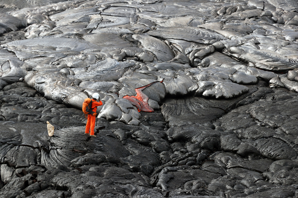 |
Figure 323. An HVO geologist photographed an active pahoehoe breakout on 13 April 2018 at Kīlauea after taking a lava sample nearby. This breakout was located approximately 0.4 km from the episode 61g vent. As the flow inflated, internal pressure cracked the rigid crust of the flow allowing molten lava to ooze out. Courtesy of HVO. |
Activity during 17-30 April 2018. Beginning in mid-April 2018 seismometers recorded an increase in the number of small earthquakes beneath the summit and upper East Rift Zone reflecting increased pressurization. Kīlauea's summit and East Rift Zone magma systems are connected, with changes at one sometimes leading to changes at the other. Tiltmeters, GPS, web cameras, and field observations, continued to record inflation at the Halema'uma'u crater, at Pu'u 'O'o, and at the upper portion of the episode 61g lava tube system. HVO noted that this inflation could lead to the opening of a new vent on or near Pu'u 'O'o that could cause a significant drop in the summit lake level.
At the Halema'uma'u crater, inflation significantly outpaced deflation for the second half of April. In the afternoon of 18 April the lake level was at 25 m below the crater floor. A lengthy episode of inflation brought the lava to within 6 m of the floor on the afternoon of 21 April. As the level continued to rise, a small overflow along the S crater rim occurred about midnight overnight on 21-22 April (figure 324). The lava lake was below the rim again the next morning but spilled out several times over the next several days to the N, S, and SW. The flows, similar to those produced during the last significant overflow event in April-May 2015, consisted of lobate sheets of shelly pahoehoe traveling as far as 375 m across the floor of Halema'uma'u. A small overflow had also occurred in October 2016.
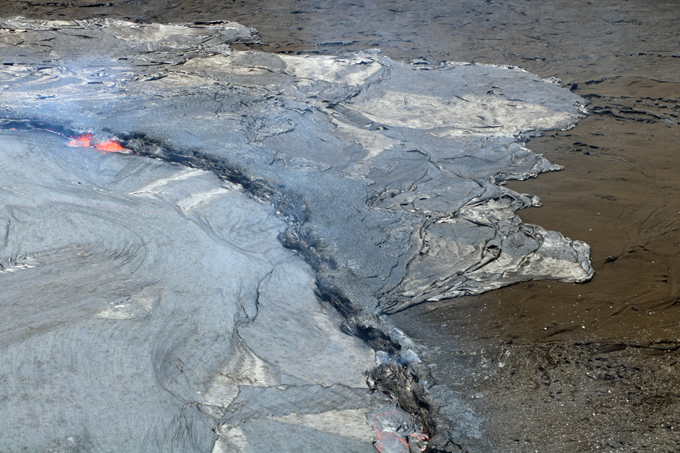 |
Figure 324. The rising summit lava lake levels first peaked overnight on 21-22 April 2018, producing small overflows onto the floor of Halema'uma'u Crater at Kīlauea. The largest overflow, on the N side of the Overlook vent (shown here), reached about 80 m from the lake margin. Image taken on 22 April 2018, courtesy of HVO. |
The summit lava lake spilled out of the Overlook crater rim multiple times during 22-27 April, caused by repeated inflation-deflation cycles (figures 325-327). Between overflows, the lava column receded below the crater rim. An overflight during the afternoon of 23 April showed that the overflows covered about 30% of the Halema'uma'u crater floor, approximately 16 ha. The height of the lava lake, on the floor of Halema'uma'u crater, was 79 m below the rim of the crater on 25 April. HVO estimated that only about one quarter of the floor of the crater remained uncovered by new flows as of 26 April. Summit tiltmeters continued to record an overall inflationary trend with brief periods of deflation until turning to more sustained deflation around midnight overnight on 26-27 April. A magnitude 3.2 earthquake occurred around 1308 HST on 26 April but did not cause any eruptive changes. Seismometers recorded a few small earthquakes in the upper East Rift Zone and south part of the caldera during 25-29 April.
 |
Figure 325. On 24 April 2018 between around 2030 and 2300, Kīlauea's summit lava lake overflowed again. The large overflow spread W (to the right) from the lava lake onto the floor of Halema'uma'u around 2230 in this image. The bright (yellow-white) spot is spattering along the S margin of the lava lake. USGS photo by M. Patrick, courtesy of HVO. |
 |
Figure 326. Beginning at approximately 0615 on 26 April 2018 a new overflow began covering about 36 hectares (90 acres) of Kīlauea's Halema'uma'u crater floor with lava, continuing for about four hours and covering about two-thirds of crater floor. This was the largest overflow since the summit eruption began in 2008. In this view to the S taken later in the day, the gas plume was being produced by the lava lake in the SE crater floor (upper left). Courtesy of HVO. |
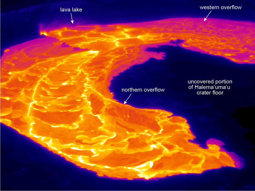 |
Figure 327. This thermal image (looking S) taken on 26 April 2018 at Kīlauea shows the active overflows from the lava lake (upper left) onto the Halema'uma'u crater floor. View is toward the south. Courtesy of HVO. |
The summit lake level dropped 16 m during 27-28 April, ending the period of inflation that produced the overflows onto the crater floor. The lake level remained about 15 m below the floor when skies cleared on 30 April and permitted a view from the webcam (figure 328). Slight inflation returned later in the day and the lake level rose to just beneath the vent rim.
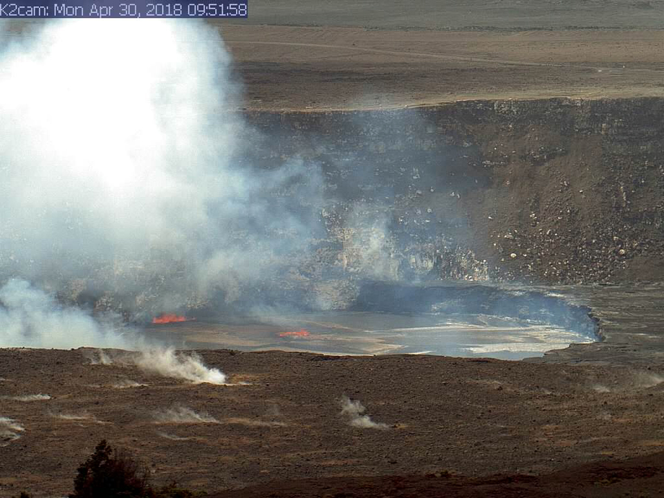 |
Figure 328. A break in the weather on the morning of 30 April 2018 allowed HVO's webcam to capture this image of the lava lake within Halema'uma'u at the summit of Kīlauea. Following multiple overflows of the lava lake the previous week, the lake level dropped after summit deflation. Early that morning, the lava lake level was estimated to be about 15 m below the vent rim, but shortly thereafter, the summit switched to inflation, and the lake level rose to just below the vent rim. Courtesy of HVO. |
HVO released a Volcanic Activity Notice, in addition to their regular daily report, midday on 17 April 2018. They noted that observations and measurements at Pu'u 'O'o during the previous month suggested that the magma system had become increasingly pressurized, raising the possibility that a new vent could form at any time, either on the Pu'u 'O'o cone or along adjacent areas. Since mid-March there had been uplift of the Pu'u 'O'o crater floor by several meters. Similar episodes of inflation and uplift at Pu'u 'O'o occurred in May-June 2014, prior to the start of the June 27th flow (active 2014-2016) and May 2016 before the start of the ongoing episode 61g flow.
When measured during a site visit on 18 April the pond level in the west pit at Pu'u 'O'o was 7 m higher than it had been in late March as a result of lava overflows building up the surrounding levee. An overflight on 23 April showed the perched lava pond with overflows slowly filling the pit (figure 329), and significant cracks on the NE part of the crater rim (figure 330). The pond had another overflow that remained in the pit on 24 April, and the floor continued to rise. Inflationary tilt continued at Pu'u 'O'o until it leveled off around midnight during 26-27 April, but the crater floor continued to rise for the next four days.
 |
Figure 329. On the East Rift Zone of Kīlauea, the perched lava pond in Pu'u 'O'o's west pit persisted during the second half of April, seen here on 23 April 2018. Overflows of the pond levees were slowly filling the bottom of the west pit and raising the floor. Courtesy of HVO. |
 |
Figure 330. Ongoing uplift of the crater floor of Pu'u 'O'o at Kīlauea beginning in mid-March 2018 generated numerous cracks on the crater floor and around the rim. These cracks cut through both recent lava flows (darker color) and older flows on the crater floor. Image taken on 23 April 2018, courtesy of HVO. |
Just after 1400 on 30 April 2018, a marked increase in seismicity and ground deformation began at Pu'u 'O'o. A few minutes later, a thermal webcam (PTcam) located on the crater rim showed the first of two episodes of floor collapse; the second collapse began at 1520 and lasted about an hour. Webcam views into the crater and surrounding area were frequently obscured by poor weather conditions. However, shortly after 1600 the PTcam recorded images that were likely the signature of small explosions from the western side of the crater as the floor collapsed.
Following the collapse there was an increase in seismicity and deformation from the summit to an area about 10-16 km downrift (east) of Pu'u 'O'o. Overnight, this activity continued to propagate eastward along the rift zone. The largest earthquake of this sequence was a magnitude 4.0 just offshore south of Pu'u 'O'o at 0239 on the morning of 1 May. HVO field crews were turned back the next morning by ash in the air above Pu'u 'O'o, likely due to continuing collapse within the crater and vigorous gas emissions. Reddish ash was also noted in abundance on the ground around Pu'u 'O'o.
Lava flow activity in the episode 61g flow continued on the upper flow field through the end of April 2018. Activity was focused above the pali and closer to Pu'u 'O'o, within 2 km of the vent. After the explosion and collapse of the crater floor at Pu'u 'O'o on 30 April, a large amount of red ash was deposited around the cone and covered over some of the active breakouts of the 61g flow (figure 331).
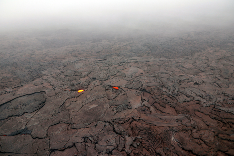 |
Figure 331. The collapse of the Pu'u 'O'o crater floor at Kīlauea on 30 April 2018 produced a large amount of red ash that was deposited around Pu'u 'O'o, as well as blown farther downwind, with a thin dusting of ash reaching uprift (west) as far as Mauna Ulu. On 1 May 2018, a layer of red ash covered active 61g lava flow surface breakouts in an area between 1-2 km from the 61g vent. Courtesy of HVO. |
Geological Summary. Kilauea overlaps the E flank of the massive Mauna Loa shield volcano in the island of Hawaii. Eruptions are prominent in Polynesian legends; written documentation since 1820 records frequent summit and flank lava flow eruptions interspersed with periods of long-term lava lake activity at Halemaumau crater in the summit caldera until 1924. The 3 x 5 km caldera was formed in several stages about 1,500 years ago and during the 18th century; eruptions have also originated from the lengthy East and Southwest rift zones, which extend to the ocean in both directions. About 90% of the surface of the basaltic shield volcano is formed of lava flows less than about 1,100 years old; 70% of the surface is younger than 600 years. The long-term eruption from the East rift zone between 1983 and 2018 produced lava flows covering more than 100 km2, destroyed hundreds of houses, and added new coastline.
Information Contacts: Hawaiian Volcano Observatory (HVO), U.S. Geological Survey, PO Box 51, Hawai'i National Park, HI 96718, USA (URL: http://hvo.wr.usgs.gov/).