Report on Dukono (Indonesia) — October 2020
Bulletin of the Global Volcanism Network, vol. 45, no. 10 (October 2020)
Managing Editor: Edward Venzke.
Edited by Kadie L. Bennis.
Dukono (Indonesia) Frequent gas-and-steam emissions, SO2 plumes, and ash plumes during April-September 2020
Please cite this report as:
Global Volcanism Program, 2020. Report on Dukono (Indonesia) (Bennis, K.L., and Venzke, E., eds.). Bulletin of the Global Volcanism Network, 45:10. Smithsonian Institution. https://doi.org/10.5479/si.GVP.BGVN202010-268010
Dukono
Indonesia
1.6992°N, 127.8783°E; summit elev. 1273 m
All times are local (unless otherwise noted)
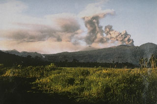
Dukono is one of Indonesia’s most active volcanoes and has been erupting continuously since 1933. Volcanism is primarily characterized by ash explosions and frequent ash plumes (BGVN 45:05). This report updates volcanic activity dominantly consisting of white and gray gas-and-steam emissions and ash plumes from April to September 2020, using primary information from the Pusat Vulkanologi dan Mitigasi Bencana Geologi (PVMBG, also known as Indonesian Center for Volcanology and Geological Hazard Mitigation, CVGHM), the Darwin Volcanic Ash Advisory Centre (VAAC), and satellite data.
Volcanism at Dukono during this period dominantly consisted of white and gray gas-and-steam emissions, accompanied by intermittent ash plumes that drifted in multiple directions. The ash plumes rose to 1.5-4.3 km altitude, or about 300-3,100 m above the summit, according to PVMBG and the Darwin VAAC advisories (table 22).
Table 22. Monthly summary of reported ash plumes from Dukono during April-September 2020. The direction of drift for the ash plumes was highly variable; notable plume drifts each month were only indicated in the table if at least two weekly reports were consistent. Data courtesy of PVMBG and the Darwin VAAC.
| Month | Plume altitude (km) | Notable Plume Drift |
| Apr 2020 | 1.8-2.4 | Multiple |
| May 2020 | 1.5-2.1 | E, NE |
| Jun 2020 | 1.8-2.4 | NW, SW, S, NNE, W |
| Jul 2020 | 1.8-2.4 | NW, W |
| Aug 2020 | 1.8-4.3 | Multiple |
| Sep 2020 | 1.8-2.7 | Multiple |
Activity during April was primarily characterized by white and gray gas-and-steam emissions, accompanied by intermittent ash plumes that rose 1.8-2.4 km altitude drifting in multiple directions (figure 15). Similar frequent gas-and-steam emissions continued into May, with ash plumes rising from 1.5 to 2.1 km altitude and drifting generally E, and NE, according to PVMBG VONA notices and the Darwin VAAC advisories. On 30 May six eruptions were observed, producing white and gray emissions 100-300 m above the crater.
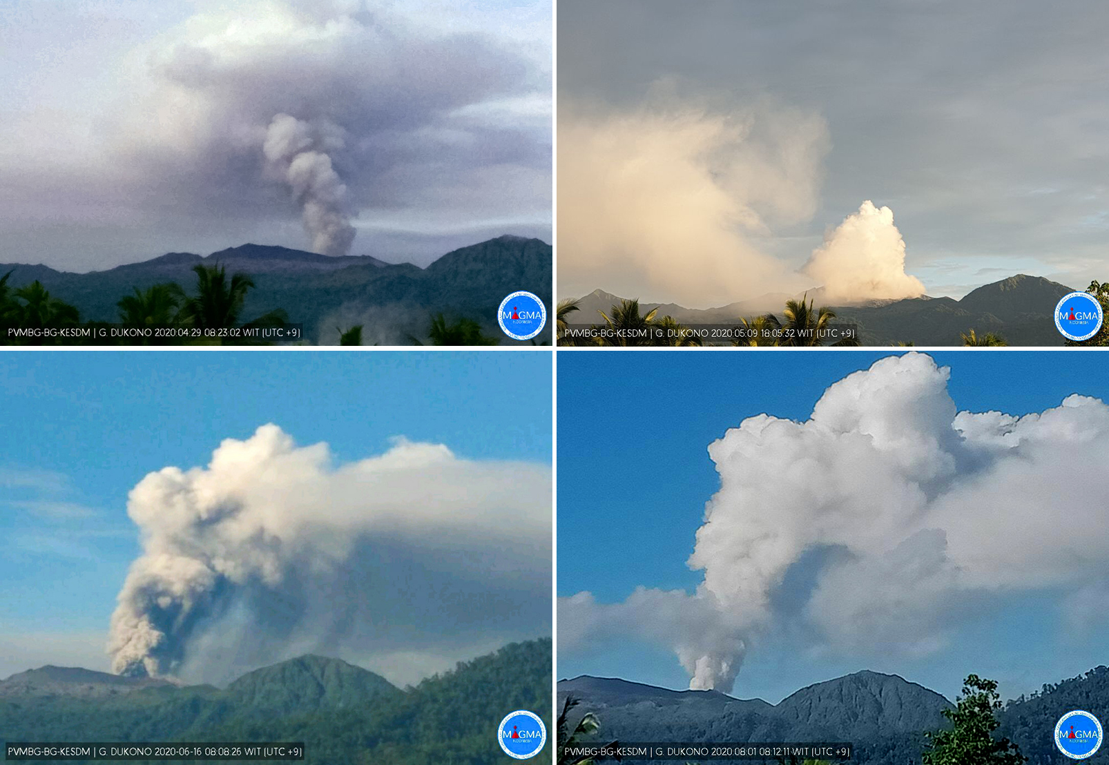 |
Figure 15. Webcam images of the frequent white and gray gas-and-steam plumes rising from Dukono on 29 April (top left), 9 May (top right), 16 June (bottom left), and 1 August (bottom right) 2020. Courtesy of MAGMA Indonesia. |
During June, the white and gray gas-and-steam emissions continued with the accompanying ash plumes rising to 1.8-2.4 km altitude and typically drifting NW, SW, S, NNE, and W. On 24 June a strong ash plume was observed in Sentinel-2 satellite imagery rising 2.1 km altitude and drifting NW and W, according to a Darwin VAAC notice (figure 16). Activity remained consistent in July, with ash plumes reaching 2.4 km altitude and drifting generally NW and W. On 11 July PVMBG reported that an eruption occurred at 0801; a second eruption was detected at 0806 on 12 July, which produced an ash plume roughly 700 m above the crater by 0949. On 31 July an eruption column was observed rising 500 m above the crater.
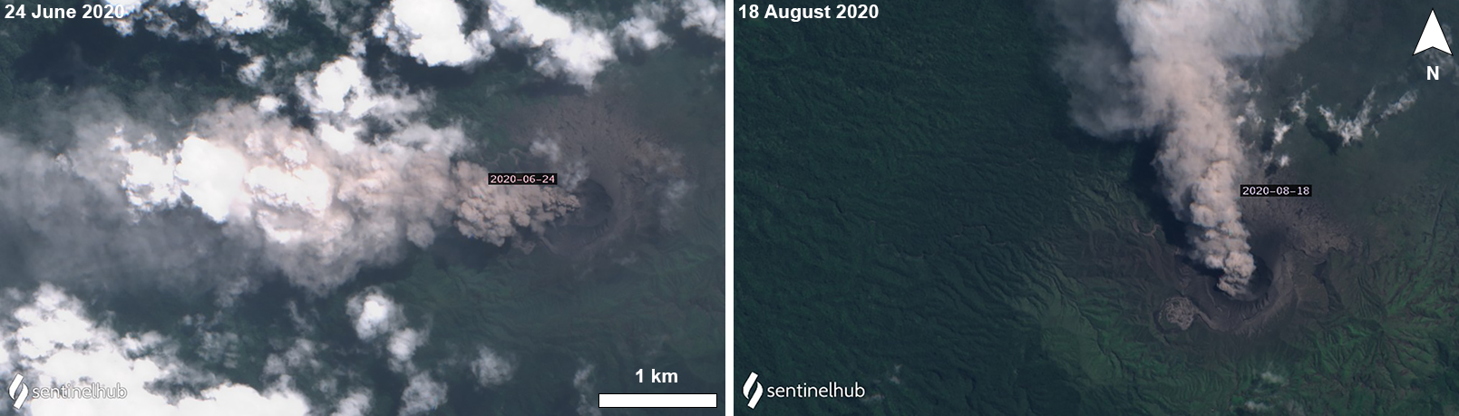 |
Figure 16. Sentinel-2 satellite images of a dense ash plume rising from Dukono and drifting W on 24 June (left) and N on 18 August (right) 2020. Images with “Natural color” rendering (bands 4, 3, 2); courtesy of Sentinel Hub Playground. |
In August, similar activity from the previous months persisted, with ash plumes rising now to 4.3 km altitude and drifting in multiple directions, according to the Darwin VAAC advisories. On 3 August an eruption column rose 500 m above the crater, and on 5 August an eruption was observed up to 400 m above the crater. PVMBG released a VONA report stating that an eruption on 7 August at 0817 produced an ash plume that rose 400 m above the crater drifting E. The Darwin VAAC issued an advisory on 17-18 August stating that a discrete ash plume rose to a maximum altitude of 4.3 km, drifting W and was associated with a summit thermal anomaly (figure 16). On 27 August an eruption plume was seen rising 600 m above the crater.
Activity in September was similar: white and gray gas-and-steam emissions remained consistent above the crater with intermittent ash plumes rising 1.8-2.7 km altitude and drifting in multiple directions. On 14 and 18-19 September an eruption produced ash plumes that rose 500 m above the crater.
The NASA Global Sulfur Dioxide page, using data from the TROPOMI instrument on the Sentinel-5P satellite, showed strong SO2 plumes rising from Dukono and drifting in various directions, though most often to the W (figure 17). These SO2 plumes were frequently detected during the reporting period, alongside occasional weak thermal anomalies in the summit crater, as observed in Sentinel-2 thermal satellite imagery (figure 18).
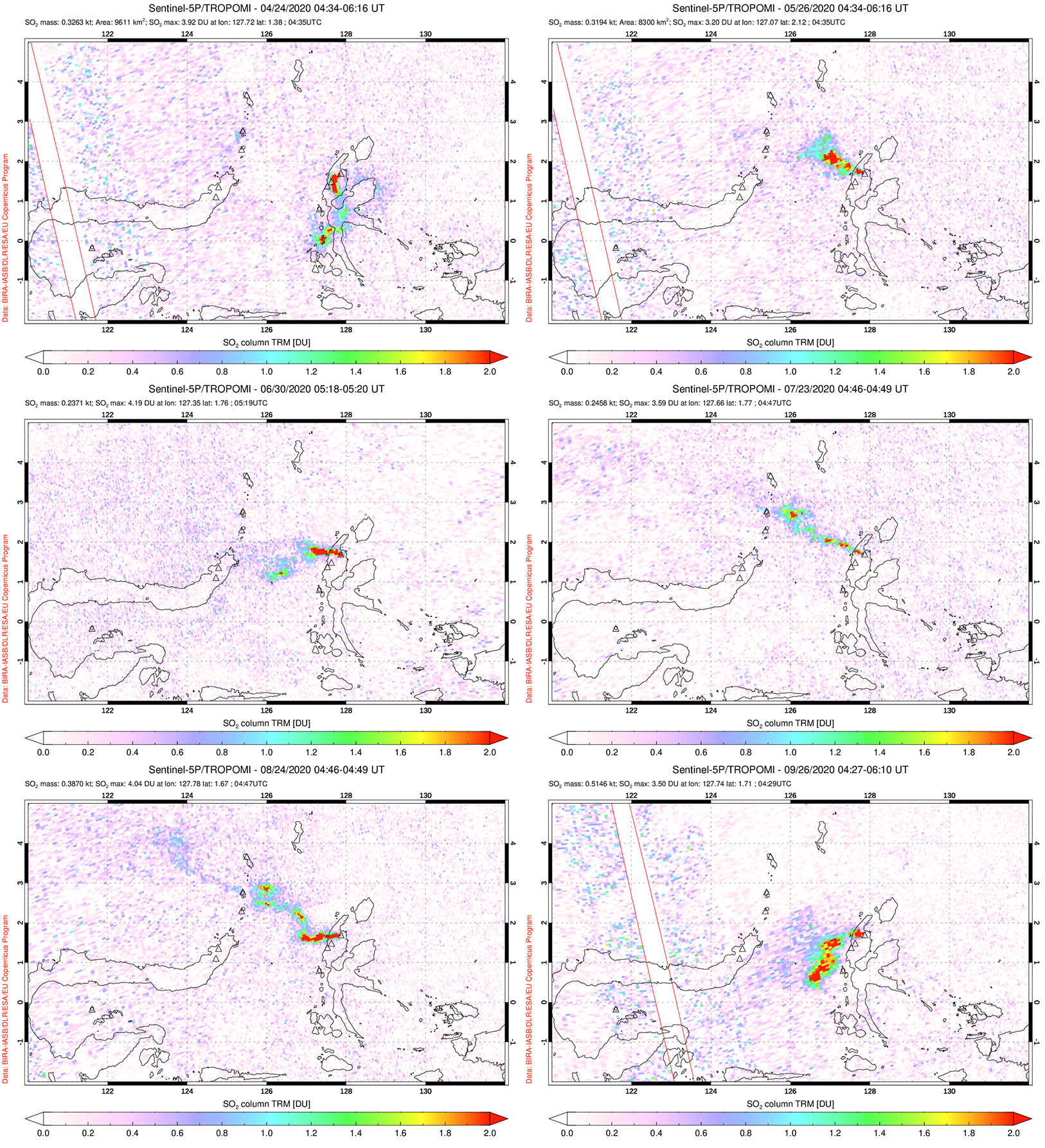 |
Figure 17. Strong sulfur dioxide emissions that rose from Dukono and drifted in multiple directions were detected using the TROPOMI instrument on the Sentinel-5P satellite on 24 April (top left), 26 May (top right), 30 June (middle left), 23 July (middle right), 24 August (bottom left), and 26 September (bottom right) 2020. Courtesy of the NASA Global Sulfur Dioxide Monitoring Page. |
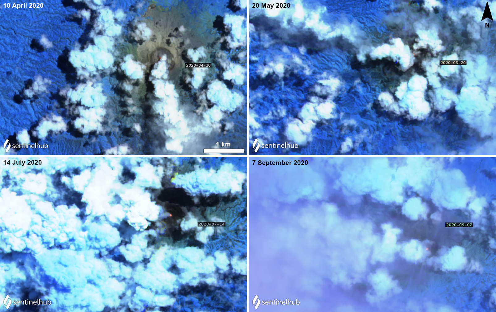 |
Figure 18. Sentinel-2 thermal satellite imagery of Dukono showing a weak thermal anomaly in the summit crater during April, May, July, and September 2020. Images with “Atmospheric penetration” (bands 12, 11, 8A) rendering; courtesy of Sentinel Hub Playground. |
Geological Summary. Reports from this remote volcano in northernmost Halmahera are rare, but Dukono has been one of Indonesia's most active volcanoes. More-or-less continuous explosive eruptions, sometimes accompanied by lava flows, have occurred since 1933. During a major eruption in 1550 CE, a lava flow filled in the strait between Halmahera and the N-flank Gunung Mamuya cone. This complex volcano presents a broad, low profile with multiple summit peaks and overlapping craters. Malupang Wariang, 1 km SW of the summit crater complex, contains a 700 x 570 m crater that has also been active during historical time.
Information Contacts: Pusat Vulkanologi dan Mitigasi Bencana Geologi (PVMBG, also known as Indonesian Center for Volcanology and Geological Hazard Mitigation, CVGHM), Jalan Diponegoro 57, Bandung 40122, Indonesia (URL: http://www.vsi.esdm.go.id/); MAGMA Indonesia, Kementerian Energi dan Sumber Daya Mineral (URL: https://magma.vsi.esdm.go.id/); Darwin Volcanic Ash Advisory Centre (VAAC), Bureau of Meteorology, Northern Territory Regional Office, PO Box 40050, Casuarina, NT 0811, Australia (URL: http://www.bom.gov.au/info/vaac/); Global Sulfur Dioxide Monitoring Page, Atmospheric Chemistry and Dynamics Laboratory, NASA Goddard Space Flight Center (NASA/GSFC), 8800 Greenbelt Road, Goddard, Maryland, USA (URL: https://so2.gsfc.nasa.gov/); Sentinel Hub Playground (URL: https://www.sentinel-hub.com/explore/sentinel-playground).