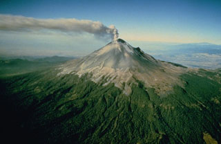
Popocatepetl
Mexico
19.023°N, 98.622°W; summit elev. 5393 m
All times are local (unless otherwise noted)
Volcán Popocatépetl is an active stratovolcano near Mexico City that has had frequent historical eruptions dating back to the 14th century. The current eruption has been ongoing since January 2005 and has more recently consisted of lava dome growth and destruction, frequent explosions, and emissions of ash plumes and incandescent ejecta. Activity through July 2020 was characterized by hundreds of daily low-intensity emissions that included gas-and-steam and small amounts of ash, and multiple daily minor and moderate explosions that sent ash plumes more than 1 km above the crater (BGVN 45:08). This report covers somewhat decreased activity from August 2020 through January 2021 using information from México's Centro Nacional de Prevención de Desastres (CENAPRED), the Washington Volcanic Ash Advisory Center (VAAC), and various satellite data.
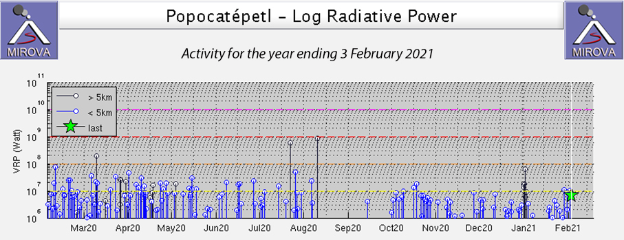
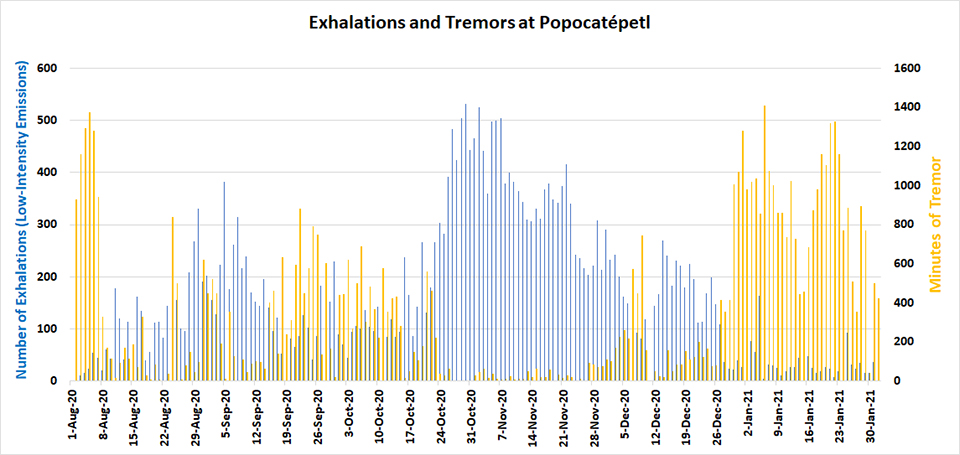
Popocatépetl had ongoing water vapor, gas, and ash emissions throughout August 2020-January 2021, but far fewer minor and moderate explosions than during the period of the previous report. Ash emissions generally rose to 5.8-7.1 km altitude and drifted in many different directions. Ashfall was reported in multiple communities during August, October, and numerous times in January 2021. Thermal anomalies were recorded in satellite images inside the summit crater a few times each month. The MIROVA thermal anomaly data indicated persistent, low levels of activity throughout the reporting period (figure 162). CENAPRED reported the number of low-intensity emissions or ‘exhalations’ and the number of minutes of tremor in their daily reports (figure 163). Tremor activity was very high at the beginning of August, and then again during January 2021. The daily number of exhalations was highest during late October and November 2020.
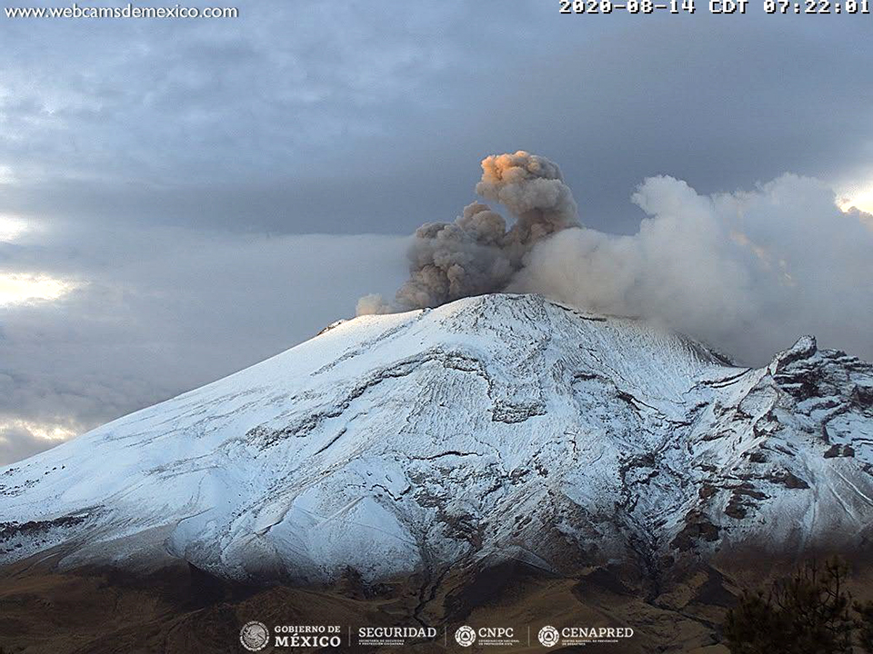
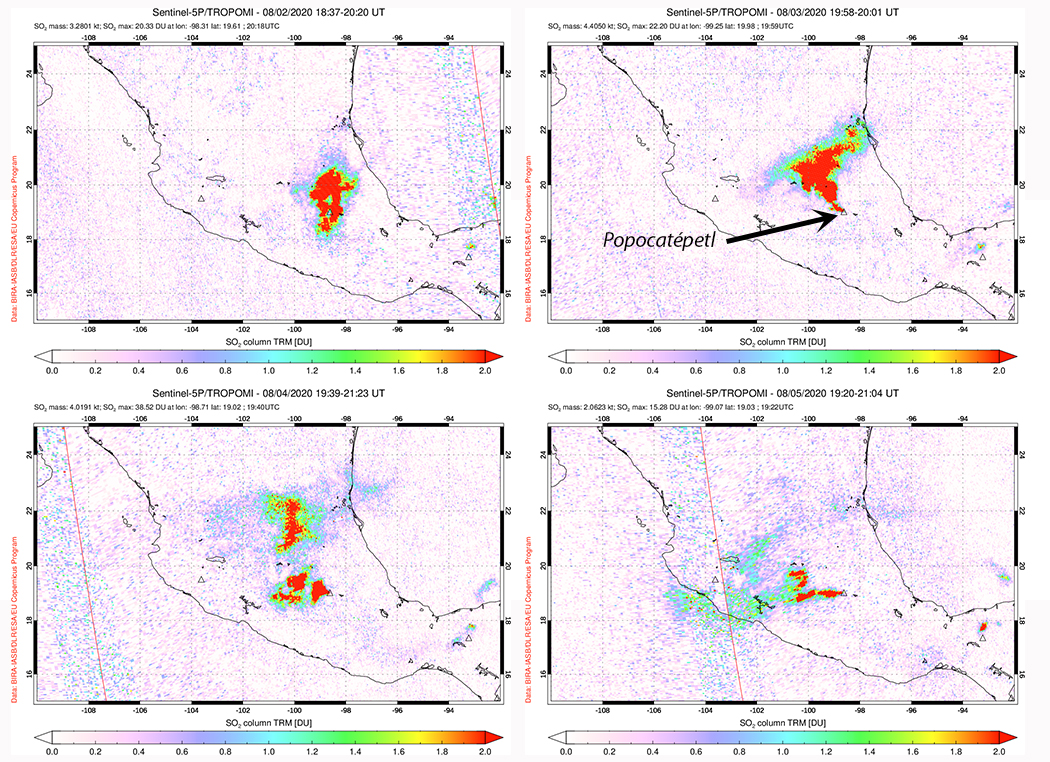
During August 2020 daily water vapor and gas emissions often contained small quantities of ash. In addition, low-intensity emissions or exhalations with larger quantities of ash occurred tens of times per day. The daily number of minutes of tremor was over 1,000 at the beginning of the month but dropped back to lower levels of a few tens or hundreds of minutes later in the month. Slight amounts of ashfall were reported in Amecameca and Ozumba in the State of Mexico on 1 August. On 2 August the 1159 minutes of tremor were sometimes accompanied by incandescent ejecta that fell into and a short distance from the summit crater. The Washington VAAC observed an ash emission drifting NE at 6.1 km altitude on 2 August that later rose to 7.6 km altitude. It fanned out from the summit to the N and E for about 15 km. Similar observations were made virtually every day of the month; ash or gas-and-ash emissions generally rose to 5.8-7.6 km altitude and drifted a few tens of kilometers in different directions before dissipating. Constant gas emissions and incandescence were reported at night during 10-23 August; an ash emission that rose to 600 m above the crater rim and drifted W on 14 August was captured in the webcam (figure 164). The largest SO2 emissions during the period were captured by the TROPOMI instrument on the Sentinel-5P satellite during 2-5 August (figure 165).
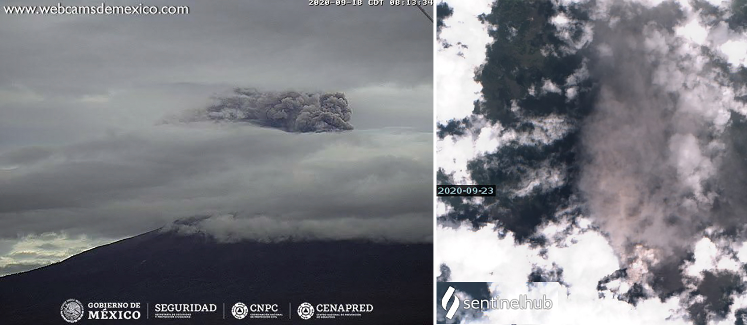
Gas and occasional weak ash emissions accompanied the tens of daily low-intensity emissions during September 2020; thermal activity was very low with weak anomalies inside the summit present in satellite images on 3, 8, and 13 September. Ash emissions were visible from a webcam on 18 September and in satellite imagery on 23 September (figure 166). Weak incandescence above the crater was only reported by CENAPRED during 26 and 27 September. The Washington VAAC reported intermittent ash emissions throughout the month that commonly rose to 6-7 km altitude and drifted over 50 km downwind before dissipating.
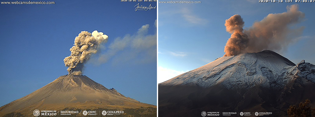
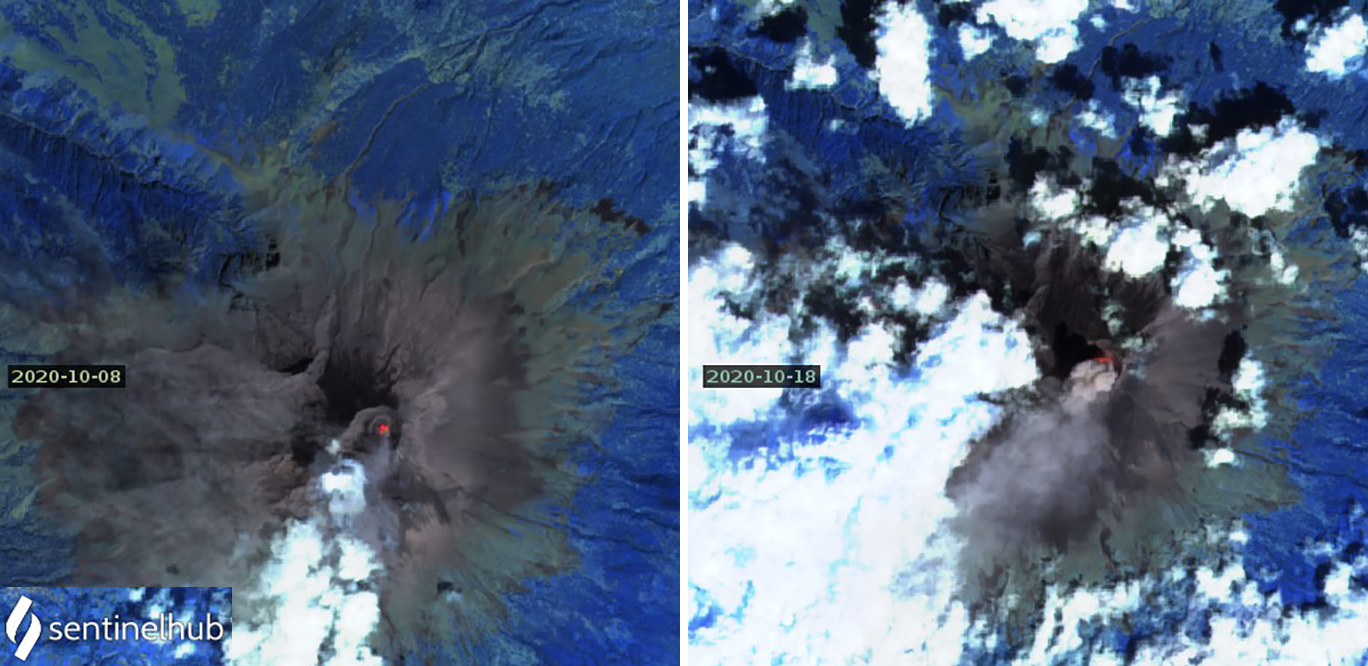
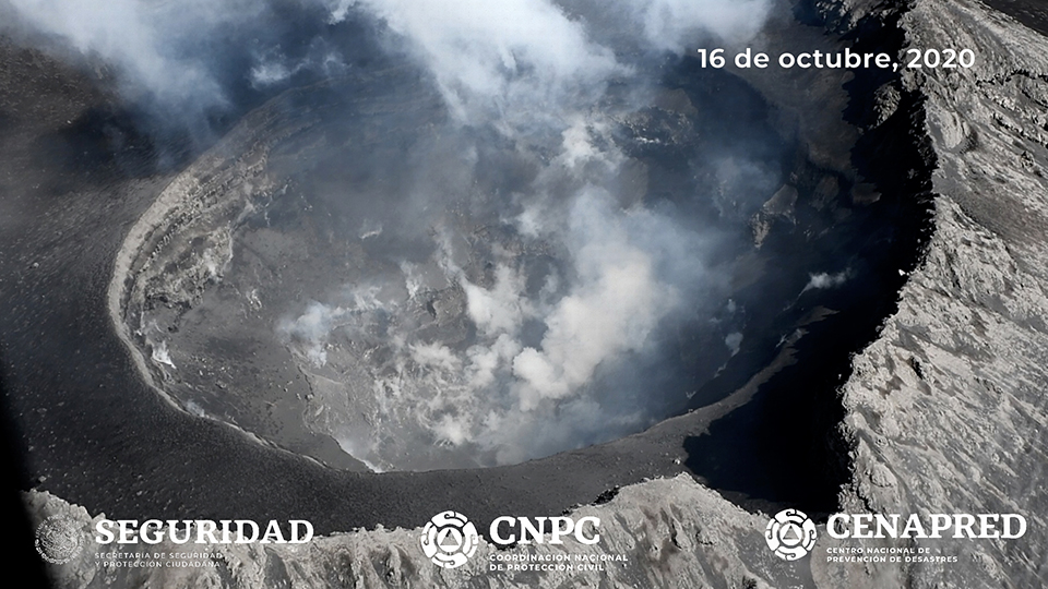
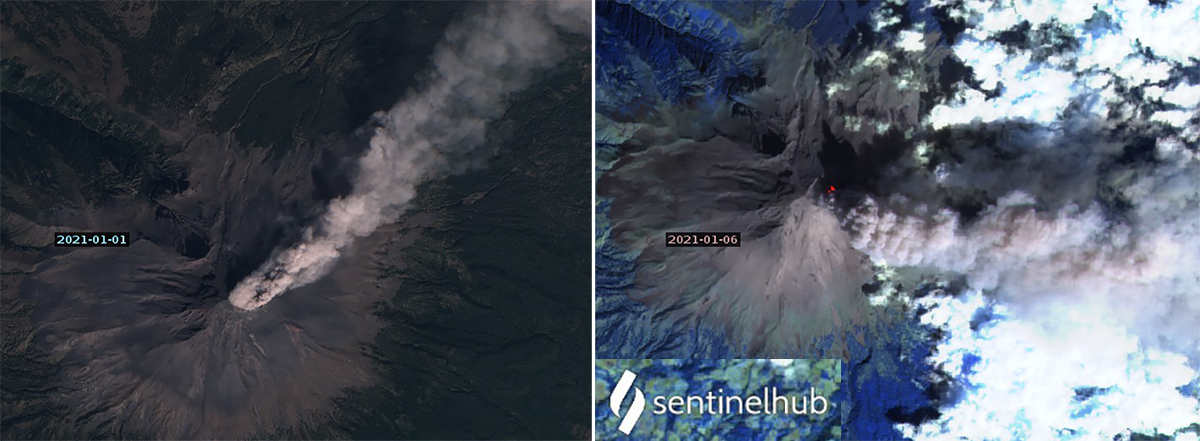
Water-vapor and gas emissions with small quantities of ash similar to those seen in September were also typical activity during October 2020. Tens or a few hundred daily low-intensity emissions often produced ash plumes visible in the webcams (figure 167). Ashfall was reported in Tetela del Volcano (20 km SW), in the state of Morelos, and in Amecameca (20 km NW), Atlautla (17 km W), Ayapango (22 km NW) and Ecatzingo (15 km SW), in the State of Mexico on 7 October; a small amount of ashfall was also reported in Amecameca on 13 October. The Washington VAAC issued multiple daily ash advisories throughout the month; many ash plumes were visible in satellite imagery. Incandescence appeared over the summit crater at night during 10-16 October, and was noted in satellite imagery on 3, 8, 18, 23, and 28 October. Incandescence and ash emissions were both captured in satellite imagery on 8 and 18 October (figure 168). Personnel from the Institute of Geophysics of the National Autonomous University of Mexico (UNAM) and the National Center for Disaster Prevention (CENAPRED) conducted an overflight on 16 October and verified that the inner crater at the summit was covered in tephra and about 360-390 m in diameter and 120-170 m deep (figure 169).
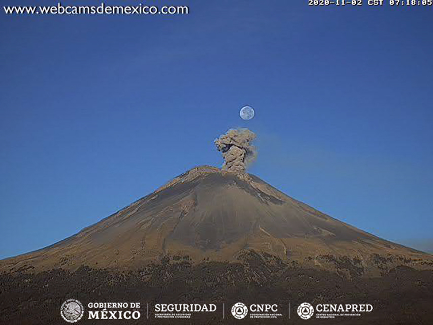
Activity during November 2020 consisted primarily of weak emissions of steam and gas with occasional small quantities of ash that rose a short distance above the summit crater (figure 170). The Washington VAAC reported ash emissions on 19 days during the month, most rising to 5.8-6.7 km altitude and drifting for a few tens of kilometers before dissipating. CENAPRED reported a few hundred low-intensity emissions daily, but only a few tens of minutes of tremor each day, significantly lower than previous months. Satellite imagery showed weak thermal anomalies inside the summit crater on 2, 7, 12, 22, and 27 November.
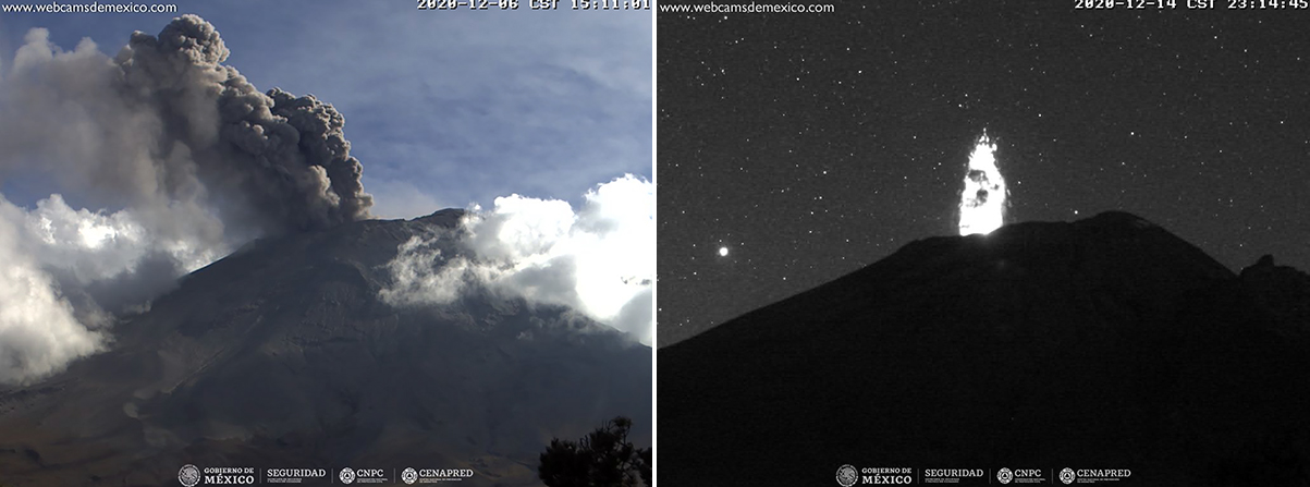
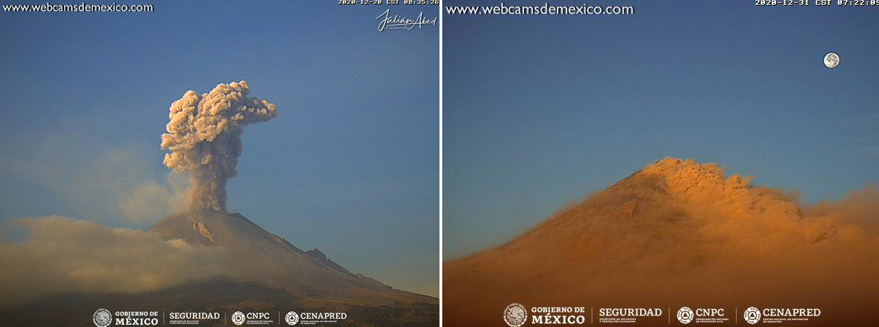
Emissions of steam and gas with occasional low quantities of ash continued during December 2020. Six explosions on 5 December produced small ash plumes that rose 500-1,000 m above the crater. The next day two explosions produced plumes that rose less than 1,500 m above the crater and drifted NE. Incandescent ejecta was captured in the webcam on 14 December (figure 171). The Washington VAAC issued multiple aviation alerts nearly every day of the month; ash plumes generally rose to 6-7 km altitude and drifted 30-50 km before dissipating. Activity increased during the second half of the month (figure 172). Visible ejecta was seen in webcams during low-energy emissions on 24 December, accompanied by an ash plume that rose 1,000 m above the crater. The next day an ash emission rose 300 m. Ejecta was noted on the SE flank after an explosion on 27 December, and ash plumes rose to 500-1,400 m above the crater each day through the end of December and into January 2021. Thermal anomalies appeared in satellite data inside the summit crater on 2, 17, 22, and 27 December.
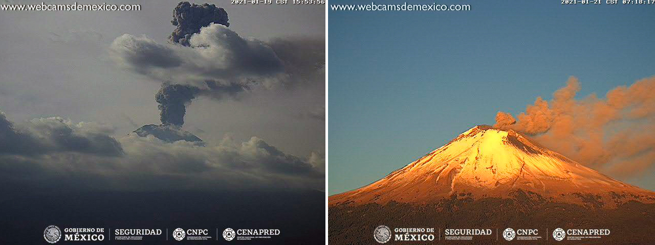
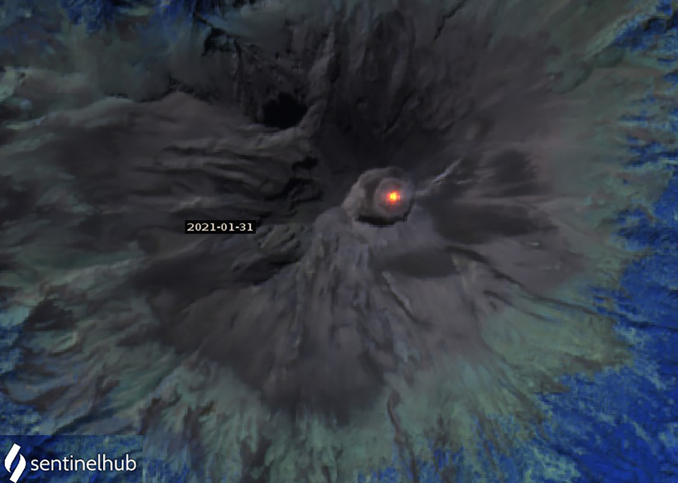
Daily ash emissions were reported by the Washington VAAC during January 2021, rising to 5.8-7.0 km altitude and drifting tens or hundreds of kilometers before dissipating (figure 173). Ash plumes rose 500-600 m above the crater on 1 and 2 January; at least one explosion each of those days produced incandescent ejecta in and around the crater. The Washington VAAC reported the ash plume from 1 January as visible in the webcam and satellite imagery over 200 km NE from the summit before dissipating, and one on 6 January visible about 100 km E of the volcano (figure 174). Ashfall was reported each day during 4-6 January in Puebla to the NW. On 8 January ashfall occurred in Atlixco (23 km SE), San Andrés Cholula (35 km E), San Nicolás de los Ranchos (15 km ENE) and Domingo Arenas (22 km NE), all in the state of Puebla. The following day ashfall was reported in San Salvador el Verde (30 km NNE) and San Nicolás de los Ranchos. Multiple explosions with ash plumes rising 500-700 m were reported on 14 and 15 January followed the next day by ashfall in San Nicolás de los Ranchos. Trace amounts of ash were reported in Tetela del Volcán (18 km SW) in the State of Morelos on 22 January. An explosion on 26 January ejected ash 700 m high and sent incandescent fragments a short distance from the crater rim. Ashfall on 28 January was reported in Ixtlacuixtla de Mariano, Nativitas and part of the center of Tlaxcala (50 km NE). The circular inner crater rim at the summit was sharply defined in a satellite image taken on 31 January 2021; a thermal anomaly was also present inside the crater (figure 175).
Geological Summary. Volcán Popocatépetl, whose name is the Aztec word for smoking mountain, rises 70 km SE of Mexico City to form North America's 2nd-highest volcano. The glacier-clad stratovolcano contains a steep-walled, 400 x 600 m wide crater. The generally symmetrical volcano is modified by the sharp-peaked Ventorrillo on the NW, a remnant of an earlier volcano. At least three previous major cones were destroyed by gravitational failure during the Pleistocene, producing massive debris-avalanche deposits covering broad areas to the south. The modern volcano was constructed south of the late-Pleistocene to Holocene El Fraile cone. Three major Plinian eruptions, the most recent of which took place about 800 CE, have occurred since the mid-Holocene, accompanied by pyroclastic flows and voluminous lahars that swept basins below the volcano. Frequent historical eruptions, first recorded in Aztec codices, have occurred since Pre-Columbian time.
Information Contacts: Centro Nacional de Prevención de Desastres (CENAPRED), Av. Delfín Madrigal No.665. Coyoacan, México D.F. 04360, México (URL: http://www.cenapred.unam.mx/, Daily Report Archive https://www.gob.mx/cenapred/archivo/articulos); MIROVA (Middle InfraRed Observation of Volcanic Activity), a collaborative project between the Universities of Turin and Florence (Italy) supported by the Centre for Volcanic Risk of the Italian Civil Protection Department (URL: http://www.mirovaweb.it/); Washington Volcanic Ash Advisory Center (VAAC), Satellite Analysis Branch (SAB), NOAA/NESDIS OSPO, NOAA Science Center Room 401, 5200 Auth Rd, Camp Springs, MD 20746, USA (URL: www.ospo.noaa.gov/Products/atmosphere/vaac, archive at: http://www.ssd.noaa.gov/VAAC/archive.html); Sentinel Hub Playground (URL: https://www.sentinel-hub.com/explore/sentinel-playground); NASA Global Sulfur Dioxide Monitoring Page, Atmospheric Chemistry and Dynamics Laboratory, NASA Goddard Space Flight Center (NASA/GSFC), 8800 Greenbelt Road, Goddard, Maryland, USA (URL: https://so2.gsfc.nasa.gov/).