Report on Telica (Nicaragua) — November 1977
Natural Science Event Bulletin, vol. 2, no. 11 (November 1977)
Managing Editor: David Squires.
Telica (Nicaragua) Explosions observed in late November
Please cite this report as:
Global Volcanism Program, 1977. Report on Telica (Nicaragua) (Squires, D., ed.). Natural Science Event Bulletin, 2:11. Smithsonian Institution. https://doi.org/10.5479/si.GVP.NSEB197711-344040
Telica
Nicaragua
12.606°N, 86.84°W; summit elev. 1036 m
All times are local (unless otherwise noted)
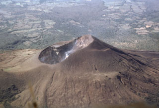
"During the early morning of 25 November, our group observed a series of ultravulcanian ash eruptions from Telica. An explosion was observed at 0605 from León, 19 km from Telica, producing a light brown ash cloud that rose 0.91 km above the summit. A dispersed cloud of ash from an earlier explosion was noted SW of the volcano. Four more explosions were observed, at 0617, 0622, 0626, and 0644. For the rest of the day, only intermittent observations were possible, but explosions were noted at 0740, 0835, and 1530. Ash fell in a zone extending about 5 km SSW of the volcano. Four kilometers from the source, the ash formed a discontinuous coating << 1 mm thick. Samples were collected for analysis at Dartmouth. A similar explosion, sending ash 1.6 km above the cone, was seen at 0605 on 26 November. At 0920 on 27 November, a dust cloud, presumably produced by another explosion, was seen from the air. The group reports that other Nicaraguan volcanoes show their normal level of fumarolic activity."
Geological Summary. Telica, one of Nicaragua's most active volcanoes, has erupted frequently since the beginning of the Spanish era. This volcano group consists of several interlocking cones and vents with a general NW alignment. Sixteenth-century eruptions were reported at symmetrical Santa Clara volcano at the SW end of the group. However, its eroded and breached crater has been covered by forests throughout historical time, and these eruptions may have originated from Telica, whose upper slopes in contrast are unvegetated. The steep-sided cone of Telica is truncated by a 700-m-wide double crater; the southern crater, the source of recent eruptions, is 120 m deep. El Liston, immediately E, has several nested craters. The fumaroles and boiling mudpots of Hervideros de San Jacinto, SE of Telica, form a prominent geothermal area frequented by tourists, and geothermal exploration has occurred nearby.
Information Contacts: R. Stoiber, R. Birnie, and S. Self, Dartmouth College.