Report on Shishaldin (United States) — February 1978
Scientific Event Alert Network Bulletin, vol. 3, no. 2 (February 1978)
Managing Editor: David Squires.
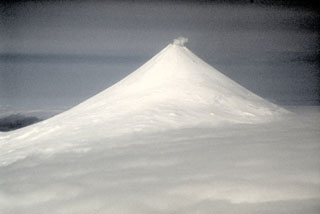
Shishaldin (United States) Large steam plume, accompanying nearby Westdahl eruption
Please cite this report as:
Global Volcanism Program, 1978. Report on Shishaldin (United States) (Squires, D., ed.). Scientific Event Alert Network Bulletin, 3:2. Smithsonian Institution. https://doi.org/10.5479/si.GVP.SEAN197802-311360
Shishaldin
United States
54.756°N, 163.97°W; summit elev. 2857 m
All times are local (unless otherwise noted)
A NOAA satellite image (figure 1) on 8 February at 1835 shows simultaneous 60-km plumes emerging from the summits of Shishaldin and Westdahl, about 50 km apart. No plume from Shishaldin is visible in images taken 8 hours earlier and 16 hours later (figure 2). No ashfall at Shishaldin can be seen in the latter image, but resolution is only 0.9 km and a light or moderate ashfall would probably not be visible.
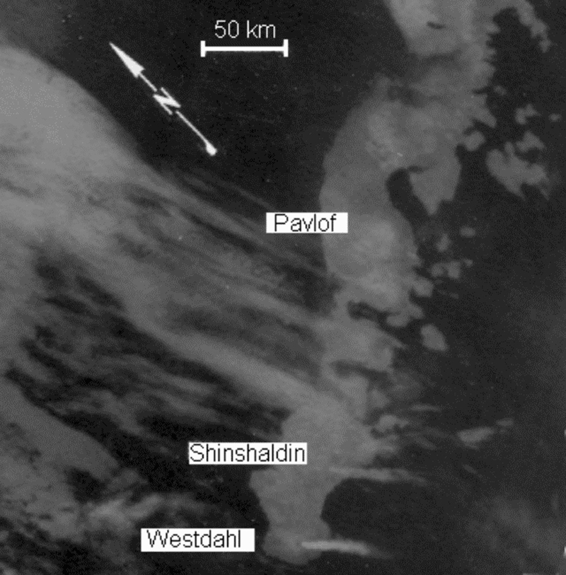 |
Figure 1. Enlargement of a portion of a NOAA 5 infrared image at 1835 on 8 February 1978 (0.9-km ground resolution), showing plumes, each ~60 km long, extending SE from both Westdahl and Shishaldin. Most of the Alaska Peninsula is visible, as is the coast of Alaska NW to the entrance to Kuskokwim Bay. The gray area off the coast is pack ice. Courtesy of Jürgen Kienle and NOAA. |
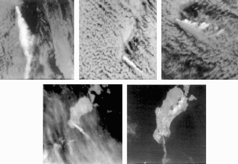 |
Figure 2. NOAA 5 satellite imagery, 5-9 February 1978, showing Unimak Island and vicinity. North orientations (arrow) are the same for each. A: (5 February 1978, 1036, infrared) Plume extends ~230 km S, rising to an estimated 8 km; black summit hot spot. B: (6 February 1978, 1141, infrared) Plume extends ~110 km SE; black summit hot spot. C: (7 February 1978, 1101, infrared) Plume at least 6 km high and ~160 km long, blown primarily SSE but some eastward shearing evident, probably by lower altitude winds. D: (8 February 1978, 1018, infrared) Plume extends 80 km SSE, at lower altitude than in C. E: (8 February 1978, 1018, visible, enlarged ~50% more than A-D) Weak plume curves SW to W about 100 km. Shishaldin is no longer active, 16 hours after its plume was visible in figure 1. The dark triangular area S of Westdahl is fresh ashfall, subtending an angle of about 95° and covering an area of ~300 km2. No ashfall is visible on Shishaldin. Courtesy of Jürgen Kienle and NOAA. |
Geological Summary. The symmetrical glacier-covered Shishaldin in the Aleutian Islands is the westernmost of three large stratovolcanoes in the eastern half of Unimak Island. The Aleuts named the volcano Sisquk, meaning "mountain which points the way when I am lost." Constructed atop an older glacially dissected edifice, it is largely basaltic in composition. Remnants of an older edifice are exposed on the W and NE sides at 1,500-1,800 m elevation. There are over two dozen pyroclastic cones on its NW flank, which is covered by massive aa lava flows. Frequent explosive activity, primarily consisting of Strombolian ash eruptions from the small summit crater, but sometimes producing lava flows, has been recorded since the 18th century. A steam plume often rises from the summit crater.
Information Contacts: J. Kienle, Univ. of Alaska.