Report on Kilauea (United States) — April 1982
Scientific Event Alert Network Bulletin, vol. 7, no. 4 (April 1982)
Managing Editor: Lindsay McClelland.
Kilauea (United States) Small fissure eruption in summit caldera
Please cite this report as:
Global Volcanism Program, 1982. Report on Kilauea (United States) (McClelland, L., ed.). Scientific Event Alert Network Bulletin, 7:4. Smithsonian Institution. https://doi.org/10.5479/si.GVP.SEAN198204-332010
Kilauea
United States
19.421°N, 155.287°W; summit elev. 1222 m
All times are local (unless otherwise noted)
"A summit eruption began at 1137 on 30 April and lasted about 19 hours, preceded by a microearthquake swarm about 3 hours long. Earthquakes at 1-3 km depth and magnitudes of less than 3 occurred in the S part of the caldera (figure 8). Rapid inflation of 5.5 µrad was recorded at the Uwekahuna tiltmeter, on the NW rim of the caldera, during the earthquake swarm (figure 9).
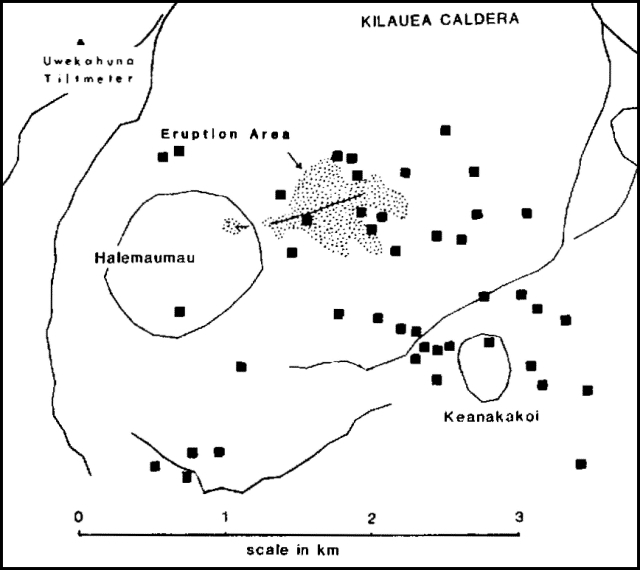 |
Figure 8. Sketch map of Kīlauea Caldera, showing locations of the 30 April-1 May eruption fissures (hachured lines), the area covered by the new lava flows (stippled), and the earthquakes that preceded the eruption (solid squares). |
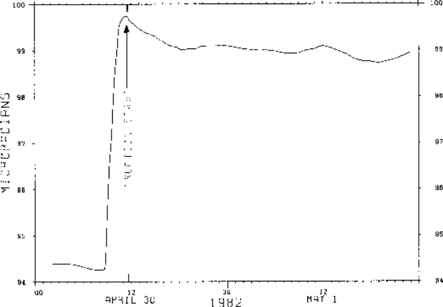 |
Figure 9. Tilt measured 30 April - 1 May at Uwekahuna, on the NW rim of the caldera. Increasing tilt readings correspond to summit inflation (up to E). The eruption began at 1137, just after maximum tilt. |
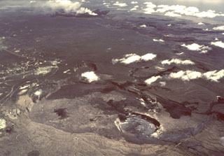
"Lava was erupted from an ENE-trending fissure approximately 1 km long. The fissure, on the S flank of the 1954 spatter ramparts, first opened near its E end about 2 minutes before spatter appeared. Steam emission closely followed opening of the crack as it extended in length both to the E and W. Preliminary data indicate that the line of vents propagated both E and W from the initial vent. Eastward propagation occurred at about 1-2 m/second. The entire line of vents, including its westernmost part (in Halemaumau pit crater), was active within 25 minutes of the eruption's start, forming a nearly continuous and steady curtain of spatter on the order of 5-10 m high with bursts to 25-50 m. Lava flows to the N, E, and S, which eventually formed prominent lobes, were under way within minutes of the beginning of the eruption.
"A decrease in eruption rates near the ends of the line of vents was first recognized at approximately 1630, about 5 hours from the beginning of the eruption. About an hour later (at 1740) the westernmost vents, except for those in Halemaumau, had shut off, and drainback was occurring in the area of the central vents, from which the relatively extensive flows to the N and S were fed. By 2100, only the central 150-200 m of the fissure system was active. At this group of vents, activity continued steadily until about midnight, after which the rate of fountaining decreased and the length of the active fissure system gradually diminished.
"A preliminary estimate suggests that the volume of new lava is about 0.5 x 10⁶ m3, primarily pahoehoe flows. A quick hand-lens inspection suggests that it is aphyric, or has at most rare olivine microphenocrysts. Relatively high temperatures, about 1,135-1,150°C, were measured by thermocouple and two-wavelength infrared pyrometer. Minimal fume production, relatively high density of spatter, and low fountain heights suggest that the gas content of the lava was low. However, gas bursting increased in the last hours of the eruption as the rate of fountain activity waned at the remaining centrally located vents. Frothy pumiceous lapilli were ejected during this phase."
Geological Summary. Kilauea overlaps the E flank of the massive Mauna Loa shield volcano in the island of Hawaii. Eruptions are prominent in Polynesian legends; written documentation since 1820 records frequent summit and flank lava flow eruptions interspersed with periods of long-term lava lake activity at Halemaumau crater in the summit caldera until 1924. The 3 x 5 km caldera was formed in several stages about 1,500 years ago and during the 18th century; eruptions have also originated from the lengthy East and Southwest rift zones, which extend to the ocean in both directions. About 90% of the surface of the basaltic shield volcano is formed of lava flows less than about 1,100 years old; 70% of the surface is younger than 600 years. The long-term eruption from the East rift zone between 1983 and 2018 produced lava flows covering more than 100 km2, destroyed hundreds of houses, and added new coastline.
Information Contacts: Hawaiian Volcano Observatory, USGS.