Report on Lonquimay (Chile) — September 1989
Scientific Event Alert Network Bulletin, vol. 14, no. 9 (September 1989)
Managing Editor: Lindsay McClelland.
Lonquimay (Chile) Continued tephra emission and lava flow; fluorine data
Please cite this report as:
Global Volcanism Program, 1989. Report on Lonquimay (Chile) (McClelland, L., ed.). Scientific Event Alert Network Bulletin, 14:9. Smithsonian Institution. https://doi.org/10.5479/si.GVP.SEAN198909-357100
Lonquimay
Chile
38.379°S, 71.586°W; summit elev. 2832 m
All times are local (unless otherwise noted)
A public statement issued by geologists on 4 August noted that the plume then being emitted was unlikely to have any direct noxious effects on people or animals. However, they recommended that livestock not be fed forage cut during the more vigorous activity of January-March. Continued sampling of ash, water, and pasture vegetation were also recommended, particularly stream and well water during melting of the snow cover with its load of ash and fluorine.
Inward slumping of part of the wall of Navidad Crater occurred on 10 August [but see 14:11]. There was no immediate change in the relatively low rate of ash emission, but an increase occurred several days later, with winds blowing the plume SE toward Lonquimay village. Ash emission again increased substantially on 10 September, feeding an ash-rich column >3,000 m high. Because of the stronger activity, authorities halted the return of >1,000 students that had begun in July; only 100 had come back to the area.
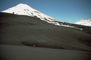
During a 17 September overflight, Sergio Barrientos and Hugo Moreno (Univ de Chile) and Pedro Riffo, Gustavo Fuentealba, and Mario Villouta (Univ de la Frontera) observed a 1,000-1,200-m-high eruption column feeding a thin but continuous plume that extended >200 km N. Two small vents were active on Navidad Crater. The upper vent emitted a steam jet, volcanic gases, and fine ash, while lava poured from the lower vent, accompanied by spattering up to 50 m high. The lava flow in the Lolco River valley was still advancing; its front was ~10.5 km from the vent and its maximum width was 1.2 km. Damming of streams by the lava flow had formed five small new lakes, the largest in the Holandesa valley, a tributary that enters the Río Lolco ~9.5 km from Navidad Crater. About 200 x 106 m3 of lava have been erupted since activity began and the effusion rate has been around 300,000 m3/day during the last 5 months.
On 19 September at 0025, a M 4.3 earthquake affected the Malalcahuello area, 12 km S of Navidad Crater, (at MM VI-VII) and numerous smaller events (up to MM IV) were felt in the following days. The seismicity broke 92 windows at the Malalcahuello school and caused other structural damage there and in Manzanar, ~10 km to the W. After the main shock, the eruptive activity increased and the ash column rose to 3,500 m height, but the increased eruptive activity lasted for only 3 days, ending shortly after a felt shock at 2115 on 22 September. Three seismographs were installed on 23 September (at Guamachuco, roughly 7 km SW of Navidad Crater; Malalcahuello; and the Cautín River, a few km SE of Navidad) on the first of 4 days of field work by the geologists from the Univ de Chile and the Univ de la Frontera. Between 23 and 26 September, only three small earthquakes were registered. S. Barrientos interpreted the seismic activity as a "roof collapse" in the magma chamber.
Ash thicknesses at six sites previously sampled on 3 February had increased 3- to 4-fold when measured again on 25 September (table 9). Most ash continued to fall roughly to the SE in the Lonquimay valley, but winds occasionally changed, sending the plume to the S, W, or N for a few hours. Fluorine concentration in grass had also increased from 16 July values at the same sites (table 10). Geologists noted that although the plume was weaker in September than in December-March, it was also at a lower altitude that may locally increase fluorine deposition. The snow cap that covered the grass during May-July could have first isolated the grass from fluorine deposition, then concentrated flourine as the snow melted. Previous fluorine analyses by Villa show considerable variations between fluorine contents of different types of vegetation in the same area (table 11). Carlos Ducom (a Lonquimay veterinarian) reported that 4,158 animals have died because of ash and fluorine: 2,040 goats, 1,479 sheep, 371 cattle, and 268 horses.
Table 9. Comparisons of ash thicknesses (in millimeters) at six sites on 3 February and 25 September 1989. Courtesy of H. Moreno.
| Location | 3 Feb 1989 | 25 Sep 1989 |
| Cautin River | 20 mm | 58 mm |
| Cautin River (bridge) | 8 mm | 33 mm |
| Lonquimay ski hut | 15 mm | 43 mm |
| Los Condores | 10 mm | 30 mm |
| La Plancha (6 km SE) | 4 mm | 25 mm |
| La Paloma (14 km SSE) | 3.5 mm | 12 mm |
Table 10. Fluorine concentrations (in ppm) found in grass at several locations, January-September 1989, analyzed by Alberto Villa, INTA, Univ de Chile. Courtesy of H. Moreno.
| Location | Jan/Mar | Jul | Sep |
| Rucamanque (25 km ESE) | 105 | 31 | 107 |
| Bernardo Nanco | 205 | 30 | 290 |
| Laguna Jara (25 km ESE) | -- | 63 | 143 |
| Lonquimay (20 km ESE) | -- | 47 | 179 |
| Sierra Nevada | -- | 23 | 65 |
Table 11. Fluorine concentrations of vegetation (weight/dry weight) from duplicate analyses by Alberto Villa, with coefficients of variation of 3-5%. The Pichipehuenco samples are from different farms. Ranquil is 25 km NE, Mitranquen Bajo is 35 km ESE, Caracoles is 25 km E, and Pichipehuenco is 40 km SE. Courtesy of O. González-Ferrán.
| Location | Month | Vegetation | Fluorine (ppm) |
| Ranquil | Feb 1989 | Hay | 65 |
| Ranquil | May 1989 | Grass | 52 |
| Mitranquen Bajo | Feb 1989 | Hay | 416 |
| Mitranquen Bajo | May 1989 | Grass | 228 |
| Caracoles | Feb 1989 | Hay | 340 |
| Caracoles | Feb 1989 | Meadow | 162 |
| Caracoles | Feb 1989 | Bamboo | 141 |
| Caracoles | Feb 1989 | Broom sedge | 37 |
| Pichipehuenco | Feb 1989 | Apples | 2 |
| Pichipehuenco | May 1989 | Grass | 121 |
Geological Summary. Lonquimay is a small, flat-topped, symmetrical stratovolcano of late-Pleistocene to dominantly Holocene age immediately SE of Tolguaca volcano. A glacier fills its summit crater and flows down the S flank. It is dominantly andesitic, but basalt and dacite are also found. The prominent NE-SW Cordón Fissural Oriental fissure zone cuts across the entire volcano. A series of NE-flank vents and scoria cones were built along an E-W fissure, some of which have been the source of voluminous lava flows, including those during 1887-90 and 1988-90, that extended out to 10 km.
Information Contacts: H. Moreno and S. Barrientos, Univ de Chile; P. Riffo, Univ de la Frontera; O. González-Ferrán, Univ de Chile.