Report on Reykjanes (Iceland) — 20 March-26 March 2024
Smithsonian Institution / US Geological Survey
Weekly Volcanic Activity Report, 20 March-26 March 2024
Managing Editor: Sally Sennert.
Written by Zachary W. Hastings.
Please cite this report as:
Global Volcanism Program, 2024. Report on Reykjanes (Iceland) (Hastings, Z W, and Sennert, S, eds.). Weekly Volcanic Activity Report, 20 March-26 March 2024. Smithsonian Institution and US Geological Survey.
Reykjanes
Iceland
63.817°N, 22.717°W; summit elev. 140 m
All times are local (unless otherwise noted)
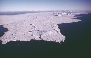
According to the Icelandic Meteorological Office (IMO), eruptive activity along the fissure that opened on 16 March began to stabilize on 20 March, with vents remaining in the same locations as previous days where cones had been built. The lava flows traveled S on top of older flows from the previous episodes in December 2023 and January-February 2024. Little or no change was observed at the flow fronts near Suðurstrandarvegur (the southern coast road) and Svartsengi. Lava began to flow into Melhólsnáma mine during 23-24 March, eventually filling it. Seismicity remained low. Early SO2 flux measurements from 17 March were up to 50 kg/s, but preliminary results from a more recent measurement indicated that the rate had decreased substantially. On the morning of 20 March, the National Land Survey of Iceland and the Institute of Natural History conducted aerial photography flights. Based on image analysis, an average discharge rate of 14.5 cubic meters per second during 17-20 March was estimated, and the new lava field was about 5.58 square kilometers with a volume of 20.9 million cubic meters. By 25 March the eruptive activity had decreased and possibly ceased at the smaller cones. The cones that remained active continued to grow, and the main lava flow extended south and bent westward. Seismicity and volcanic tremor gradually decreased. GPS monitoring continued to detect inflation at Svartsengi, but at a slower rate. High levels of SO2 were measured in Höfn and Grindavík over the past few days, and IMO warned of risk associated with gas emissions.
Geological Summary. The Reykjanes volcanic system at the SW tip of the Reykjanes Peninsula, where the Mid-Atlantic Ridge rises above sea level, comprises a broad area of postglacial basaltic crater rows and small shield volcanoes. The submarine Reykjaneshryggur volcanic system is contiguous with and is considered part of the Reykjanes volcanic system, which is the westernmost of a series of four closely-spaced en-echelon fissure systems that extend diagonally across the Reykjanes Peninsula. Most of the subaerial part of the system (also known as the Reykjanes/Svartsengi volcanic system) is covered by Holocene lavas. Subaerial eruptions have occurred in historical time during the 13th century at several locations on the NE-SW-trending fissure system, and numerous submarine eruptions dating back to the 12th century have been observed during historical time, some of which have formed ephemeral islands. Basaltic rocks of probable Holocene age have been recovered during dredging operations, and tephra deposits from earlier Holocene eruptions are preserved on the nearby Reykjanes Peninsula.
Sources: Icelandic Meteorological Office (IMO), Almannavarnadeild ríkislögreglustjóra (National Commissioner of the Icelandic Police and Department of Civil Protection and Emergency Management)