The Global Volcanism Program has no activity reports for Jolo.
The Global Volcanism Program has no Weekly Reports available for Jolo.
The Global Volcanism Program has no Bulletin Reports available for Jolo.
This compilation of synonyms and subsidiary features may not be comprehensive. Features are organized into four major categories: Cones, Craters, Domes, and Thermal Features. Synonyms of features appear indented below the primary name. In some cases additional feature type, elevation, or location details are provided.
Synonyms |
||||
| Sulu | Solo | Tipt Pon | ||||
Cones |
||||
| Feature Name | Feature Type | Elevation | Latitude | Longitude |
|
Bud Dajo
Buddajo |
Pyroclastic cone | 620 m | 6° 0' 48" N | 121° 3' 24" E |
| Dakula, Mount | Pyroclastic cone | 399 m | 5° 59' 0" N | 121° 11' 0" E |
| Dakut | Cone | 474 m | 5° 44' 0" N | 120° 56' 0" E |
| Gorra | Cone | 496 m | 5° 33' 0" N | 120° 49' 0" E |
| Guimba | Pyroclastic cone | 482 m | ||
| Lapac | Cone | 357 m | 5° 31' 0" N | 120° 46' 0" E |
| Matanding | Pyroclastic cone | 400 m | ||
| Parang | Cone | 422 m | 5° 49' 0" N | 121° 10' 0" E |
| Parangan | Cone | 389 m | 5° 58' 30" N | 121° 24' 0" E |
| Pitogo | Cone | 392 m | 5° 54' 18" N | 121° 18' 0" E |
| Sinumaan | Cone | 785 m | 6° 2' 0" N | 121° 6' 0" E |
| Sungal | Pyroclastic cone | 518 m | ||
| Talipao, Mount | Pyroclastic cone | 440 m | 5° 57' 0" N | 121° 4' 0" E |
| Tukay | Cone | 609 m | 5° 56' 0" N | 120° 57' 0" E |
| Tumatangas | Pyroclastic cone | 811 m | 5° 59' 54" N | 120° 58' 0" E |
Craters |
||||
| Feature Name | Feature Type | Elevation | Latitude | Longitude |
| Panamao, Mount | Crater | 220 m | 5° 58' 0" N | 121° 10' 0" E |
|
|
||||||||||||||||||||||||
There is data available for 0 confirmed Holocene eruptive periods.
[ 1897 Sep 21 ] Discredited Eruption
A possible submarine eruption on 21 September 1897 was listed by CAVW and PHIVOLCS (2004-). However, a significant tsunami resulted from large tectonic earthquakes at 1906 on 20 September and at 0512 on the 21st; Abe (1994) recalculated their magnitudes as 7.4 and 7.5, respectively. It's not clear where the idea of an eruption came from, but Maso (1904) speculates that "there must have occurred some great submarine displacements or eruptions to cause such wide perturbation." The summary of reported events by Maso (1904) does not include anything that could be considered eruptive activity. General bathymetry does show what appear to be submarine landslides along the southern border of the island arc that includes Jolo.
[ 1641 Jan 4 ] Discredited Eruption
A possible explosive eruption was reported on Jolo Island on 4 January 1641 (Neumann van Padang, 1953). A major eruption in the southern Philippines/northern Indonesia region on this date was reported from several volcanoes, including Awu in Indonesia. More recent work has shown that this major eruption originated from Parker volcano in southern Mindanao (Delfin et al., 1997).
There is no Deformation History data available for Jolo.
There is no Emissions History data available for Jolo.
 The dumbbell-shaped, E-W-trending Jolo island contains numerous pyroclastic cones and craters, some of which are visible in this Space Shuttle image with north to the upper left. The island is about 60 km wide in an E-W direction; its largest city, Jolo, lies on the northern coast (left-center). The isolated location of Jolo at the SW end of the Philippines archipelago as well as political unrest have inhibited geological studies of the volcano.
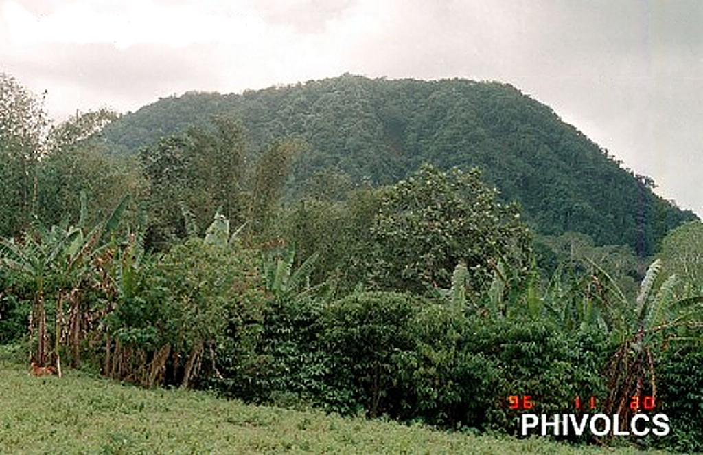
  Forested Bud Dajo cinder cone is one of numerous pyroclastic cones and craters that dot 60-km-wide Jolo Island at the SW end of the Philippines archipelago. Bud Dajo (or Buddajo) is a young basaltic cinder cone that reaches 620 m elevation; nearby cones are Matanding, Guimba, and Sungal. Hot springs have been reported at craters on Cagayan Sulu, and solfataras at Siit Lake. A tsunami accompanied a possible submarine eruption in 1897.
  The 61-km-long Jolo island contains numerous cones and craters, some of which are visible in this August 2019 Planet Labs satellite image monthly mosaic (N is at the top). The 1.3-km-diameter lake-filled crater visible in the center of the island is Mount Panamao.
The maps shown below have been scanned from the GVP map archives and include the volcano on this page. Clicking on the small images will load the full 300 dpi map. Very small-scale maps (such as world maps) are not included. The maps database originated over 30 years ago, but was only recently updated and connected to our main database. We welcome users to tell us if they see incorrect information or other problems with the maps; please use the Contact GVP link at the bottom of the page to send us email.
There are no samples for Jolo in the Smithsonian's NMNH Department of Mineral Sciences Rock and Ore collection.
| Copernicus Browser | The Copernicus Browser replaced the Sentinel Hub Playground browser in 2023, to provide access to Earth observation archives from the Copernicus Data Space Ecosystem, the main distribution platform for data from the EU Copernicus missions. |
|
WOVOdat
Single Volcano View Temporal Evolution of Unrest Side by Side Volcanoes |
WOVOdat is a database of volcanic unrest; instrumentally and visually recorded changes in seismicity, ground deformation, gas emission, and other parameters from their normal baselines. It is sponsored by the World Organization of Volcano Observatories (WOVO) and presently hosted at the Earth Observatory of Singapore.
GVMID Data on Volcano Monitoring Infrastructure The Global Volcano Monitoring Infrastructure Database GVMID, is aimed at documenting and improving capabilities of volcano monitoring from the ground and space. GVMID should provide a snapshot and baseline view of the techniques and instrumentation that are in place at various volcanoes, which can be use by volcano observatories as reference to setup new monitoring system or improving networks at a specific volcano. These data will allow identification of what monitoring gaps exist, which can be then targeted by remote sensing infrastructure and future instrument deployments. |
| IRIS seismic stations/networks | Incorporated Research Institutions for Seismology (IRIS) Data Services map showing the location of seismic stations from all available networks (permanent or temporary) within a radius of 0.18° (about 20 km at mid-latitudes) from the given location of Jolo. Users can customize a variety of filters and options in the left panel. Note that if there are no stations are known the map will default to show the entire world with a "No data matched request" error notice. |
| UNAVCO GPS/GNSS stations | Geodetic Data Services map from UNAVCO showing the location of GPS/GNSS stations from all available networks (permanent or temporary) within a radius of 20 km from the given location of Jolo. Users can customize the data search based on station or network names, location, and time window. Requires Adobe Flash Player. |
| Large Eruptions of Jolo | Information about large Quaternary eruptions (VEI >= 4) is cataloged in the Large Magnitude Explosive Volcanic Eruptions (LaMEVE) database of the Volcano Global Risk Identification and Analysis Project (VOGRIPA). |
| EarthChem | EarthChem develops and maintains databases, software, and services that support the preservation, discovery, access and analysis of geochemical data, and facilitate their integration with the broad array of other available earth science parameters. EarthChem is operated by a joint team of disciplinary scientists, data scientists, data managers and information technology developers who are part of the NSF-funded data facility Integrated Earth Data Applications (IEDA). IEDA is a collaborative effort of EarthChem and the Marine Geoscience Data System (MGDS). |

