Theme Collections | Tom Casadevall Photos
Theme collections are galleries not specifically related to volcanic hazards, processes, research, types, or features. This includes subjects such as different satellite platforms, astronaut photos from the Space Shuttle, specific photographers, or other special collections.
Image Gallery for Tom Casadevall Photos
Photos by Tom Casadevall (U.S. Geological Survey). There are 75 images available.
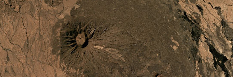
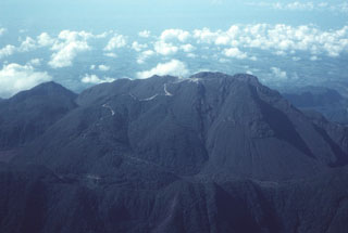
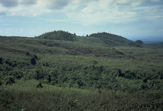
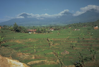
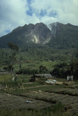
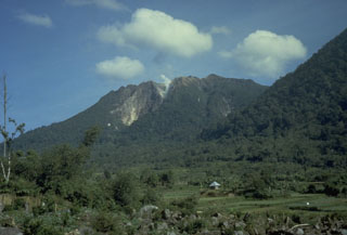
 The topographic high point of the fault-bounded central horst of La Yeguada volcanic complex is Cerro el Castillo (right center). It and Cerro Novillo at the lower right are part of older Miocene rocks uplifted in the horst. Quaternary volcanism took place in the northern part of the horst, out of view to the right, about 220,000 years ago. In the background are extensive Tertiary ignimbrite deposits of La Yeguada formation, some of which are thought to have originated from vents in the central horst.
Photo by Tom Casadevall, 1994 (U.S. Geological Survey).
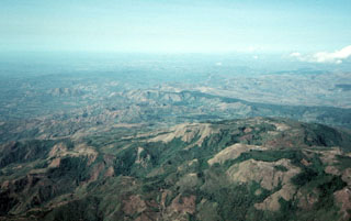
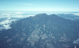
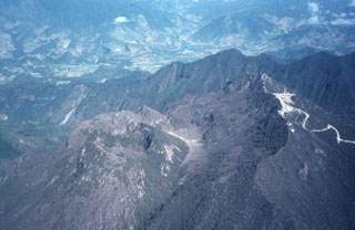
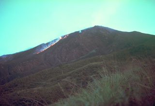
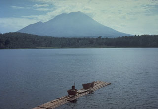
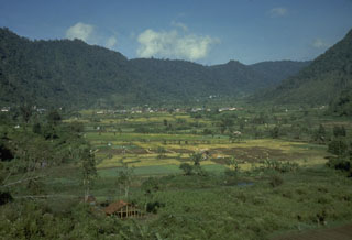
 La Yeguada volcanic complex is in the foreground with Laguna La Yeguada (center) to the west. This massive volcanic center, also known as Chitra-Calobre, lies in west-central Panamá. El Castillo dome (left) is the high point of the complex, and Cerro Corero de la Charca (right) is a late-Pleistocene lava dome.
 Photo by Tom Casadevall, 1994 (U.S. Geological Survey).
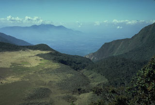
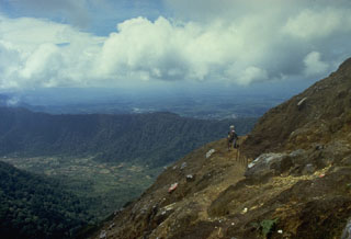
 The Volcán Barú summit lava dome complex is seen in this view from the NE. The complex formed within a large 6 x 10 km horseshoe-shaped collapse scar, with its eastern scarp forming the ridge extending across the bottom of the photo. The peak to the far left is part of the southeastern scarp.
Photo by Tom Casadevall, 1994 (U.S. Geological Survey).
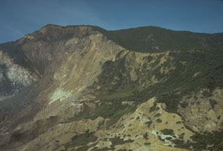
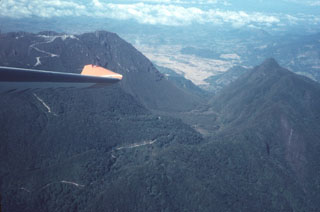 The outer eastern flanks of the large Volcán Barú collapse scar are in the foreground, with the northern scarp forming the ridge to the right. The road to the left crosses over the scarp into its moat and then up to the top of a post-collapse lava dome complex that forms the summit.
Photo by Tom Casadevall, 1994 (U.S. Geological Survey).
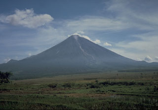
 This photo shows Volcán Barú from the ESE. The summit lava dome complex appears beyond the back wall of a large collapse scarp that forms an irregular ridge near the summit. The flat-topped edifice beyond Barú to the right (NW) is the Pleistocene Volcán Colorado.
 Photo by Tom Casadevall, 1994 (U.S. Geological Survey).
 The summit of Barú volcano is just above the wing tip in this view from the SE. Communication towers line the ridge to the right of the summit. Behind it is the northern wall of a large horseshoe-shaped collapse scarp. The Pleistocene Volcán Colorado is under clouds to the upper right.
Photo by Tom Casadevall, 1994 (U.S. Geological Survey).
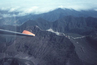
 The Volcán Barú summit lava dome complex is seen here from the SE. The road to the right leads to communication towers at the summit. The ridge extending across the photo beyond the domes is the northern headwall of a large horseshoe-shaped collapse scarp.
 Photo by Tom Casadevall, 1994 (U.S. Geological Survey).
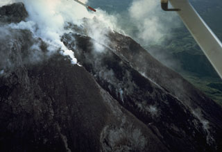
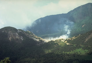
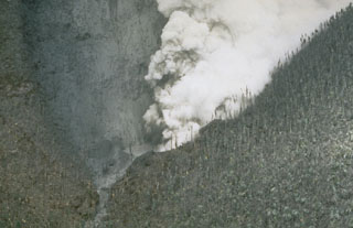 Steam pours from a vent blasted through the SW side of Castle Peak dome on July 28, 1995. This view from the east on August 5 shows trees that were defoliated by ashfall.
Photo by Tom Casadevall, 1995 (U.S. Geological Survey).
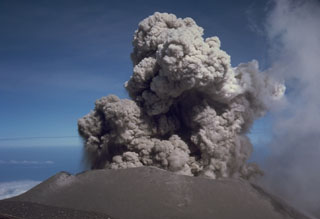
 The first explosion of the eruption of Soufrière Hills that began in 1995 blasted a new crater on the NW side of Castle Peak lava dome in the center of English's Crater. Steam rises from the new crater in this August 4, 1995, view from the NW, and a coating of gray ash blankets vegetation around the vent. A second crater was formed on July 28 on the SW side of the dome. It was one of several that were created during phreatic eruptions that preceded growth of a new lava dome beginning in November 1995.
Photo by Tom Casadevall, 1995 (U.S. Geological Survey).
 The Unzen volcanic complex comprises much of the Shimabara Peninsula east of Nagasaki, seen here looking to the W from across Shimabara Bay. Three large edifices are visible: Kinugasa to the N, Fugendake in the E-center, and Kusenbu on the S. Historical eruptive activity has occurred at the summit and flanks of Fugendake. Activity during 1990-95 formed a lava dome at the summit that produced pyroclastic flows (block-and-ash flows).
Photo by Tom Casadevall, 1991 (U.S. Geological Survey).
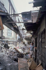 Heavy ashfall from the 15 June 1991 eruption of Pinatubo caused collapse of the roof of this public market in Olapango City near Subic Bay Naval Air Station. About 10-15 cm of ash fell at this location, 35 km S of the volcano.
Photo by Tom Casadevall, 1991 (U.S. Geological Survey).
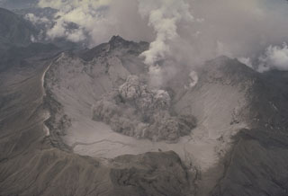 The beginning of a small explosion within the new summit caldera of Pinatubo is seen from the NE on 1 August 1991. After the 2.5-km-wide caldera formed during the 15 June climactic eruption, frequent ash emission lasted through much of July. The caldera floor became visible for the first time when activity changed to intermittent explosions. By September 1991 a lake began to form from the accumulation of rainwater and groundwater from within the volcano; it eventually expanded to cover the caldera floor.
Photo by Tom Casadevall, 1991 (U.S. Geological Survey).
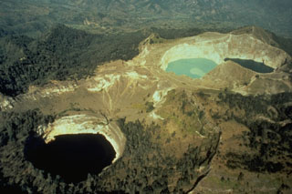
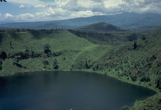
 The SE-most pair of Kelimutu's crater lakes, Tiwu Ata Polo and Tiwu Nua Muri Kooh Tai, are seen here in an aerial view from the SE. A light-colored area of upwelling can be seen in the upper lake and this also occurs in the lower one. All three lakes are close to saturation with gypsum/anhydrite, contributing to color variations.
Photo by Tom Casadevall, (U.S. Geological Survey).
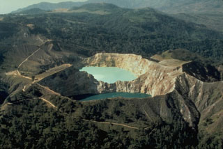
 Kelimutu, a small volcano on Flores Island, is noted for its three crater lakes of different colors. This aerial view from the SW shows Tiwu Ata Mbupu at the lower left, and the two craters of Tiwu Nua Muri Kooh Taiand Tiwu and Ata Polo at the upper right. Water color varies periodically with variations of blue, green, and red. Phreatic eruptions have occurred from the middle lake in historical time.
Photo by Tom Casadevall (U.S. Geological Survey).
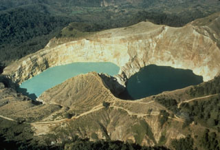 The two crater lakes of Kelimutu volcano on Indonesia's Flores Island are seen in this aerial view from the SW. Tiwu Nua Muri Kooh Tai (Lake of Young Men and Maidens) on the left and Tiwu Ata Polo (Bewitched or Enchanted Lake) are separated by a narrow crater wall about 35 m high. Phreatic eruptions have occurred from Tiwu Nua Muri Kooh Tai in the 19th and 20th centuries.
Photo by Tom Casadevall, 1986 (U.S. Geological Survey).
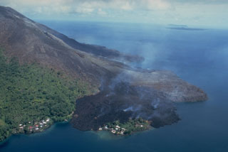 This May 19, 1988, view from the NE shows a still-steaming black lava flow entering the sea along the north coast, partially overrunning the village of Batu Angus. The lava flow originated from a vent at 200 m on the north flank on May 9, and reached the sea the same day. A second steaming lava flow, the Pasir Besar flow, which originated from a vent at 300-350 m elevation, can be seen reaching the NW coast at the center of the photo. The portion of Batu Angus village surrounded by the lava flow sits on an earlier lava flow erupted in 1901.
Photo by Tom Casadevall, 1988 (U.S. Geological Survey).
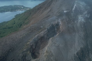 Fissures of vents no. 1 (bottom) and 3 (upper right) cut the northern flank of Banda Api volcano. Ash mantles vegetation adjacent to the fissures, which are about 15-20 m wide at this location. These vents, which began erupting on May 9, 1988, also fed two large lava flows that reached the sea along the northern and NW coasts. Neira Island appears in the background in this May 21, 1988 photo.
Photo by Tom Casadevall, 1988 (U.S. Geological Survey).
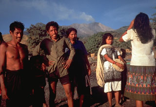
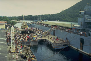 Evacuees on the island of Neira board an Indonesian Navy ship on 20 May 1988, bound for the island of Sulawesi. About 10,000 people of a population of 16,000 living in the Banda Islands were evacuated during the 1988 eruption. During the two days prior to the start of the eruption on the morning of 9 May, about 1800 people on Gunung Api Island (the site of the eruption) evacuated to Neira and Lonthor Islands. On the 9th, people began moving from Neira Island to Lonthur and then to more distant locations. The evacuation remained in effect until 13 June.
Photo by Tom Casadevall, 1988 (U.S. Geological Survey).
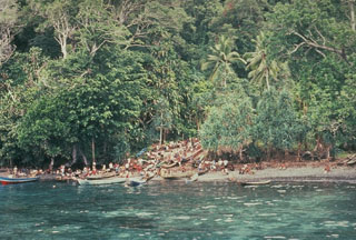 At the onset of the eruption of Banda Api on 9 May 1988, residents of Neira moved to the west side of the island to begin evacuations. Residents of nearby Gunung Api Island, where the eruption occurred, had been evacuated over the previous two days. As many as 10,000 people were evacuated during the eruption; the only people to lose their lives were four who remained in the evacuation zone.
Photo by Tom Casadevall, 1988 (U.S. Geological Survey).
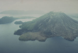
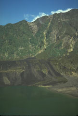
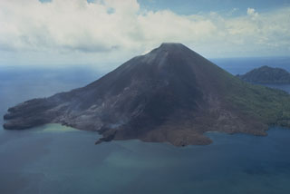 The 640-m-high symmetrical volcano of Banda Api, the most active of a chain of volcanoes in Indonesia's Banda Sea, forms a small 3-km-wide island within a largely submerged 7-km-wide caldera. This May 19, 1988, view from the south shows vegetation damage from the 1988 eruption and the southern half of a prominent arcuate fissure that extended from the south coast through the summit to 200 m above the north coast. The still-steaming narrow black lava flow entering the sea to the left of center is one of four erupted in 1988.
Photo by Tom Casadevall, 1988 (U.S. Geological Survey).
 Vegetation in the foreground and on the western tip of Lonthur Island in the background was destroyed and scorched by a directed blast produced by temporary deflection of the vertical plinian eruption column on May 9, 1988. Witnesses reported that at 11:30 am "the entire eruption column bent sidways towards the south," probably as a result of slumping of the uphill slope onto the vent. About 2 cm of tephra was deposited on Lonthur Island, but the village of Lonthur (left) was spared.
Photo by Tom Casadevall, 1988 (U.S. Geological Survey).
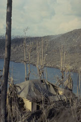 The roof of this house at Pasir Besar on the NW coast of Gunung Api Island collapsed as a result of the loading of ash and the impact of ballistic bombs from the May 9, 1988 eruption of Banda Api volcano. Tephra from the eruption was distributed primarily to the west. The barren slope in the background of this May 19 photo is the surface of the 1988 Pasir Besar lava flow, which descended to the sea from a vent on the northern flank.
 Photo by Tom Casadevall, 1988 (U.S. Geological Survey).
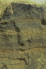 A 2.6-m-thick section at the airport on Neira Island (4.5 km from Banda Api volcano) shows 14 different tephra layers. The uppermost layer originated during an eruption in 1820, when the village was evacuated due to heavy ashfall. The section shows several layers of coarser, lighter-colored pumice and lapilli produced during more vigorous plinian eruptions than occurred in 1988.
Photo by Tom Casadevall, 1988 (U.S. Geological Survey).
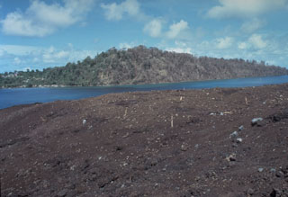
 The May 1988 north-flank lava flows reached the sea at two locations. The flows originated from a fissure that can be seen descending diagonally to the left from the summit. The Pasir Besar lava flow was erupted from a vent at about 300-350 m elevation and reached the sea along almost the full length of Pasir Besar bay at the right-center. The Batu Angus lava flow originated from a vent at 200 m elevation and reached the sea at the left-center after overrunning houses in the villages of Kalobi and Batu Angus.
Photo by Tom Casadevall, 1988 (U.S. Geological Survey).
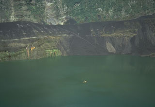
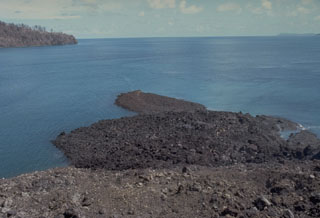 A small lava flow from a vent low on the south flank of Gunung Api flowed into the sea, forming a narrow peninsula. The May 9, 1988 lava flow was erupted from a 100-m-long fissure that produced a tuff cone over the vent. Minor submarine activity occurred at the lower end of the fissure. The western tip of Bantur Island appears in the background.
Photo by Tom Casadevall, 1988 (U.S. Geological Survey).
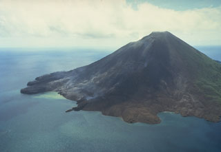 Gunung Api volcano is seen here in an aerial view from the south on May 19, 1988. The narrow peninsula at the left-center is the terminous of a still-steaming lava flow that was erupted from a vent low on the SW flank beginning on May 9. Another flow erupted from a vent at about 150 m elevation on the SW flank also reached the sea immediately to the west. The May 9 vents were located along an arcuate N-SSW-trending fissure that cut across the summit of the volcano.
Photo by Tom Casadevall, 1988 (U.S. Geological Survey).
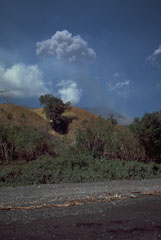
 Islanders prepare to evacuate on 25 August 1985 as Sangeang Api volcano erupts in the background. The eruption began on 30 July and produced pyroclastic flows that eventually forced the evacuation of the island's entire 1,242 inhabitants.
Photo by Tom Casadevall, 1985 (U.S. Geological Survey).
 A lava flow descends the W flank of Doro Api at Sangeang Api volcano on 4 December 1985. The eruption began on 30 July and pyroclastic flows forced the evacuation of the island's 1,242 inhabitants. The lava flow eventually traveled 4-5 km before stopping in June 1986. Explosive activity continued until February 1988.
Photo by Tom Casadevall, 1985 (U.S. Geological Survey).
 An ash plume rises above the Doro Api peak of Sangeang Api volcano on 25 August 1985. The eruption, which began on 30 July and lasted until February 1988, included explosive activity, pyroclastic flows, and a lava flow that traveled 4-5 km down the W flank.
Photo by Tom Casadevall, 1985 (U.S. Geological Survey).
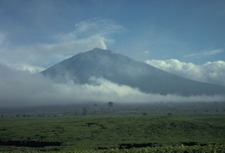
 Sangeang Api is a small volcanic island off the NE coast of Sumbawa Island. Two large cones, Doro Api in the center and Doro Mantai on the right, were constructed within and on the south rim of a largely obscured caldera. Intermittent eruptions have been recorded since 1512 and it has been frequently active in the 20th century.
Photo by Tom Casadevall, 1985 (U.S. Geological Survey).
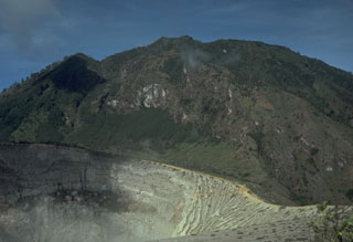
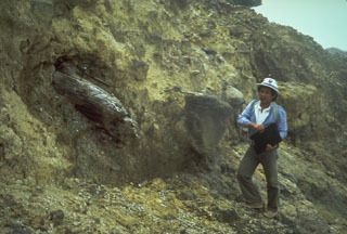
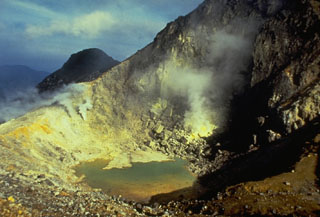
 Sulfur miners (left) extract sulfur from the crater walls of Kawah Ijen. Large baskets of sulfur are carried up to the crater rim and down its flanks. The sulfur factory is located at Jambu, on the SE flank above Banyuwangi.
Photo by Tom Casadevall, 1987 (U.S. Geological Survey).
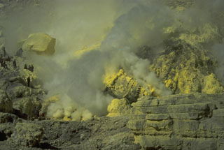
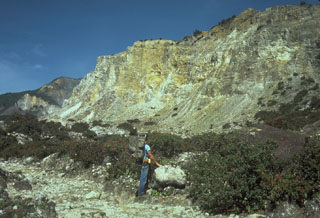
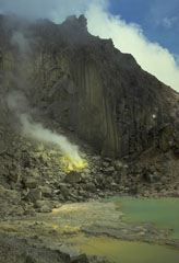
 Active fumaroles on the SE crater wall of the highly acidic Kawah Ijen crater lake, within one of the cones that formed in the 20-km-wide Ijen caldera. The 1-km-wide turquoise-colored crater lake is near the eastern rim of Ijen caldera and has been the site of phreatic eruptions in historical time and is noted for its sulfur deposits.
 Photo by Tom Casadevall, 1987 (U.S. Geological Survey).
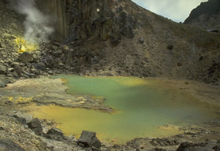
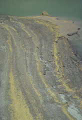 The yellow stripes in the foreground are strandlines of elemental sulfur particles that have been washed up on the shoreline of Kawah Ijen lake by wave action. The crater walls of Kawah Ijen have been the site of a long-term sulfur-mining operation.
Photo by Tom Casadevall, 1987 (U.S. Geological Survey).
 Kawah Ijen crater in the foreground is constructed on the flank of Gunung Merapi, the highest peak of the Ijen volcanic complex. Gunung Merapi, less known than the Merapi volcano of central Java, was constructed on the eastern rim of Ijen caldera.
Photo by Tom Casadevall, 1987 (U.S. Geological Survey).
 Lamongan volcano is located between the Tengger and Iyang-Argapura volcanic complexes. A cluster of 27 maars, many filled by lakes, and 37 scoria cones surround the volcano. Tarub is the volcano's highest peak to the left. Lamongan was frequently active during the 19th century, producing both explosive eruptions and lava flows.
Photo by Tom Casadevall, 1985 (U.S. Geological Survey).
 This lake-filled maar on the NE flank of Lamongan is one of 27 surrounding the volcano. Most historical eruptions have originated from the summit crater.
Photo by Tom Casadevall, 1987 (U.S. Geological Survey).
 The Gunung Anyar scoria cones were formed during an eruption in 1898 at 400 m elevation on the SW flank of Lamongan. The eruption began on 5 February. Activity slowed by the 7th, but the emission of two small lava flows continued, the largest of which traveled 300 m by the time it stopped on 15 February.
Photo by Tom Casadevall, 1987 (U.S. Geological Survey).
 Lamongan, a small volcano located between the massive Tengger and Iyang-Argapura volcanoes, rises above Lamongan Lake on its western flank. Ranu Lamongan lake fills one of 27 maars that surround the volcano, that have diameters ranging from 150 to 700 m. There have been frequent explosive eruptions, mostly from the summit crater, during the 19th century.
Photo by Tom Casadevall, 1985 (U.S. Geological Survey).
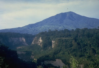
 Gunung Semeru rises above cultivated land to its south in this photo taken in 1986. The volcano is located at the southern end of the Mount Bromo-Tengger-Semeru National Park and has been near-continuously active since 1818.
Photo by Tom Casadevall, 1986 (U.S. Geological Survey).
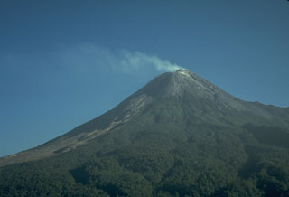
 Semeru volcano rises above the coastal plain in Java, shown here producing a small ash plume in 1985. Larger eruptions occasionally produce pyroclastic flows and lahars that reach as far as the lower flanks of the volcano. Semeru (also known as Mahameru: "Great Mountain") has been in near-continuous activity since 1818.
Photo by Tom Casadevall, 1985 (U.S. Geological Survey).
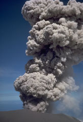 An explosive eruption at the summit crater of Semeru on 17 August 1985. This activity is typical of Semeru, which has been in near-continuous eruptive activity since 1818, producing frequent small-to-moderate explosions that eject ash and volcanic bombs. Some larger eruptions have produced pyroclastic flows and lahars that have reached the foot of the volcano.
Photo by Tom Casadevall, 1985 (U.S. Geological Survey).
 An eruption plume rises above the summit crater of Semeru on 17 August 1985. Semeru has been in near-continuous activity since 1818, producing frequent small-to-moderate explosions that eject ash and volcanic bombs. Some larger eruptions have produced pyroclastic flows and lahars that have reached the foot of the volcano.
Photo by Tom Casadevall, 1985 (U.S. Geological Survey).
 An aerial view from the WSW on 6 January 1987 shows a black lava flow descending from the summit crater of Merapi. During a five-day period beginning 10 October 1986, the dome was partially destroyed by a series of dome-collapse pyroclastic flows (block-and-ash flows). The period of dome growth and lava effusion seen in this photo then began and continued for several years before stabilizing in mid-1990.
Photo by Tom Casadevall, 1987 (U.S. Geological Survey).
 Merapi volcano, one of Indonesia's most active, rises above the city of Yogyakarta in central Java. This May 1987 view from the southern flank with the red-roofed Plawangan observatory on the forested ridge in the foreground shows Merapi's degassing summit lava dome. Unvegetated areas on the left result from periodic rockfalls, avalanches, and pyroclastic flows (block-and-ash flows) from the growing lava dome.
Photo by Tom Casadevall, 1986 (U.S. Geological Survey).
 A lava dome that was produced during 1972-1985 lies within the summit crater of Merapi volcano in central Java. A small spine appears on the right in this 4 July 1986 photo, which was taken during a period of inactivity prior to destruction of the dome on 10 October 1986. Historical eruptions have been characterized by repeated growth and collapse of the summit lava domes, periodically producing pyroclastic flows that have impacted communities on the western and southern flanks.
Photo by Tom Casadevall, 1986 (U.S. Geological Survey).
 A gas plume is blown to the west from the summit of Merapi volcano on 7 December 1986, accompanying growth of a new lava dome. Small-to-moderate explosive eruptions began in October 1972. Periodic collapse of the growing lava dome produced pyroclastic flows (block-and-ash flows) and lahars that damaged cultivated lands on the SW flank of the volcano.
Photo by Tom Casadevall, 1986 (U.S. Geological Survey).
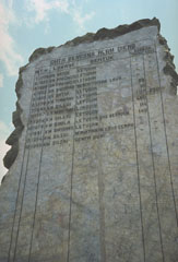 A stone monument is inscribed with a list of eruptions from the Dieng volcanic complex in central Java. The second column from the right lists fatalities (most recently 149 in 1979), which have occurred many times as a result of phreatic explosions and toxic gas emissions.
Photo by Tom Casadevall, 1986 (U.S. Geological Survey).
 More than three years after the end of the major eruption that began in 1982 the crater had partially been filled by a lake. The dark streaks are lahar deposits that swept into the lake as a result of remobilization of tephra deposits from the eruption. Vegetation has recovered on the steep background wall, which is the SW scarp of the 1-km-deep scar resulting from flank collapse.
Photo by Tom Casadevall, 1986 (U.S. Geological Survey).
 This 28 August 1986 photo from the SE rim of Warirang crater shows the small tip of the January 1983 scoria cone in the center of the lake, just before the cone was completely covered by rising lake waters. Black scoria from the 1982-83 eruption caps the rim of the crater.
 Photo by Tom Casadevall, 1986 (U.S. Geological Survey).
 The collapse of the summit of Papandayan volcano on 8 August 1772 produced a debris avalanche that swept over lowland areas to the east, destroying 40 villages and killing 2,957 people. The farmlands in the foreground of this photo are underlain by the deposits from this avalanche, which traveled 11 km from the volcano. The collapse event was accompanied by a 5-minute-long explosive eruption.
Photo by Tom Casadevall, 1986 (U.S. Geological Survey).
 The flat area to the left is Alun-Alun, the uppermost of four large craters on Papandayan volcano. The v-shaped valley in the center of the photo extending to the NE is the breach left by collapse of Papandayan volcano in 1772. The volcano in the distance on the left horizon is Gunung Guntur, another historically active volcano bordering the Garut Plain.
Photo by Tom Casadevall, 1986 (U.S. Geological Survey).
 The steep, hydrothermally altered scarp on the left is the headwall of the 1772 collapse of Papandayan, which produced a debris avalanche that traveled at high velocities up to 11 km from the volcano, destroying 40 villages and causing nearly 3,000 fatalities.
Photo by Tom Casadevall, 1986 (U.S. Geological Survey).
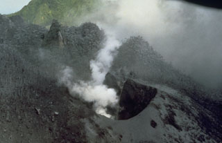
 A plume rises above the Kawah Mas thermal area in the crater of Papandayan volcano. This view from the NW shows Gunung Warirang at the left and the eastern wall of the Papandayan crater in the background. The 1772 debris avalanche traveled to the NE down the valley at the left.
 Photo by Tom Casadevall, 1986 (U.S. Geological Survey).
 The hydrothermally altered rocks of Welirang Ridge in the background is the NE scarp resulting from the partial flank collapse of Papandayan volcano in 1772. The extensive alteration of rocks within the volcano contributed to the collapse that produced a debris avalanche that traveled 11 km from the volcano, destroying 40 villages.
Photo by Tom Casadevall, 1986 (U.S. Geological Survey).
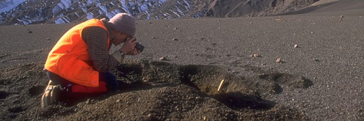
 A scientist from the Volcanological Survey of Indonesia examines a debris avalanche deposit at Papandayan volcano that predates the historic 1772 debris avalanche. The deposit contains large angular clasts in a hydrothermally altered matrix and the large log to the left.
Photo by Tom Casadevall, 1986 (U.S. Geological Survey).
 The broad Tangkuban Parahu, known locally as the mountain of the "upturned boat," dominates the skyline immediately N of Indonesia's former capital city of Bandung. The volcano is truncated by the 6 x 8 km Pleistocene Sunda caldera. A series of nine overlapping craters form a 1 x 1.5 km wide elliptical depression at the summit of the post-caldera cone. Minor phreatic eruptions have occurred in historical time.
Photo by Tom Casadevall, 1987 (U.S. Geological Survey).
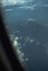 A commercial flight above the Padang Highlands of central Sumatra provides a view of a plume rising from the summit crater of Kerinci, Indonesia's highest volcano.
Photo by Tom Casadevall, 1987 (U.S. Geological Survey).
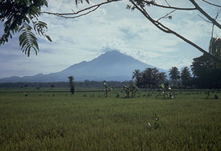
 Kerinci is Indonesia's highest volcano, and one of its most active, and is seen here above tea plantations to the south. A small plume rises from the unvegetated summit that has a cone containing a 600-m-wide summit crater over 400 m deep with a crater lake at the bottom. Frequent small-to-moderate explosive eruptions have occurred in historical time.
Photo by Tom Casadevall, 1987 (U.S. Geological Survey).
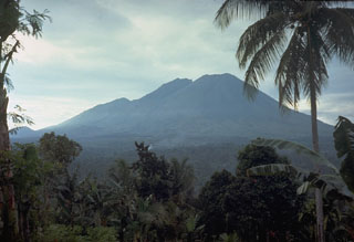
 The historically active Gunung Tandikat lies across the Bukittinggi Plain from Marapi volcano in central Sumatra. The summit of Tandikat's neighboring volcano, Singgalang, is seen here from Bukittinggi city across the steep-walled Ngarai canyon north of the volcano. Gunung Tandikat contains a central cone and a small crater lake constructed within a larger 1.2-km-wide crater. Small explosive eruptions have occurred recently, including in 1924.
Photo by Tom Casadevall, 1987 (U.S. Geological Survey).
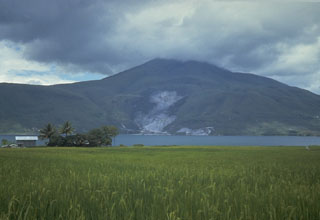
 Sorikmarapi, seen here from the west, is a forested stratovolcano with a 600-m-wide summit crater containing a crater lake and substantial sulfur deposits. Another crater lake is located on the upper SE flank and several small craters occur within the main crater and on the outer flanks. Small explosive eruptions have been documented from summit and flank vents in the 19th and 20th centuries.
Photo by Tom Casadevall, 1987 (U.S. Geological Survey).
 Clouds obscure the summit of Pusukbukit, a young volcano that formed on the western margin of Toba caldera. An active geothermal area forms the light-colored area at the base of the volcano across the strait from Samosir Island on Lake Toba.
Photo by Tom Casadevall, 1987 (U.S. Geological Survey)
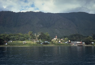 The steep wall behind Tomok village on Samosir Island is part of a block of uplifted caldera-fill rocks. The entire 630 km2 island, which now rises to 700 m above Lake Toba, is capped with lake-floor sediments that were deposited before the island was uplifted above lake level.
Photo by Tom Casadevall, 1987 (U.S. Geological Survey)
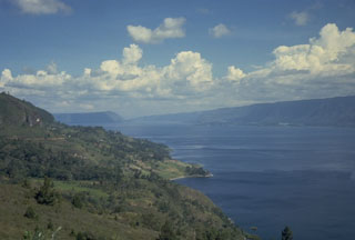
 The 35 x 100 km wide Toba caldera, partially filled by Sumatra's Lake Toba, is Earth's largest Quaternary caldera. This view looks W toward the northern end of Samosir Island, which is part of a block that was uplifted after eruption of the Young Toba Tuff (YTT) about 74,000 years ago. The island, once entirely covered by Lake Toba, is formed of caldera-fill deposits of YTT-capped by lake sediments.
Photo by Tom Casadevall, 1987 (U.S. Geological Survey)
 The 35 x 100 km Toba caldera was formed during four powerful explosive eruptions beginning 1.2 million years ago. The latest of these, about 74,000 years ago, was one of the world's largest known Quaternary eruptions, producing the Young Toba Tuff (YTT).
Photo by Tom Casadevall, 1987 (U.S. Geological Survey)
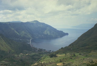 The northern wall of Toba caldera rises about 500 m above the village of Haranggoal. Samosir Island, visible in the distance across Lake Toba on the right, is part of an uplifted block of caldera-fill deposits from the last major eruption of Toba about 74,000 years ago.
Photo by Tom Casadevall, 1987 (U.S. Geological Survey)
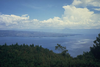
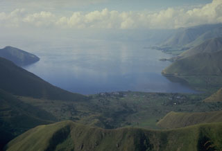 Lake Toba, the largest lake in SE Asia, fills more than half of the 35 x 100 km Toba caldera, the Earth's largest Quaternary caldera. The caldera walls rise steeply 400-1,200 m above the 1,700 km2 lake, which is one of the world's deepest with a maximum depth of 530 m. This view looks south from the northern caldera rim.
Photo by Tom Casadevall, 1987 (U.S. Geological Survey).
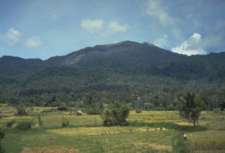
 The Sinabung volcano, seen here from the E, rises above farmlands on the Karo Plateau. At the time of this photo Sinabung contained four summit craters, the southernmost of which was the youngest. Many prominent lava flows can be seen on the flanks of the volcano.
Photo by Tom Casadevall, 1987 (U.S. Geological Survey).
 A crater containing a small turquoise-colored lake and active sulfur-coated fumaroles on the summit lava dome of Sibayak volcano. The volcano is considered to be the abode of Nini Kertah Ernala ("Grandmother of the Gleaming Sulfur"), the mountain's spirit.
Photo by Tom Casadevall, 1987 (U.S. Geological Survey).
 A small crater lake near the summit of Sibayak volcano shows active fumaroles and sulfur mineralization. An active fumarole is visible at the upper left. The lake is popular destination for weekend climbers from villages and towns surrounding the volcano.
Photo by Tom Casadevall, 1987 (U.S. Geological Survey).
 A 300-m-wide crater near the summit of Sibayak volcano contains a small turquoise-colored crater lake and areas of extensive hydrothermal alteration and sulfur mineralization. Plumes rise above active fumaroles at several locations along the far crater wall.
Photo by Tom Casadevall, 1987 (U.S. Geological Survey).
 Climbers along a path near the summit of Sibayak volcano. The horizontal forested ridge in the center background, forming part of the southern caldera wall of Singkut, is viewed from an area of hydrothermally altered rock near the summit.
Photo by Tom Casadevall, 1987 (U.S. Geological Survey).
 The ridge in the background of this photo is part of the wall of a caldera that contains Sibayak and Pinto volcanoes. The lower slope of Sibayak rises at the far right above the caldera floor, which is occupied by villages and agricultural land.
Photo by Tom Casadevall, 1987 (U.S. Geological Survey).
 A plume rises from a thermal area near the summit of Sibayak volcano within Singkut caldera. Sibayak is seen here from a village in the flat-floored caldera S of the summit.
Photo by Tom Casadevall, 1987 (U.S. Geological Survey).
 Sibayak and Mt. Pinto are located within the Singkut caldera in NE Sumatra. The slightly higher Pinto partially overtops the 900-m-wide crater of Sibayak to the N. The summit contains a lava dome and an area of hydrothermal alteration visible in this photo. An ash eruption from Sibayak was recorded in 1881, and nearby residents have legends of eruptions.
Photo by Tom Casadevall, 1987 (U.S. Geological Survey).