Theme Collections | Dick Stoiber Photos
Theme collections are galleries not specifically related to volcanic hazards, processes, research, types, or features. This includes subjects such as different satellite platforms, astronaut photos from the Space Shuttle, specific photographers, or other special collections.
Image Gallery for Dick Stoiber Photos
Richard "Dick" Stoiber graduated from Dartmouth in 1932 and went on to earn a Ph.D. in economic geology from MIT in 1937. He then returned to Dartmouth to work as a volcanologist and professor of geology from 1935 to 1989. He spent much of his later career studying volcanoes, their fumaroles and sublimates, in Central America, specifically Guatemala and El Salvador. In the mid-1960s he began organizing term-long trips to Central America for third-year Earth Science classes to study the geology of volcanoes. There are 40 images available.
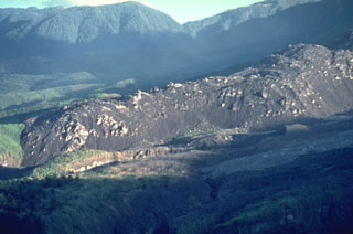
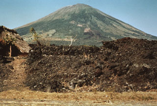 This barren lava flow issued from a fissure vent on the SE flank of San Miguel in 1819. The flow traveled about 5 km and covered a broad area below the SE base of the volcano, extending down to 25 m above sea level. Emplacement of the lava flow necessitated the construction of a new road at the base of the volcano.
Photo by Dick Stoiber, 1971 (courtesy of Bill Rose, Michigan Technological University).
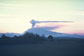
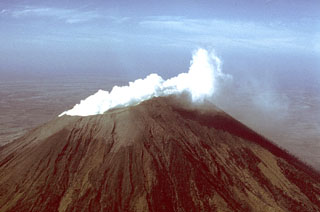
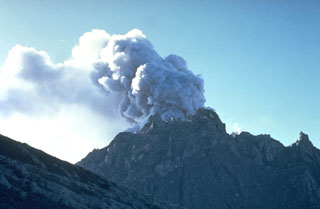
 A vigorous steam plume pours from the summit crater of San Cristóbal volcano in December 1971, following an eruption that began on May 3. This mild explosive eruption lasted until early July. The 1971 activity marked the first documented eruptive activity at San Cristóbal since the 17th century. The volcano is seen here from the El Limón gold mine east of the volcano.
Photo by Dick Stoiber, 1971 (Dartmouth College).
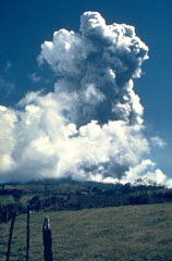
 An ash plume above the summit of Irazú is seen in March 1963 from the old San José airport. Eruptions during 1963-65 were among the largest in historical time from the volcano. Intermittent mild-to-moderate explosive activity produced heavy ashfall that severely affected agricultural areas and caused economic disruption.
Photo by Dick Stoiber, 1963 (Dartmouth College).
 The first of several major eruptions of Irazú between 1963 and 1965 took place on 13 March 1963. These eruptions produced heavy ashfall over much of central Costa Rica, severely affecting agricultural areas and causing major economic problems. Lahars caused fatalities and destroyed hundreds of houses.
Photo by Dick Stoiber, 1963 (Dartmouth College).
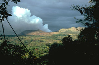 Masaya volcano is noted for long-duration periods of voluminous gas emission. This February 1982 photo from the NE shows a gas plume pouring from Santiago crater, during the 4th gas emission crisis of the 20th century. Emission of a very large gas plume had continued without interruption since the fall of 1979. Remote sensing of SO2 revealed continued high level flux, with a 1500-2000 tons/day average during 1980. Distribution of the gas plumes by prevailing winds caused widespread crop damage.
Photo by Dick Stoiber, 1982 (Dartmouth College).
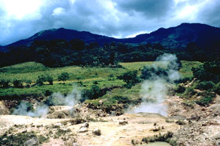
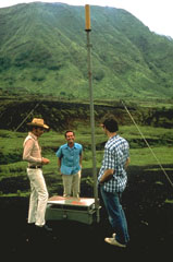 Early monitoring efforts at Masaya volcano included tilt meter stations such as this one, operated by the Instituto Nicaragüense de Estudios Territoriales (INETER). Inflation of the volcano's surface produced by ascent of magma can be detected by sensitive instruments such as the one installed here in 1976.
Photo by Dick Stoiber, 1976 (Dartmouth College).
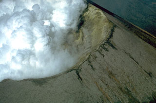
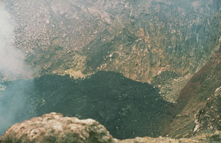 Fresh black lava fills the floor of Santiago crater in December 1976. A new lava lake appeared on the floor of Santiago Crater on October 20, 1965, marking the beginning of Masaya's third 20th-century lava lake cycle. Several lava flows occurred on the crater floor between 1965 and 1972. The spatter cone collapsed in 1972 and lava lake activity was visible until 1979, when the lava lake subsided, producing thick gas emissions.
 Photo by Dick Stoiber, 1976 (Dartmouth College).
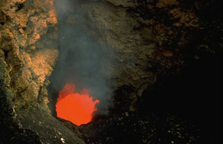 An incandescent vent glows on the floor of Santiago crater in July 1972. A new lava lake formed in Santiago crater in October 1965. By 1969 activity was restricted to a small spatter cone; after it collapsed in 1972 a lava lake was visible until 1979. Periodic lava lake activity has occurred since the time of the Spanish Conquistadors. The partially yellow incandescence of the active lava lake was taken for molten gold, prompting several attempts to mine it.
Photo by Dick Stoiber, 1972 (Dartmouth College).
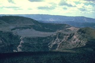 Three Masaya summit craters are visible in this view to the NW; Santiago crater appears in the foreground, with the flat, high surface of Nindirí crater in the middle and San Pedro crater behind it. The flat-lying, lighter-colored lavas in the center are a part of a lava lake emplaced in Nindirí crater during an eruption in July 1852. A small lava flow was also emitted at that time, a few years before the formation of Santiago and San Pedro pit craters in 1858-1859. The NW wall of Masaya caldera forms the low ridge in the middle distance.
Photo by Dick Stoiber, 1963 (Dartmouth College).
 The southern side of Las Pilas volcano is cut by a prominent transverse fissure, seen steaming in this 1970 view from the SW. A small circular pit crater, El Oyo, is located above the fissure just below the crater rim. Aside from a possible eruption in the 16th century, the only historical eruptions of Las Pilas took place in the 1950s from a fissure that extended across the east side of the 700-m-wide summit crater and down the north flank.
 Photo by Dick Stoiber, 1970 (Dartmouth College).
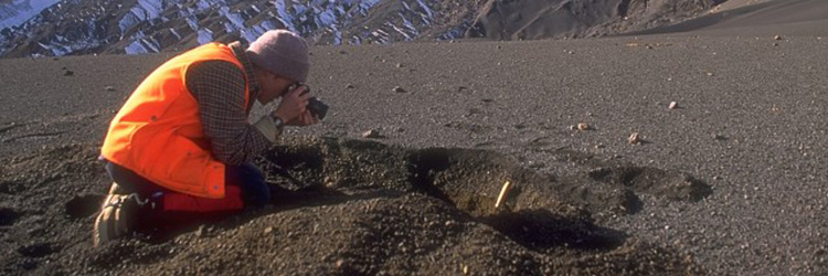
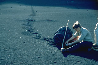 Volcanologist Bill Rose measures a large bomb ejected during the 1971 eruption of Cerro Negro volcano. The bomb landed on the flank of the cinder cone and rolled across the surface of fresh ash. The 1971 eruption took place February 3-14. Heavy ashfall produced extensive crop damage. This photo was taken in March 1971.
Photo by Dick Stoiber, 1971 (Dartmouth College).
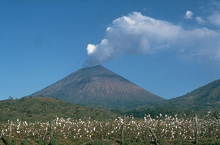
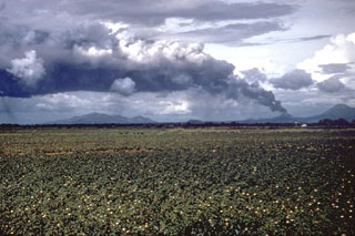 A large tephra cloud silhouetted against weather clouds rises from Cerro Negro volcano in November 1968. Strong winds blowing from the east deflect the ash plume. This view from the SW looks across cotton fields of the Nicaraguan central depression to the Marrabios Range volcanoes. To the right of Cerro Negro is Las Pilas volcano, and the broad massif to the left is Rota volcano.
Photo by Dick Stoiber, 1968 (Dartmouth College).
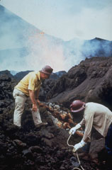 Scientists sample fumaroles near the flank vent at Cerro Negro in November 1968. Incandescent spatter is ejected from the vent in the background behind volcanologist Dick Stoiber (left), who led many expeditions from Dartmouth College to Central American volcanoes. This fumarole was a source of tenorite (CuO) and other minerals.
Photo by Dick Stoiber, 1968 (Dartmouth College).
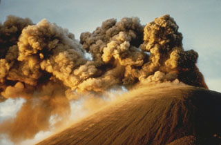 Strong winds deflect ash plumes from a strombolian eruption at the summit crater of Cerro Negro on November 8, 1968. This photo was taken from the south about two weeks after an eruption that began with flank activity on the night of October 23. The following day eruptions began from the summit crater. Plumes rose 1000-1500 meters, and heavy ashfall distributed by winds primarily to the west damaged 700 km2 of croplands. The eruption lasted until December 15.
Photo by Dick Stoiber, 1968 (Dartmouth College).
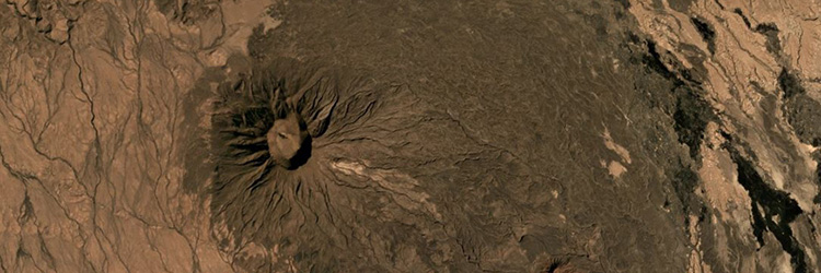
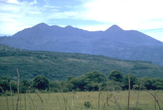
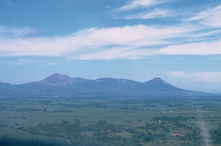 This low-angle aerial view from the south shows the profile of the Telica volcanic complex, which consists of several interlocking cones and vents with a general NW alignment. Telica itself, the high peak at the left, is a steep-sided cone with a 700-m-wide double crater. El Liston, immediately E of Telica (at center), has several nested craters. Santa Clara volcano is the symmetrical cone at the right.
Photo by Dick Stoiber, 1972 (Dartmouth College).
 Steam clouds fill much of the crater of San Cristóbal volcano in March 1976. After a quiescence of about five years, small ash eruptions took place at San Cristóbal on March 9-10, 1976, dropping ash on the nearby town of Chinandega. During an eruption on March 16 ash was confined primarily to the summit crater area. The summit crater of San Cristóbal is 500-600 m wide.
Photo by Dick Stoiber, 1976 (Dartmouth College).
 A vigorous white steam plume, seen here from the NW, rises from the summit crater of San Cristóbal volcano in March 1976. Small ash eruptions occurred from San Cristóbal on March 9-10, 1976, dropping ash on the town of Chinandega, 10 km to the SW. Ashfall from another eruption on March 16 was restricted to the summit crater area. Collapse of cones within the summit crater during this eruption created a new 300-m-wide vent.
Photo by Dick Stoiber, 1976 (Dartmouth College).
 A strong steam plume pours from the summit crater of San Cristóbal volcano in this March 1976 view from the NW. Mild explosive eruptions during March 9-16, 1976 were the first since 1971. In February 1972 part of the crater floor began subsiding, ultimately leading to formation of a collapse pit in March 1976. By December 1976 the pit had deepened to 90 m and incandescence was visible after dark.
Photo by Dick Stoiber, 1976 (Dartmouth College).
 The profile of Cosigüina is not particularly impressive when viewed from its NE flank along the coast of the Gulf of Fonseca near the town of Potosí. The broad low-angle slopes of Cosigüina rise only 872 m above the coast and give little hint of the dramatic caldera that cuts the summit. Pyroclastic flows from the 1835 eruption reached the northern coast of the 20-km-wide Cosigüina Peninsula and formed new ephemeral islands in the Gulf of Fonseca.
Photo by Dick Stoiber, 1978 (Dartmouth College).
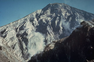
 The summit of San Miguel volcano contains a deep crater whose morphology has been frequently modified by historical eruptions. In 1586 the volcano already had a truncated summit; before then the volcano was said to have had a sharp peak. In 1866 the crater was 600 m wide and 320 m deep and contained a subcrater on the ENE side. A cinder cone that formed at the NE side of the crater in 1884 had largely disappeared by 1924, and a ring plain on the crater floor was largely gone by 1949.
Photo by Dick Stoiber, 1965 (Dartmouth College).
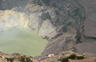 The inner crater of Santa Ana is 500 m wide and is partially filled by a 250-m-wide greenish crater lake in this 1966 photo. Fumaroles are active on the crater wall and in the lake, and abundant sulfur deposits are located on the SW wall (upper left). The acidic crater lake has a pH of about 1, and bathymetric surveys have revealed a maximum depth of 27 m.
Photo by Dick Stoiber, 1966 (Dartmouth College).
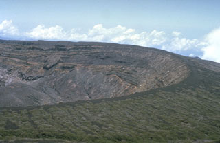 The broad summit of Santa Ana volcano has a 1.5-km-wide crater seen here from the south. The series of bedded phreatomagmatic tephra layers exposed in the crater wall in this photo form the summit region and overlie lava flows exposed lower in the crater walls.
Photo by Dick Stoiber, 1966 (Dartmouth College).
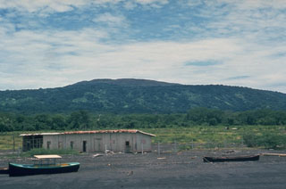
 The Ahuachapán geothermal area on the NW flank of Laguna Verde has been used for power generation since 1975. It is one of the most recent manifestations of activity in a group of Pleistocene and Holocene volcanoes comprising the Cuyanausul Range. The Cerro El Aguila and Cerro Los Naranjos volcanoes at the eastern end are Holocene in age. A 1990 steam explosion from the Ahuachapán thermal area resulted in fatalities.
Photo by Dick Stoiber, 1962 (Dartmouth College).
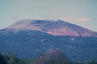
 The Pacaya volcanic complex is seen here from the north. The rounded Cerro Grande lava dome forms the high point to the left. The peak to the right is the historically active cone of Pacaya. It was constructed within an arcuate crater whose rim forms the flat ridge on either side of the cone. This September 1962 photo was taken prior to a long-term eruption beginning in 1965 from a new vent on the western flank. Frequent eruptions built MacKenney cone, which grew to the height of the previous cone.
Photo by Dick Stoiber, 1962 (Dartmouth College).
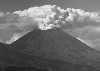
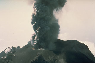 An ash plume rises from the summit crater of Fuego in this March 1978 photo. Intermittent minor explosive eruptions took place from 11 September 1977 to 8 August 1979. The eruptions sometimes produced pyroclastic flows and lava flows, and originated from multiple vents in the summit crater.
Photo by Dick Stoiber, 1978 (Dartmouth College).
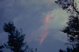 An ash plume with incandescent ejecta rises high above the summit of Fuego and produces hot avalanches down its flanks during this 12-13 August 1966 eruption. Ash fills much of the sky in this view. The ash plume rose to 12 km during this large but brief eruption.
Photo by Dick Stoiber, 1966 (Dartmouth College).
 A small block-and-ash flow produced by a small collapse of the growing lava dome descends about 750 m down the north flank of El Brujo dome on 7 July 1967. The Pacific coastal plain is visible in the distance. El Brujo was the westernmost dome of the compound Santiaguito lava dome, which extends about 3 km in a roughly E-W direction.
Photo by Dick Stoiber, 1967 (Dartmouth College).
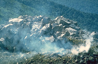 A small blocky lava dome within the Caliente vent on the Santiaguito lava dome of Guatemala's Santa María volcano on 18 July 1969. This was near the beginning of a period of renewed activity at this vent. Growth of the composite Santiaguito lava dome has been ongoing since 1922.
Photo by Dick Stoiber, 1969 (Dartmouth College).
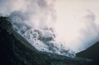 A pyroclastic flow produced by collapse of a growing lava dome descends the northern flank of the Santiaguito lava dome in November 1967. Periodic larger collapses of Santiaguito have sent pyroclastic flows down the populated southern flanks. The most catastrophic of these traveled 10 km in 1929, when hundreds to thousands of people were killed.
 Photo by Dick Stoiber, 1967 (Dartmouth College).
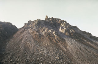 El Brujo vent at the western end of the Santiaguito lava dome complex was the youngest vent when this 10 August 1967 photo was taken from the north. The dome was not yet present in February 1954 aerial photographs, and may have begun growing following a strong explosive eruption on 14 April 1956. A large lava flow was extruded during 1959-63.
 Photo by Dick Stoiber, 1967 (Dartmouth College).
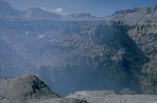
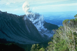
 The interior of a stratovolcano is dramatically revealed in a 1-km-wide crater created on the SW flank of Guatemala's Santa María volcano during an eruption in 1902. The 1,200-m-high scarp exposes thin, light-colored lava flows that are interbedded with deposits of fragmented rock produced during growth of the volcano. The 1902 eruption was one of the world's largest during the 20th century.
Photo by Dick Stoiber, 1969 (Dartmouth College).
 A dacitic lava flow that traveled to the SW from El Brujo vent of Santiaguito is seen in April 1963, a month after it ceased flowing. The slow-moving lava flow is approximately 50 m thick and extended about 1.5 km from the vent. El Brujo, near the western end of the Santiaguito dome complex of Guatemala's Santa María volcano, is the youngest at Santiaguito and was the focus of increased effusive activity from 1959 to 1963.
Photo by Dick Stoiber, 1963 (Dartmouth College).
 An ash plume rises above the Caliente vent in February 1968. Lava spines protrude from the easternmost vent of the Santiaguito lava dome. The flank of the Santa María edifice appears to the left in this view from the north.
Photo by Dick Stoiber, 1968 (Dartmouth College).
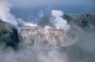 A lava dome fills Caliente crater at the eastern end of the Santiaguito dome complex in June 1968. Gases rise from fumaroles along the margins of the roughly 100-m-wide crater in this view from the north. Periodic ash eruptions accompanied growth of the dome. The Caliente vent is in the oldest part of the Santiaguito dome complex, which began erupting in 1922. It was the source of a major explosive eruption in 1929 that produced large pyroclastic flows.
Photo by Dick Stoiber, 1968 (Dartmouth College).
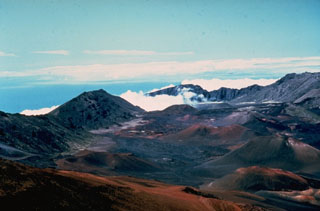 The summit of Haleakalā on the island of Maui contains a large crater that opens towards the ENE. It formed by the erosion of two large valleys that eventually coalesced, along with collapse events. This view to the NE from near the summit shows the Ko’olau Gap in the distance and scoria cones on the crater floor from eruptions along a major rift zone that extends across the summit from the SW to eastern coasts.
Photo by Dick Stoiber, 1976 (Dartmouth College).
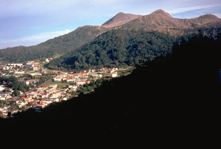 Usu volcano is a located on the southern topographic rim of the 110,000-year-old Toya caldera. The summit, seen here above the town of Toyako-Onsen to the NW, consists of dacitic lava domes and a cryptodome that were emplaced in a small summit caldera during historical eruptions.
Photo by Dick Stoiber, 1981 (Dartmouth College).
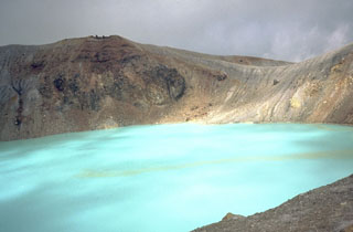 The turquoise waters of Yugama, one of three craters at the summit of Japan's Kusatsu-Shirane volcano, are a popular tourist destination. Yellow rafts of sulfur float on the surface of the acidic lake, which prior to an eruption in 1882, was clear with forested walls. Frequent phreatic explosions have occurred from Yugama and the two other summit craters during historical time. This 1981 photo was taken from the south crater rim.
Photo by Dick Stoiber, 1981 (Dartmouth College).
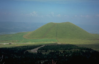 Kometsuka scoria cone, on the NW side of the central cone complex of Aso volcano on the island of Kyushu, was constructed about 1,800 years ago. The cone formed during explosive eruptions that were accompanied by lava flows. The Aso caldera walls are visible in the distance.
Photo by Dick Stoiber, 1981 (Dartmouth College).
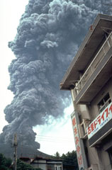 An ash plume rises above a restaurant on Sakurajima island in September 1981. Near-continuous periods of explosive eruptions have been occurring since 1955, frequently depositing ash on residential areas. Occasional larger explosions have ejected ballastic blocks that have penetrated concrete roofs of buildings. Villages are located along the island's coast, but most are only 3-5 km from the active Minamidake summit crater.
Photo by Dick Stoiber, 1981 (Dartmouth College).
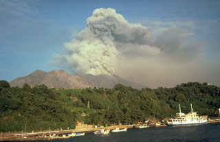 Sakurajima entered a period of frequent intermittent moderate explosions in October 1955. Ashfall from the active vent at Minamidake has often deposited ash on Kagoshima, southern Kyushu's largest city located 7 km across the bay. Ash plumes typically reach heights of 1-3 km above the vent. Lahars and ballistic block ejection have intermittently affected populated areas on the island. This September 1981 view shows an ash plume from the W.
Photo by Dick Stoiber, 1981 (Dartmouth College).