Report on Patah (Indonesia) — May 1989
Scientific Event Alert Network Bulletin, vol. 14, no. 5 (May 1989)
Managing Editor: Lindsay McClelland.
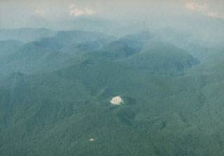
Patah (Indonesia) Overflight shows gas emission from 150-m crater
Please cite this report as:
Global Volcanism Program, 1989. Report on Patah (Indonesia) (McClelland, L., ed.). Scientific Event Alert Network Bulletin, 14:5. Smithsonian Institution. https://doi.org/10.5479/si.GVP.SEAN198905-261231
Patah
Indonesia
4.257°S, 103.306°E; summit elev. 2836 m
All times are local (unless otherwise noted)
On 1 May, M.S. Savill, pilot of a British cargo aircraft, photographed an apparent new crater in rugged, heavily forested terrain at ~2,500 m altitude [around 4.30°S, 103.32°E, ~6 km SE of Patah]. The crater was described as a smoking feature ~150 m across on a ridge that is usually obscured by clouds. There was no evidence of a lava flow. VSI reported no observations of activity in the area.
The reported location of the new vent is ~7 km W of Bukit Ringgit II (Zen, 1973), and ~25 km W of Marga Bayur, which had a small phreatic eruption in 1940 [but see 14:9]. Dempo, ~45 km to the NW, has erupted more than 20 times since the early 19th century. The Tanjung Sakti hot springs and fumarole fields, on the S flank ~10 km from Dempo's summit, include six hot/boiling springs that emit white fume at temperatures ranging from 95°C to boiling.
References. Zen, M.T., 1973, IAVCEI Data Sheets of the Post-Miocene Volcanoes of the World.
Geological Summary. Patah is a heavily forested, dissected Quaternary volcano SE of Dempo volcano. The age of its latest eruptions is not known, although on 1 May 1989 a possible new 150-m-wide crater with active fumaroles was observed by a cargo aircraft pilot in a heavily forested area on the side of a small cone about 3 km SE of Gunung Patah. The exact date of its formation, and its geologic relationship to Patah are uncertain. A crater lake at the summit of another peak, Bukit Belirang (Sulfur Hill), is located 1.5 km S of the fumaroles.
Information Contacts: I. Gass, Open Univ; VSI.