Report on Tupungatito (Chile-Argentina) — October 1988
Bulletin of the Global Volcanism Network, vol. 13, no. 10 (October 1988)
Managing Editor: Lindsay McClelland.
Tupungatito (Chile-Argentina) Volcano-seismic trigger for 1987 debris flow disputed
Please cite this report as:
Global Volcanism Program, 1988. Report on Tupungatito (Chile-Argentina) (McClelland, L., ed.). Bulletin of the Global Volcanism Network, 13:10. Smithsonian Institution. https://doi.org/10.5479/si.GVP.BGVN198810-357010
Tupungatito
Chile-Argentina
33.425°S, 69.797°W; summit elev. 5660 m
All times are local (unless otherwise noted)
The following is from Alfredo Eisenberg and M. Pardo. "González-Ferrán (13:6) attributed the 29 November 1987 debris flow to an increase in local shallow volcano-seismic activity that he said can be observed on our seismograms of 28, 29, and 30 November. The seismic network in central Chile did not record any activity of this kind during those days, nor the previous ones. It is also important to note that only one station is located within 40 km of Tupungatito volcano's main crater (figure 3 and table 1). Stations on the Argentine side of the Andes did not register any volcano-seismic activity either. We did record the debris fall, however, at 1033 on 29 November, with an equivalent local magnitude of 4.5. This event, as far as we can see from the records, was not preceded by a triggering earthquake."
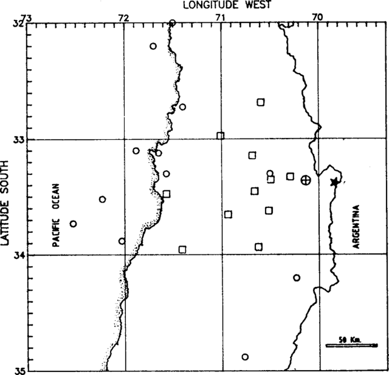 |
Figure 3. Seismicity in central Chile, 27-30 November 1987. Circles mark epicenters of located earthquakes (table 1), squares the position of seismological stations. The source of the debris flow is marked by a circled cross, and Tupungatito volcano by a star. |
Table 1. Seismicity recorded in central Chile, 27-30 November 1987, by Univ of Chile seismograph stations. Magnitude mt corresponds to an estimation of mb from the total duration of the PEL station record.
| Date | Time | Latitude | Longitude | Depth (km) | Magnitude (mt) |
| 27 Nov 1987 | 1038 | 33°31'S | 72°14'W | 50 | 4.3 |
| 27 Nov 1987 | 1130 | 33°07'S | 71°39'W | 18 | 4.1 |
| 28 Nov 1987 | 0916 | 33°44'S | 72°32'W | 10 | 4.1 |
| 28 Nov 1987 | 2153 | 33°18'S | 70°30'W | 75 | 3.7 |
| 29 Nov 1987 | 0214 | 34°12'S | 70°14'W | 00 | 3.7 |
| 29 Nov 1987 | 0332 | 33°53'S | 72°02'W | 20 | 4.5 |
| 29 Nov 1987 | 0807 | 33°06'S | 71°53'W | 27 | 4.4 |
| 30 Nov 1987 | 0010 | 32°43'S | 71°24'W | 5 | 4.0 |
| 30 Nov 1987 | 0637 | 33°18'S | 71°34'W | 23 | 4.2 |
| 30 Nov 1987 | 1055 | 34°53'S | 70°46'W | 109 | 4.3 |
| 30 Nov 1987 | 1325 | 32°00'S | 71°30'W | 28 | 4.1 |
| 30 Nov 1987 | 1510 | 32°12'S | 71°42'W | 28 | 4.1 |
Geological Summary. Tupungatito volcano, the northernmost historically active volcano of the central Chilean Andes, is located along the Chile-Argentina border about 90 km E of Santiago and immediately SW of the Pleistocene Tupungato volcano. Tupungatito consists of a group of 12 Holocene andesitic and basaltic andesite craters and a pyroclastic cone at the NW end of the 4-km-wide, Pleistocene dacitic Nevado Sin Nombre caldera, which is filled by glaciers at its southern end and is breached to the NW. Lava flows from the northernmost vent have traveled down the NW flank breach. Tupungatito has produced frequent mild explosive eruptions during the 19th and 20th centuries.
Information Contacts: A. Eisenberg and M. Pardo, Univ of Chile.