Report on Kelud (Indonesia) — January 1990
Bulletin of the Global Volcanism Network, vol. 15, no. 1 (January 1990)
Managing Editor: Lindsay McClelland.
Kelud (Indonesia) Explosive eruption produces heavy tephra falls, pyroclastic flows, and lahars; more than 30 people killed
Please cite this report as:
Global Volcanism Program, 1990. Report on Kelud (Indonesia) (McClelland, L., ed.). Bulletin of the Global Volcanism Network, 15:1. Smithsonian Institution. https://doi.org/10.5479/si.GVP.BGVN199001-263280
Kelud
Indonesia
7.935°S, 112.314°E; summit elev. 1730 m
All times are local (unless otherwise noted)
A strong explosive eruption on 10 February produced a large cloud and heavy tephra falls. Although evacuation began before the onset of the eruption, more than 30 people were reported killed in the densely populated area near the volcano.
Local seismicity increased to ~10x the normal rate between the middle and end of November, then returned to background levels. A second episode of increased seismicity occurred during the second and third weeks of January, accompanied by a rise in crater lake temperature from 32 to 38°C. Enhanced earthquake activity was again detected 7 February, and lake temperature peaked at 39-41°C. Measurements on 8 February indicated that lake pH had decreased to 4.2 from its usual 4.9, and hydrophones in the lake recorded noise at 3x normal levels. However, seismicity and hydrophone noise declined that day and remained relatively quiet until the onset of the eruption. During the night of 9-10 February, transmission from the lake instruments (via the ARGOS satellite) ceased. VSI issued an evacuation warning on 10 February at 1000. Press sources estimated the number of evacuees at 60,000.
The eruption began 10 February at 1141, with the strongest explosive phase at 1250, and activity continued until 1700. Pyroclastic flows traveled [5-6] km down the steep-walled valley on the E flank (from the breach in the summit crater), filling it to a depth of ~10 m. The crater lake was emptied during the eruption. However, most of the damage and casualties were attributed to heavy tephra falls that reached 20-30 cm thickness. In Nglegok (~55 km SW of the volcano) residents reported falls of fist-sized tephra, with some material that was head-sized. About 15 cm of ash accumulated at Blitar, ~25 km SW of the summit. Ashfalls were also reported from Malang, ~35 km E of Kelut. The weight of the tephra caused houses to collapse, trapping their occupants. As of 20 February, the official death toll had risen to 32, with >500 homes and 50 schools destroyed and many others damaged.
Tracking of the plume by satellite was made difficult by heavy weather cloud activity in the area. Imagery from Japan's GMS satellite at 1300 showed a bright cloud 53 km across centered over the volcano. At 1347, a NOAA polar orbiter image revealed that the plume, still roughly circular and centered over the volcano, had grown to ~160 km in diameter. Preliminary temperature analysis suggested that the top of the dense cloud was at ~12 km altitude, although diffuse material could have extended higher. By 1600, GMS data indicated that the plume had drifted slightly WSW and was ~310 km long. Very diffuse-appearing material could be seen extending to the NW coast of Australia, ~1,400 km from Kelut, on a NOAA polar orbiter image the next day at 1347. Dispersed remnants of the plume could be traced on GMS images until 1900.
Small explosions with associated glow and/or lightning were continuing during the night of 11-12 February, accompanied by strong seismic activity. A second strong explosive episode occurred between 1512 and 1827 on 12 February. Incandescent tephra rose 7 km above the crater. Rains triggered a major lahar on 15 February that moved downslope at 40-60 km/hour, inundating parts of subdistricts ~16 km NNW (Kepung) and 17 and 28 km NW (Ploso Klaten and Guran) of the summit, forcing residents to flee to high ground. Further heavy rains during the night of 16-17 February forced 50,000 Kepung subdistrict residents to flee. Minor eruptive activity for ~2 hours that night sent thick ash clouds to ~600 m above the vent. Additional lahars the next day moved downslope at ~45 km/hour, destroying hundreds of hectares of agricultural land.
Further Reference. Sudradjat, Adjat, 1991, A preliminary account of the 1990 eruption of the Kelut volcano: Geol. Jahrbuch, v. A127, p. 447-462.
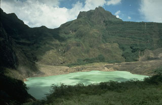
Geological Summary. The relatively inconspicuous Kelud stratovolcano contains a summit crater lake that has been the source of some of Indonesia's most deadly eruptions. A cluster of summit lava domes cut by numerous craters has given the summit a very irregular profile. Satellitic cones and lava domes are also located low on the E, W, and SSW flanks. Eruptive activity has in general migrated in a clockwise direction around the summit vent complex. More than 30 eruptions have been recorded since 1000 CE. The ejection of water from the crater lake during the typically short but violent eruptions has created pyroclastic flows and lahars that have caused widespread fatalities and destruction. After more than 5,000 people were killed during an eruption in 1919, an engineering project to drain the crater lake lowered the surface by more than 50 m. The 1951 eruption deepened the crater by 70 m, leaving 50 million cubic meters of water after the damaged drainage tunnels were repaired. Following more than 200 deaths in the 1966 eruption, a new deeper tunnel was constructed, and the lake's volume before the 1990 eruption was only about 1 million cubic meters.
Information Contacts: VSI; Y. Sawada, JMA; O. Karst, SAB; U.S. Embassy, Jakarta; T. Casadevall, USGS; Jakarta Post; UPI.