Report on Redoubt (United States) — January 1990
Bulletin of the Global Volcanism Network, vol. 15, no. 1 (January 1990)
Managing Editor: Lindsay McClelland.
Redoubt (United States) Month-old lava dome destroyed by strong explosions; 3rd, small dome removed by new explosions six days later
Please cite this report as:
Global Volcanism Program, 1990. Report on Redoubt (United States) (McClelland, L., ed.). Bulletin of the Global Volcanism Network, 15:1. Smithsonian Institution. https://doi.org/10.5479/si.GVP.BGVN199001-313030
Redoubt
United States
60.485°N, 152.742°W; summit elev. 3108 m
All times are local (unless otherwise noted)
AVO's detailed summary of the eruption through late January appears in the 13 February issue of EOS, accompanied by a second paper on satellite observation of the December plumes (see References, below).
Airfall tephra. Initial tephra studies suggest that airfall deposits have been relatively modest. At 8-11 km from the crater, most sectors showed 4-6 or more tephra layers in the snowpack, from <1 to 20 cm thick. One of the 15 December explosions generated pumiceous tephra, including fist-sized bombs that melted their way into the snow. Other explosive episodes appeared to have been dominated by accretionary lapilli and fine lithic ash.
8 January plume data. A monitoring aircraft operated by the Univ of Washington reached the 8 January plume about 2 1/2 hours after the onset of activity. Dimensions of the plume were measured with upward-looking lidar over the Kenai Peninsula (60.96°N, 151.17°W to 60.81°N, 150.02°W) between 1246 and 1257. The base of the plume was at about 3.85 km altitude and its top at 9.0-9.7 km, with the main mass of material at approximately 6.4 km. Mass median diameter of particles was about 7 µm. Inter-eruptive emissions monitored from the same aircraft before 8 January were SO2-rich, perhaps totaling several thousand metric tons/day, but attempts to collect COSPEC data failed because of low sun angles.
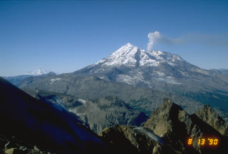
Lava extrusion and minor venting, mid January-mid February. A new lava dome was first seen during an overflight on 18 January, although seismic evidence suggested the onset of extrusion by 13 January, before the 16 January explosion. Vigorous vapor emission limited observations of the dome in late January, and growth was difficult to discern. Rockfalls off the dome were extensive, but no new lobes or fissures were evident. It appeared to be slightly less than 100 m high and roughly 1/4-1/3 the size of the late December dome, which had an estimated volume of 25 x 106 m3. Additional breakage of the glacier that remained above the vent was indicated by new crevasses and ice avalanches into the crater. Ice blocks descended in stairstep fashion toward the dome from a vertical icewall. Most of the vapor emission originated from the area between the ice and the dome, obscuring the near-dome region and the interaction between ice and lava. A stream of meltwater flowed from the crater.
A minor seismic event began at 2315 on 7 February and lasted for about 20 minutes, suggesting vigorous steam venting. It was detected only by the summit station, indicating that little if any ash was ejected. The dome appeared nearly unchanged during an overflight the next day. Shallow earthquake activity recorded near the summit increased 12 February, suggesting a higher rate of dome growth. A tremor-like episode on the seismic station nearest the summit began at 0305 on 13 February and lasted nearly 30 minutes. The seismicity was probably associated with vigorous gas venting, perhaps including a little ash. Shallow summit-area seismicity declined somewhat that day, but remained elevated, as dome growth apparently continued.
Explosive episode, 15 February. A moderately large explosive episode that began at 0403 on 15 February produced a steam and ash column that rose to more than 10 km altitude and was carried rapidly SE by 160 km/hour winds. A spectacular display of lightning and thunder that lasted for about an hour awakened many people on the Kenai Peninsula. Satellite data 7 minutes after the onset of explosive activity showed a possible low-level pyroclastic flow or surge extending 7-10 km from the crater on Redoubt's NW quadrant. The temperature of the warmest 1 x 1 km pixel in this area was +25°C, with ambient air reported below -10°. By 0500, satellite images showed a plume extending about 120 km SE with an average width of more than 70 km. Plume temperatures of -49°C yielded an estimated altitude of 10.5-11.5 km for the top of the dense portion of the cloud. Airline pilots reported ash to 12 km altitude in the Homer area (roughly 120 km SE of Redoubt) and more than 1 cm of ash on Homer's airport runway. Anchorage's international airport remained open, but the FAA warned aircraft to avoid the area near the volcano. Most personnel were evacuated from the Drift River oil facility, but the 4 remaining crew members reported an increased flow of silty water in both the Drift River and Rust Slough, a small-capacity stream W of the oil facility into which much of the Drift River's flow was diverted by earlier mudflow-induced channel changes. The seismic station nearest the summit was destroyed, presumably by lightning, but seismicity decreased to low levels on flank stations 18 minutes after the onset of the eruption.
An overflight the next day revealed that at least 75% of the lava dome had been destroyed. Pyroclastic flows had swept across the glacier's Piedmont lobe, and had entered small, previously unaffected drainages. A pyroclastic surge had moved about 2500 m up the N wall of the steep canyon that leads from Redoubt's breached crater. Flood deposits, slightly less extensive than those of 2 January, were primarily dark brown sediment, locally containing abundant 1-2 m boulders. Water had flowed around an L-shaped levee on the upriver side of the oil facility, and a small amount of water had penetrated the containment dike protecting the southernmost of the facility's 7 storage tanks, but no oil was spilled. Aerial observations on 18 February showed that a small new dome, with a volume of less than 1 x 10⁶ m3, had begun to grow in the vent area. [See also 15:2].
Explosive episode, 21 February. Another vigorous explosion occurred on 21 February, beginning at [0032] and lasting for about [12] minutes. Winds carried the plume rapidly NE, and by 0300 satellite images showed its front 700 km from the volcano, where it was about 80 km wide. Pilots reported that the base of the cloud was at about 7.5-9 km altitude E of Anchorage, and NOAA estimated that its top was at about 9-11.5 km. Light ashfalls were reported at Kenai (80 km E of Redoubt), Nikishka (80 km NE), Hope (175 km ENE), and Girdwood (200 km ENE). [See also 15:2].
References. Alaska Volcano Observatory Staff, 1990, The 1989-1990 Eruption of Redoubt volcano: EOS, v. 71, no. 7, p. 265, 272-275.
Kienle, J., Dean, K.G., Garbeil, H., and Rose, W.I., 1990, Satellite surveillance of volcanic ash plumes, application to aircraft safety: EOS, v. 71, no. 7, p. 266.
Geological Summary. Redoubt is a glacier-covered stratovolcano with a breached summit crater in Lake Clark National Park about 170 km SW of Anchorage. Next to Mount Spurr, Redoubt has been the most active Holocene volcano in the upper Cook Inlet. The volcano was constructed beginning about 890,000 years ago over Mesozoic granitic rocks of the Alaska-Aleutian Range batholith. Collapse of the summit 13,000-10,500 years ago produced a major debris avalanche that reached Cook Inlet. Holocene activity has included the emplacement of a large debris avalanche and clay-rich lahars that dammed Lake Crescent on the south side and reached Cook Inlet about 3,500 years ago. Eruptions during the past few centuries have affected only the Drift River drainage on the north. Historical eruptions have originated from a vent at the north end of the 1.8-km-wide breached summit crater. The 1989-90 eruption had severe economic impact on the Cook Inlet region and affected air traffic far beyond the volcano.
Information Contacts: AVO Staff; SAB; W. Scott, CVO; R. Ferek, Univ of Washington; UPI; AP.