Report on Lonquimay (Chile) — March 1990
Bulletin of the Global Volcanism Network, vol. 15, no. 3 (March 1990)
Managing Editor: Lindsay McClelland.
Lonquimay (Chile) Eruption ends after 13 months; continued fumarolic activity and small-scale collapse
Please cite this report as:
Global Volcanism Program, 1990. Report on Lonquimay (Chile) (McClelland, L., ed.). Bulletin of the Global Volcanism Network, 15:3. Smithsonian Institution. https://doi.org/10.5479/si.GVP.BGVN199003-357100
Lonquimay
Chile
38.379°S, 71.586°W; summit elev. 2832 m
All times are local (unless otherwise noted)
The following is a report from José A. Naranjo and Hugo Moreno R. Most field observations were made in collaboration with R.S.J. Sparks and Mark Stasiuk, Bristol Univ, and Clive Oppenheimer, Open Univ.
"Field evidence suggests that the eruption from Navidad Cone ended between 22 and 25 January 1990, after 13 months of activity. Explosions with pyroclastic ejections stopped between 29 December and 10 January. José Córdoba, a teacher from Malalcahuello, observed and photographed one of the last explosions, on 27 December at 1930-2000. Strong explosions ejected bombs, and white clouds consisting mainly of water vapor rose as much as 600 m above the crater. He also observed two small landslides that originated from the cone's flank (above the vent), followed by white steam clouds that rose along the scar left on the N flank (see below). These collapses may represent the early stages of the slumping observed on 20 January.
"Chlorine gases and minor water vapor fumaroles remained along concentric fractures within the main crater 3-17 March. Compared with previous observations on 21 November and 20 January, the innermost annular fractures exhibited clear evidence of collapse, leaving scarps 1.5-2 m high (figure 16). Fumes from the outermost fractures near the crater rim yielded temperatures of 86°C.
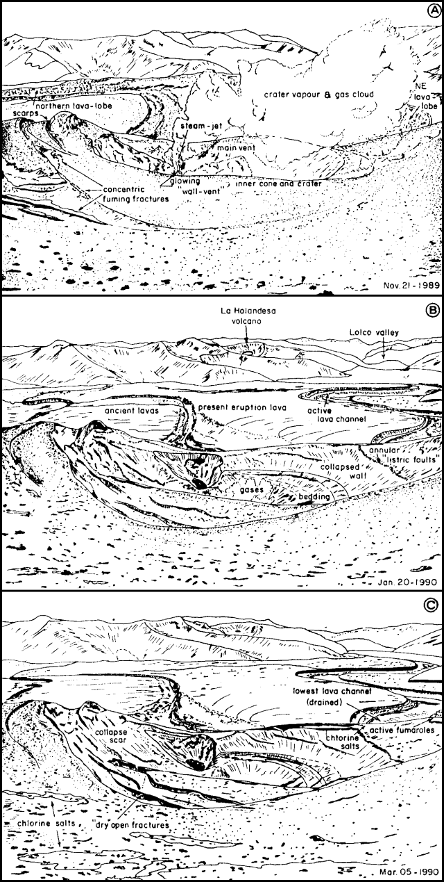 |
Figure 16. View N across the crater of Navidad scoria cone, Lonquimay volcano, from the highest (S) part of the rim. 21 November 1989 (top): Concentric fractures had formed on the W side of the innermost nested crater; intense water vapor fumaroles aligned with them, and a strong steam jet was emitted from a glowing vent on the inner wall. 20 January 1990 (middle): Vapor emission had ceased and collapse had occurred along the eastern inner wall, the southern fractures, and around the N wall-vent. A funnel-shaped crater about 120 m in diameter had clearly widened by collapse since November. 5 March 1990 (bottom): Only dry gases were emitted along the annular fractures, while no fumes were visible at the main crater vents. Fractures had widened on the S part of the cone, and collapse scars appeared on the E part. Sketched from photographs by J.A. Naranjo. |
"By March, the source vent was completely covered by talus from the unstable flank material above it. Discontinuous slumping of this debris left a funnel-shaped scar about 90 m high and 30 m deep, with walls that project upward through the crater's inner concentric fractures. The channel was enlarged by successive collapses that were up to 30 m deep and 25 m wide near the vent.
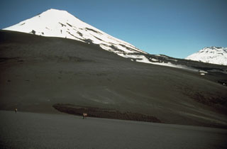
"The lava surface remained almost completely covered by a 1-3-m-thick mantle of debris transported on it. Former arched transverse debris ridges were disturbed and a gash of fresher lava was formed along the debris mantle's front axis. The top parts of most ridges showed higher temperatures (up to 390°C at 30 cm depth) than the almost cool gullies between them. After 20 January, the debris-covered lava advanced 120 m before it stopped flowing. This smooth surface texture conspicuously contrasted with the spiny, jagged surface presented by the blocky/aa lava immediately downstream.
"The fumaroles aligned with the central vent and the flow to the ENE showed decreased activity when compared to April 1989, although their temperatures remained at 190° and 250-300°C, 600 and 300 m from Navidad Cone respectively.
"On 17 March, a 948°C thermocouple measurement was obtained ~7 m below the lava surface, 1.5-2 km downstream from the source vent. The main lobe in the Lolco River valley had not advanced since 20 November 1989, although it showed a front thickness that had increased slightly, from 45-50 m in November to 55-60 m in March."
Geological Summary. Lonquimay is a small, flat-topped, symmetrical stratovolcano of late-Pleistocene to dominantly Holocene age immediately SE of Tolguaca volcano. A glacier fills its summit crater and flows down the S flank. It is dominantly andesitic, but basalt and dacite are also found. The prominent NE-SW Cordón Fissural Oriental fissure zone cuts across the entire volcano. A series of NE-flank vents and scoria cones were built along an E-W fissure, some of which have been the source of voluminous lava flows, including those during 1887-90 and 1988-90, that extended out to 10 km.
Information Contacts: J. Naranjo, SERNAGEOMIN, Santiago; H. Moreno, Univ de Chile.