Report on Long Valley (United States) — April 1990

Bulletin of the Global Volcanism Network, vol. 15, no. 4 (April 1990)
Managing Editor: Lindsay McClelland.
Long Valley (United States) S moat earthquake swarms of 6-7 May most intense since 1983-84
Please cite this report as:
Global Volcanism Program, 1990. Report on Long Valley (United States) (McClelland, L., ed.). Bulletin of the Global Volcanism Network, 15:4. Smithsonian Institution. https://doi.org/10.5479/si.GVP.BGVN199004-323822
Long Valley
United States
37.7°N, 118.87°W; summit elev. 3390 m
All times are local (unless otherwise noted)
Earthquake swarms continued in the S moat through early May, with bursts of activity (magnitude greater than or equal to 2.5) on 28 and 30 March, 18-20 April, and 6-7 May. The 6-7 May swarm was the most intense activity within the caldera since 1983-84. It began with an earthquake of about M 2.7 on 6 May at 2,238 and produced more than 300 of M >0.5 over the next 24 hours. The earthquakes included nearly 20 of magnitude greater than or equal to 2.5 and three of magnitude greater than or equal to 3, the largest of which was about M 3.5 at 0241. This swarm, as with most of the others that have occurred since the beginning of the year, was centered in the S moat, ~4 km E of the town of Mammoth Lakes (figure 12). Focal depths ranged from <3 km to as deep as 10 km, with most concentrated between 5 and 8 km (figure 13). Earthquakes in the S moat area as small as about M 2.5 are felt in Mammoth Lakes, and residents reported feeling some 15-20 events during a 5 1/2-hour period starting 6 May at 2238.
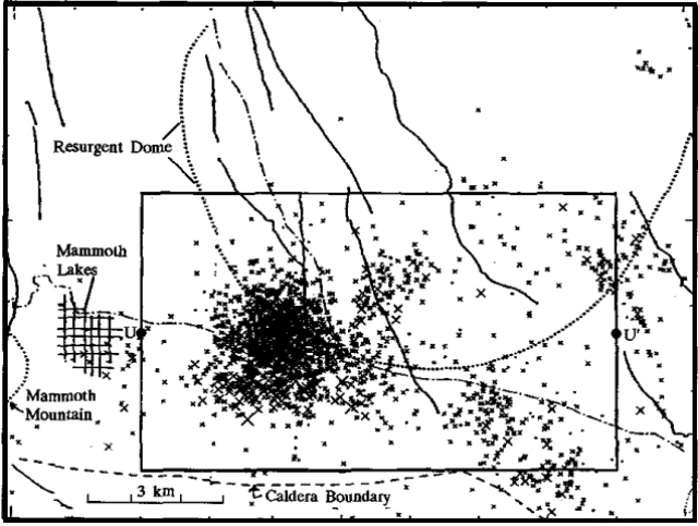 |
Figure 12. Epicenters of earthquakes in the Long Valley Caldera region, 1 January-10 May 1990. Courtesy of D. Hill. |
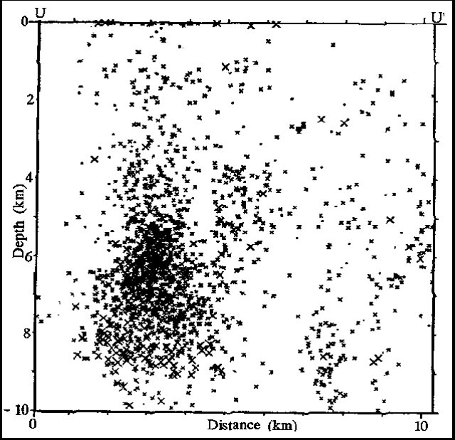 |
Figure 13. E-W cross-section from U to U' (figure 12), showing focal depths of Long Valley area earthquakes, 1 January-10 May 1990. Courtesy of David Hill. |
An approximately 5-fold increase in extensional strain across the S moat and resurgent dome began to be recorded by the caldera's 2-color geodimeter network in September 1989. The extension rate continued to average 4-5 ppm/year through early May, although recent measurements indicated that the rate may be slowing somewhat. Small strain changes, apparently associated with the 6-7 May swarm, were detected by borehole dilatometers at distances of 6 and 10 km. The changes were generally ~0.03-0.05 microstrain.
Geological Summary. The large 17 x 32 km Long Valley caldera east of the central Sierra Nevada Range formed as a result of the voluminous Bishop Tuff eruption about 760,000 years ago. Resurgent doming in the central part of the caldera occurred shortly afterwards, followed by rhyolitic eruptions from the caldera moat and the eruption of rhyodacite from outer ring fracture vents, ending about 50,000 years ago. During early resurgent doming the caldera was filled with a large lake that left strandlines on the caldera walls and the resurgent dome island; the lake eventually drained through the Owens River Gorge. The caldera remains thermally active, with many hot springs and fumaroles, and has had significant deformation, seismicity, and other unrest in recent years. The late-Pleistocene to Holocene Inyo Craters cut the NW topographic rim of the caldera, and along with Mammoth Mountain on the SW topographic rim, are west of the structural caldera and are chemically and tectonically distinct from the Long Valley magmatic system.
Information Contacts: D. Hill, USGS Menlo Park.