Report on Monowai (New Zealand) — August 1990
Bulletin of the Global Volcanism Network, vol. 15, no. 8 (August 1990)
Managing Editor: Lindsay McClelland.
Monowai (New Zealand) Extensive zone of sulfurous discolored water; bathymetric data show two plumes
Please cite this report as:
Global Volcanism Program, 1990. Report on Monowai (New Zealand) (McClelland, L., ed.). Bulletin of the Global Volcanism Network, 15:8. Smithsonian Institution. https://doi.org/10.5479/si.GVP.BGVN199008-242050
Monowai
New Zealand
25.887°S, 177.188°W; summit elev. -132 m
All times are local (unless otherwise noted)
A sharply defined zone of brown water extended W from the seamount's summit area during a visit by the research vessel HMNZS Tui on 13 August between 0800 and 1400. A strong sulfur smell was noted but no bubbles were visible. The surface temperature in discolored water 400 m from the plume's origin was 2.0 ± 0.5°C higher than that of the surrounding sea water. At 9 km from the summit, the plume of discolored water was ~3.7 km wide.
An attempt to contour the bathymetry of the top 500 m of the seamount (figure 1) was hampered by intermittent availability of GPS satellite fixes. Southern slopes appeared to have a regular cone shape, but the N slopes, where ship navigation was based on inputs from a gyrocompass and doppler log, appeared distorted to the NE. A minimum depth of 100 m was measured. Two vertical plumes extended to the surface.
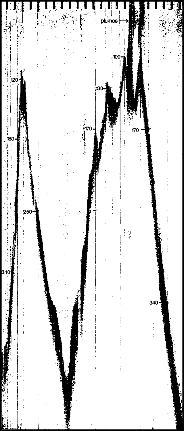 |
Figure 1. N-S profile across the summit of Monowai Seamount using a 45-kHz sounder. Vertical exaggeration 6:1. Depths are in meters. Two vertical plumes (not seen on the 12 kHz sounder) extend from the summit area to the surface. Courtesy of the Defence Scientific Establishment. |
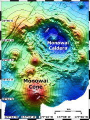
Geological Summary. Monowai, also known as Orion seamount, is a basaltic stratovolcano that rises from a depth of about 1,500 to within 100 m of the ocean surface about halfway between the Kermadec and Tonga island groups, at the southern end of the Tonga Ridge. Small cones occur on the N and W flanks, and an 8.5 x 11 km submarine caldera with a depth of more than 1,500 m lies to the NNE. Numerous eruptions have been identified using submarine acoustic signals since it was first recognized as a volcano in 1977. A shoal that had been reported in 1944 may have been a pumice raft or water disturbance due to degassing. Surface observations have included water discoloration, vigorous gas bubbling, and areas of upwelling water, sometimes accompanied by rumbling noises. It was named for one of the New Zealand Navy bathymetric survey ships that documented its morphology.
Information Contacts: Lt. Cdr. Owen Hanley, HMNZSTui, Auckland Naval Base, Auckland; L. Hall, Defence Scientific Establishment, Auckland Naval Base, Auckland.