Report on Kilauea (United States) — January 1991

Bulletin of the Global Volcanism Network, vol. 16, no. 1 (January 1991)
Managing Editor: Lindsay McClelland.
Kilauea (United States) Continued lava flow into sea; increased summit seismicity
Please cite this report as:
Global Volcanism Program, 1991. Report on Kilauea (United States) (McClelland, L., ed.). Bulletin of the Global Volcanism Network, 16:1. Smithsonian Institution. https://doi.org/10.5479/si.GVP.BGVN199101-332010
Kilauea
United States
19.421°N, 155.287°W; summit elev. 1222 m
All times are local (unless otherwise noted)
The majority of January lava . . . moved downslope through the W tube system, flowing into the ocean at three main entries along a 300-m front (figure 77). The W entry was very explosive. Lava entering the ocean . . . often interacted explosively with sea water, ejecting substantial quantities of spatter, limu, and Pele's hair onto the old sea cliff, and building a littoral cone 2-3 m high. The lava bench at the W entry did not grow > 10-20 m outward from the shore, but the two E entries built a bench that extended ~40 m . . . . Both E entries deposited a considerable amount of tephra onto the bench, and constructed large littoral cones. The new sea cliffs (built by recent, but not currently active flows) in the area were quite unstable, and pieces of the cliff frequently broke off. Portions of the bench < 10 m wide collapsed into the ocean. Underwater tubes have been observed offshore from all of the entries.
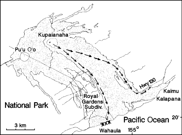 |
Figure 77. Lava produced by Kīlauea's East rift zone eruption, 1983-91. Arrows indicate lava flow in tubes, and crosses at the coast mark areas where lava was entering the ocean. Courtesy of HVO. |
Numerous lava breakouts occurred from the W tube system ~1 km behind the active ocean entries. None of this lava reached the ocean but the flows covered a large part of the flat area near the coast.
On the E side of the flow field, only small lava breakouts were observed in the Kalapana area during January. Most of these occurred at the end of the coast highway, covering more of the road. The lobe that destroyed a house on 10 January then stagnated, and no additional houses have been threatened. In late January, a large flow broke out of the E tube system at higher elevation, burning vegetation on the slopes above Kalapana. It reached 200 m (700 ft) elevation by 28 January, and ~90 m (300 ft) elevation by 6 February.
The summit of Pu`u `O`o cone was 236 m above the pre-eruption surface during a January 1991 survey. Since June 1986, just before activity shifted 3 km downrift to Kupaianaha, erosion and collapse had reduced the summit elevation by 21 m and widened the crater from ~15 m to some 280 m in diameter. A lava pond was active in Pu`u `O`o through January. About half of the crater floor was covered by debris from recent crater wall collapses, while the remainder was occupied by the pond, lava overflows from the pond, and a small apparent skylight in the overflow area.
Continuous volcanic tremor persisted along the East rift zone through January, fluctuating in amplitude near Kupaianaha and Pu`u `O`o, but remaining relatively steady at the station nearest the ocean entries on the W side of the tube system. Summit seismicity was dominated by very numerous shallow harmonic tremor events at depths to 5 km. Their number increased at the end of December, and they became larger (and thus easier to identify) through January. Event counts averaged just under 600/day during 1-21 January, but a rather abrupt increase occurred 19-21 January and the daily average more than quadrupled to >2,700/day since 22 January (figure 78).
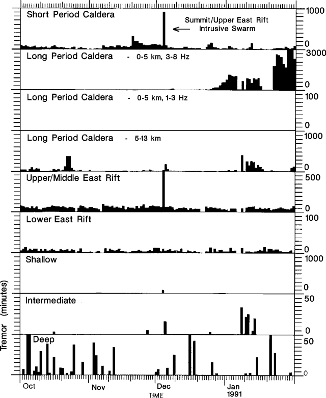 |
Figure 78. Number of earthquakes/day at Kīlauea, 1 October 1990-31 January 1991, subdivided into event types. Tremor rates are shown in number of minutes/day. Note the 4-5 December intrusion earthquake swarm and the striking increase in long-period caldera events in December and January. Courtesy of P. Okubo. |
Geological Summary. Kilauea overlaps the E flank of the massive Mauna Loa shield volcano in the island of Hawaii. Eruptions are prominent in Polynesian legends; written documentation since 1820 records frequent summit and flank lava flow eruptions interspersed with periods of long-term lava lake activity at Halemaumau crater in the summit caldera until 1924. The 3 x 5 km caldera was formed in several stages about 1,500 years ago and during the 18th century; eruptions have also originated from the lengthy East and Southwest rift zones, which extend to the ocean in both directions. About 90% of the surface of the basaltic shield volcano is formed of lava flows less than about 1,100 years old; 70% of the surface is younger than 600 years. The long-term eruption from the East rift zone between 1983 and 2018 produced lava flows covering more than 100 km2, destroyed hundreds of houses, and added new coastline.
Information Contacts: T. Moulds and P. Okubo, HVO.