Report on Planchon-Peteroa (Chile) — January 1991
Bulletin of the Global Volcanism Network, vol. 16, no. 1 (January 1991)
Managing Editor: Lindsay McClelland.
Planchon-Peteroa (Chile) Ash eruption to 1 km; drinking water contaminated; fish killed
Please cite this report as:
Global Volcanism Program, 1991. Report on Planchon-Peteroa (Chile) (McClelland, L., ed.). Bulletin of the Global Volcanism Network, 16:1. Smithsonian Institution. https://doi.org/10.5479/si.GVP.BGVN199101-357040
Planchon-Peteroa
Chile
35.223°S, 70.568°W; summit elev. 3977 m
All times are local (unless otherwise noted)
At 0140 on 9 February, a tephra eruption began at Planchón-Peteroa, a large basaltic to dacitic volcanic complex on the Chile-Argentina border roughly 200 km S of Santiago (figure 1). The eruption was continuing at press time (15 February), with no notable changes in eruptive style. No lava emission has been observed; the most recent lava flow, a mafic andesite, was erupted in February 1937.
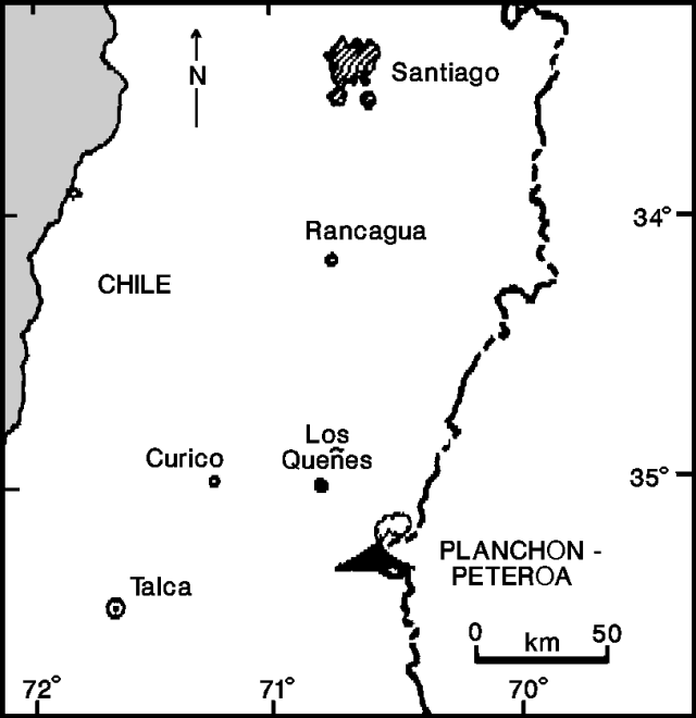 |
Figure 1. Map showing the location of Planchón-Peteroa. Courtesy of M. Gardeweg. |
Police in Carrizales (25 km NW) reported weak felt seismicity, followed by an explosion and the ejection of a brown column of gas and ash. No further seismicity was felt but there were no seismographs in the area. The eruption column averaged 400-700 m high and seldom exceeded 1,000 m. It was mainly formed by abundant pulses of vapor, with smaller, dense pulses of ash occurring every 10-15 minutes. The latter were audible 600-700 m from the crater. A weak sulfur odor was reported. Oscar González-Ferrán described the activity during his 11 February overflight as a low-level phreatomagmatic eruption.
The plume traveled ENE into Argentina, at an altitude of roughly 5,000-6,000 m. NOAA weather satellite images on 11 February showed the plume extending 80 km E and ~ 30 km N-S. A change in wind direction on 13 February caused ashfall as far as 70 km W of the crater, alarming area residents.
Large numbers of fish were killed in the Claro and Teno rivers, and the water supply for Los Queñes (population ~1,200), 35 km NW of the volcano, was contaminated. Contamination of the Río Claro may have occurred during the initial phase of the eruption, as water ejected from the crater lake, mixed with ice and tephra, entered the river (figure 2). Analyses of water taken from the Teno and Claro on 9 February showed notable increases in Fe and Mn contents, increases in turbidity, and a lowering of pH (table 1). Decreased contamination levels were noted 2 days after the start of the eruption. Potable water continued to be shipped to Los Queñes by special trucks. Ash now covers the small ice fields surrounding the active crater, and mixing of ash and melt from these fields may have caused additional contamination. Possible increases in eruptive activity and increased snowmelt caused by the ash cover present potential lahar hazards.
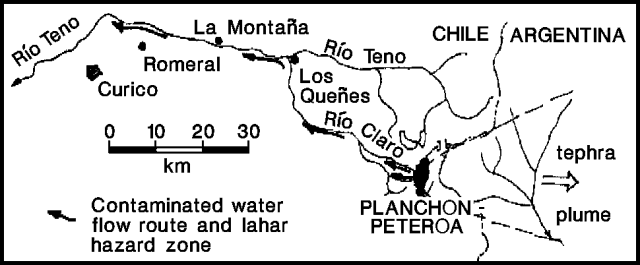 |
Figure 2. Sketch showing Planchón-Peteroa drainage, route of water contamination, and plume orientation, 11 February 1991. Courtesy of O. González-Ferrán. |
Table 1. Analyses of Los Queñes water from the Claro and Teno rivers by Empresa de Servicios Sanitarios del Maule S.A., NW slope of Planchón-Peteroa, February 1991. Standard column is the Chilean standard set by the Instituto Nacional de Normalizacion. Courtesy of M. Gardeweg.
| Date | Standard | Baseline | 09 Feb 1991 | 11 Feb 1991 | 11 Feb 1991 |
| River | -- | Teno | Claro | Claro | Teno |
| pH (30°C) | 5.9 | 7.7 | 3.7 | 5.6 | 6.95 |
| Fe (total mg/l) | 0.3 | 0.2 | 219.8 | 27.9 | 0.14 |
| Mn (mg/l) | 0.1 | less than 0.1 | 0.6 | 0.59 | 0.05 |
| Chlorides (mg/l) | 250 | 20.6 | 274.4 | 61.7 | 46.6 |
| CaCO3 (mg/l) | -- | 59.4 | 335 | -- | 109 |
| Conductivity | 395 | 14.2 | 1500 | 580 | 400 |
| Turbidity (NTU) | 5 | 1.7 | 3150 | 800 | 8.2 |
| Comments | -- | odorless | sulfur odor, ash | ash | odorless |
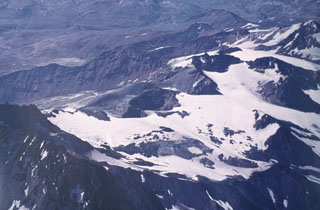
The eruption crater (200 m in diameter, within a 500-m-diameter crater), is in a depression between the cones of Planchón and Peteroa (figures 3 and 4). The larger crater has a rim elevation of 3,490 m and was the site of explosive activity during 1959, 1960, and 1967. On 25 March 1985, the inner crater was partially filled by a sulfurous lake (150 m in diameter), but no other activity was observed. A new fumarole field (100 m2 in area) was noted 16 February 1987 near the source of the 1937 lava (Moreno and Tormey, 1987, and 12:3). Lavas as old as 0.55 million years are found in the complex, which also includes products from Azufre volcano . . . to the SE (Tormey and others, 1989). The structure of the edifice is complicated by at least two syn-volcanic glaciations and a large debris avalanche (the "Teno Lahar") that removed a sector of Planchón.
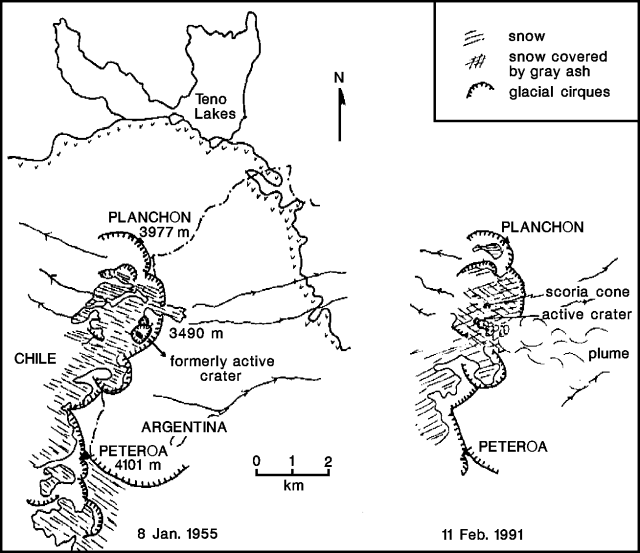 |
Figure 3. Sketch maps of the summit of Planchón-Peteroa based on 8 January 1955 (left) and 11 February 1991 (right) aerial photos. Courtesy of M. Gardeweg. |
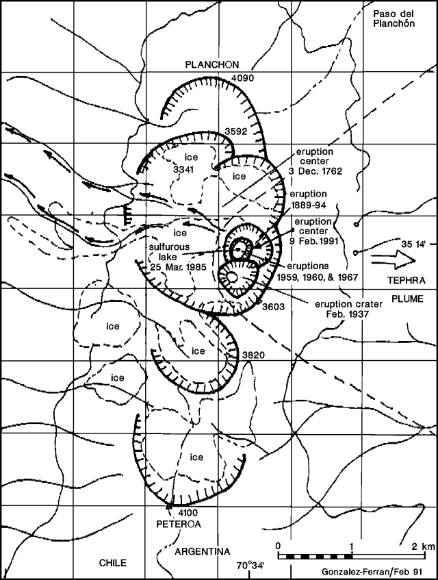 |
Figure 4. Sketch map showing the summit region and craters of Planchón-Peteroa, February 1991. Courtesy of O. González-Ferrán. |
References. Moreno R., H. and Tormey, D., 1987, New fumarolic activity at Peteroa volcano: EOS, v. 68, p. 500.
Tormey, D., Frey, F., and López-Escobar, L., 1989, Geologic history of the active Azufre - Planchón-Peteroa Volcanic Center (35°15'S, southern Andes) with implications for the development of compositional gaps: Asoc. Geol. Arg. Rev. XLIV (1-4), p. 420-430.
Geological Summary. Planchón-Peteroa is an elongated complex volcano along the Chile-Argentina border with several overlapping calderas. Activity began in the Pleistocene with construction of the basaltic andesite to dacitic Volcán Azufre, followed by formation of the basaltic and basaltic andesite Volcán Planchón, 6 km N. About 11,500 years ago much of Azufre and part of Planchón collapsed, forming the massive Río Teno debris avalanche, which traveled 95 km to reach Chile's Central Valley. Subsequently, Volcán Planchón II was formed. The youngest volcano, andesitic and basaltic andesite Volcán Peteroa, consists of scattered vents between Azufre and Planchón, and and contains a small steaming crater lake. Reported eruptions from the complex have been dominantly explosive, although lava flows were emplaced in 1837 and 1937.
Information Contacts: Moyra Gardeweg, SERNAGEOMIN, Santiago; Oscar González-Ferrán, Univ de Chile; SAB.