Report on Hekla (Iceland) — January 1991
Bulletin of the Global Volcanism Network, vol. 16, no. 1 (January 1991)
Managing Editor: Lindsay McClelland.
Hekla (Iceland) Tephra cloud to 10 km above summit; ashfalls to N coast; fluid lava flows from fissure vent
Please cite this report as:
Global Volcanism Program, 1991. Report on Hekla (Iceland) (McClelland, L., ed.). Bulletin of the Global Volcanism Network, 16:1. Smithsonian Institution. https://doi.org/10.5479/si.GVP.BGVN199101-372070
Hekla
Iceland
63.983°N, 19.666°W; summit elev. 1490 m
All times are local (unless otherwise noted)
[A preliminary report of Hekla's early 1991 eruption appeared in 15:12. Additional information from Agust Gudmunsson, printed in 16:1, has been added in brackets, replacing some of the original material from 15:12.]
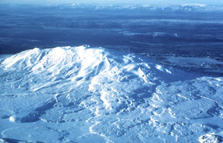
On 17 January, after 10 years of repose, an eruption ejected tephra columns and fed numerous fluid lava flows from fissure vents. Local farmers noticed strong sulfurous smells around 1200-1300, 4-5 hours before the eruption began. Instruments, however, gave less than [30] minutes warning of the eruption. [The first earthquake associated with the eruption occurred at 1632. From 1642, the earthquakes increased in number and the largest attained M 3. Seven borehole strainmeters are located 14-45 km from Hekla, and a conspicuous strain pulse was recorded at 1636, just after the first earthquake. Volcanic tremor started at about 1700. No eruption column was detected by Icelandic Meteorological Office radar at 1700, but it had attained 11.5 km height at 1710. The eruption column was observed from nearby farms at 1705 and 1707.]
Images from the Meteosat geostationary satellite showed a plume extending NNE (azimuth 010°), over an uninhabited area, and by 2000 it was approaching the coast (more than 200 km from the volcano), where light ashfall was reported. Feeding of the eruption cloud appeared to have stopped by 2000, and the plume was clearly detached from the volcano by 2100. At 2300, Meteosat images showed a second eruption cloud, which was again carried NNE and reached 300 km in length before dissipating by 0300. Weather clouds then prevented additional satellite observations.
[During the early hours of the eruption, several fissures were active, including the southern part of the main Hekla fissure.] Numerous lava flows advanced W, E, and S, extending 4-5 km by midnight. Four flank vents were visible and glow could be seen from the summit area, obscured by clouds. Lava viscosity was relatively low, producing comparatively thin, fast-moving flows reminiscent of the 1980 eruption. [Tremor began to decrease at about 1800 and by 0400 the next morning was already down to a relatively low level. Since then it has been slowly decreasing, with occasional short-term increases.
On the second day of the eruption, activity was already more or less restricted to a single fissure on the lower southern flank, trending SE from the top of the volcano. One crater on this fissure was still active as of 8 February. Slight activity could be seen in another fissure on the S side of the volcano until 20 January, but with very little lava flow and no fountains.
The volume of freshly fallen tephra is estimated at roughly 0.02 km3. This is about 1/3 of the estimated volume of tephra generated during Hekla's eruptions in 1970 and 1980. The total area covered by newly erupted lava is 22-23 km2, and the estimated volume of this lava is 0.13 km3 [see also 16:3]. For comparison, the lava from the 1980 eruption covers 24 km2 and its volume is estimated at 0.15 km3. Similarly, the 1970 lava covers 18.5 km2 and has an estimated volume of 0.2 km3. The composition of the 1991 lava is very similar to that of the 1970 and 1980 lavas.]
Hekla, one of the most active volcanoes in Iceland, is near the intersection of the Eastern Volcanic Zone and the transform zone of S Iceland. Although near a zone of spreading, it is not a typical rift volcano. Its products are intermediate to acid in composition. The last two repose periods (1970-80 and 1981-91) are the shortest in Hekla's known history, since 1104. Hekla's previous eruption began on 17 August 1980 and produced about 120 x 106 m3 of lava and 60 x 106 m3 of tephra before activity stopped on 20 August. The eruption resumed on 9 April 1981, extruding another 30 x 106 m3 of lava in the succeeding week; [these two episodes are usually regarded as a single eruption] (Grönvold and others, 1983).
Reference. Grönvold, K., Larsen, G., Einarsson, P., Thorarinsson, S., and Saemundsson, K., 1983, The Hekla eruption 1980-1981: BV, v. 46, p. 349-363.
Geological Summary. One of Iceland's most prominent and active volcanoes, Hekla lies near the southern end of the eastern rift zone. Hekla occupies a rift-transform junction, and has produced basaltic andesites, in contrast to the tholeiitic basalts typical of Icelandic rift zone volcanoes. Vatnafjöll, a 40-km-long, 9-km-wide group of basaltic fissures and crater rows immediately SE of Hekla forms a part of the Hekla-Vatnafjöll volcanic system. A 5.5-km-long fissure, Heklugjá, cuts across the 1491-m-high Hekla volcano and is often active along its full length during major eruptions. Repeated eruptions along this rift, which is oblique to most rifting structures in the eastern volcanic zone, are responsible for Hekla's elongated ENE-WSW profile. Frequent large silicic explosive eruptions during historical time have deposited tephra throughout Iceland, providing valuable time markers used to date eruptions from other Icelandic volcanoes. Hekla tephras are generally rich in fluorine and are consequently very hazardous to grazing animals. Extensive lava flows from historical eruptions, which date back to 1104 CE, cover much of the volcano's flanks.
Information Contacts: P. Einarsson and S. Björnsson, Univ of Iceland; [A. Gudmunsson and]E. Tryggvason, NVI; O. Karst and J. Paquette, NOAA.