Report on Colima (Mexico) — February 1991

Bulletin of the Global Volcanism Network, vol. 16, no. 2 (February 1991)
Managing Editor: Lindsay McClelland.
Colima (Mexico) Lava extrusion onto summit dome after increased seismicity and fumarolic activity; fish kill in nearby lakes
Please cite this report as:
Global Volcanism Program, 1991. Report on Colima (Mexico) (McClelland, L., ed.). Bulletin of the Global Volcanism Network, 16:2. Smithsonian Institution. https://doi.org/10.5479/si.GVP.BGVN199102-341040
Colima
Mexico
19.514°N, 103.62°W; summit elev. 3850 m
All times are local (unless otherwise noted)
New lava was extruded onto the summit dome after several weeks of increased seismicity, fumarolic activity, and dome fracturing.
Increased seismicity, mid-late February. Seismicity increased briefly on 14 February and strong fumarolic activity was observed on 16 February. [RESCO instruments recorded] a new seismic swarm that began on 23 February at about 1800, producing about 150 recognizable events in the first 24 hours and an additional 180 events in the following 24 hours (figures 11 and 12). A- and B-type earthquakes were again detected, and frequent small- to medium-sized Merapi-like (but non-incandescent) avalanches moved down the volcano's flanks from the crumbling edges of the summit lava dome. A white to sometimes light gray plume rose from the dome to a maximum height of roughly 1,000 m. No ashfalls have been reported. Records from a portable seismograph on the caldera floor showed little correlation between earthquakes and the avalanches, which produced a signal of distinctly higher frequency. However, fairly large B-type events sometimes seemed to trigger avalanches. On 26 February, 21 avalanches were observed in 6 hours. A period of relative seismic quiescence between 1530 and 2000 on 25 February was followed by renewed seismicity that continued at a rate of about 130 events/day. Some of the earthquakes have been located at 1-3 km depth ~6 km NNW of the volcano. Seismicity began to decrease after 27 February, but the number of avalanches increased, reaching a maximum on 2 March.
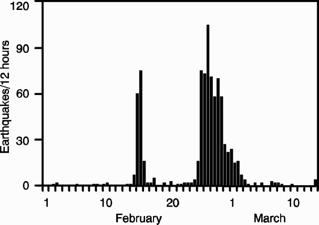 |
Figure 11. Number of seismic events recorded in 12-hour periods at RESCO reference station EZV6, about 8 km SW of Colima's summit, 1 February-13 March, 1991. |
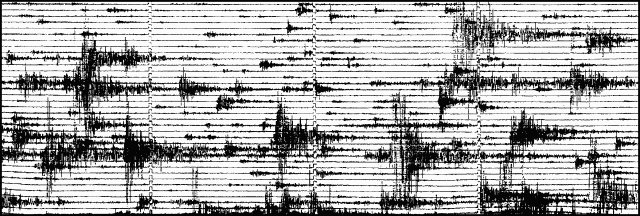 |
Figure 12. Section of a seismogram recorded on 25 February at RESCO station EZV7, on Colima's E flank. |
Dome deformation and thermal activity, late February. During a 26 February ascent by Mitchell Ventura F. and Charles Connor, heavy degassing was occurring from the summit dome, concentrated on its SE and W sides. The hottest fumaroles (500-600°C) had been on the dome's W side during the past year (15:02). Since previous fieldwork on 16 December, new radial fractures had developed, 10->100 m long, 1 cm-1.5 m wide, and sometimes open to 5 m depth or more. Low-temperature (<200°C) fumaroles were found along most of the fractures. Fracture density was greatest on the dome's N to NW flanks, above a recent avalanche scar. Many of those fractures were 1-1.5 m wide and had vertical throws of 1-2 m (always down on the downslope side). Rockfalls were continuous on the dome's W to NW flanks, including blocks to 10 m3. Light lithic tephra falls occurred on the dome at about 1320 and 1345, within 150 m of the most active degassing in its W-central part.
Lava extrusion, early March. New lava was first observed on the dome 1 March. When [Ventura and Connor returned to] the summit the next day, the new lobe, on the W-central part of the dome, was ~20 m across and 6.5 m high. New lava was visible only on its top 1.5 m; the lower 5 m consisted of a steep rubble slope of old dome material. The most easily observed W side of the new lobe had an aa-like texture and was not highly fractured. Plagioclase phenocrysts were visible in the dark, apparently andesitic, lava. Although several rockfalls occurred from the lobe's lower slopes during 15 minutes of observation, no incandescence or lava movement was evident. Vigorous degassing occurred from a surrounding moat about 5 m wide, and the area was strongly fractured, mostly radial to the new extrusion. However, overall degassing had declined substantially. At one site ~75 m NW of the new lobe, along a prominent radial fracture, the strong fumarolic activity of 26 February had completely stopped by 2 March. Nearly all of the summit dome's prominent spines had been removed by heavy avalanching since 26 February.
[Ana Lillian Martín del Pozzo and colleagues reported that] by 3 March, the new lobe was slightly taller. When next observed 2 days later, a narrow tongue of lava had emerged from a breach in the lobe's E base and had been channeled into the adjacent moat. The (southward-sloping) lobe was estimated at 15 m high and 50 m across on 6 March. After that date, degassing and seismicity decreased sharply.
By mid-March, [CICBAS reported that] the new lobe was of sufficient size to be visible from Colima city (~30 km SSW of the volcano). Fumarolic activity increased again about 10 March, but seismicity remained at a low level. Geodetic data (J. Murray) showed little deformation of the somma-type caldera surrounding the N side of the volcano.
Seismic net. On 5 March, RESCO installed a new telemetering seismic station on the volcano's NNW flank (at El Soma), bringing the total number of telemetering stations to five on the volcano and two others nearby (at Alcomun and Cerro Grande). The digital acquisition system was re-established on 9 March.
Changes to nearby lakes. An abrupt 30-cm drop in the level of a group of small lakes 10.5 km SW of the summit (figure 13) was reported on 7 March. The level change in the largest lake (~200 m in diameter) was followed by the death of most fish within a few hours. Water samples collected on 10 March showed [fairly] high concentrations of CO32- and HCO3 and very low (below detection limits) concentration of As. The dead and dying fish showed no evidence of disease and no chemical products or insecticides are used in the area. Geologists noted that "Although it is difficult to give a definite explanation of the origin of these phenomena, the events may be interpreted in terms of the sudden dissolution of important quantities of CO2 in the lake water. This may be caused by fracturing associated with the the recent increase in shallow seismic activity at Colima, allowing magmatic gases to reach the aquifer system. At the measured pH of the water (8.90), the dissolved CO2 is present as carbonate and bicarbonate." [But this drop in lake level was later attributed to normal withdrawal of irrigation water; see 16:04.]
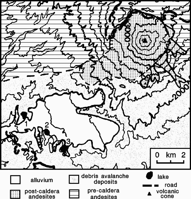 |
Figure 13. Sketch map of Colima and the area to the S and W. Contour interval, 200 m. A group of lakes SW of the volcano was affected by fish kills and declines in water level: 1 - La María; 2 - El Jabalí; 3 - La Escondida. After Luhr, J. and Prestegaard, K., 1988, Caldera formation at Volcán Colima, México, by a large Holocene volcanic debris avalanche: JVGR, v. 35, p. 335-348. |
Geological Summary. The Colima complex is the most prominent volcanic center of the western Mexican Volcanic Belt. It consists of two southward-younging volcanoes, Nevado de Colima (the high point of the complex) on the north and the historically active Volcán de Colima at the south. A group of late-Pleistocene cinder cones is located on the floor of the Colima graben west and east of the complex. Volcán de Colima (also known as Volcán Fuego) is a youthful stratovolcano constructed within a 5-km-wide scarp, breached to the south, that has been the source of large debris avalanches. Major slope failures have occurred repeatedly from both the Nevado and Colima cones, producing thick debris-avalanche deposits on three sides of the complex. Frequent recorded eruptions date back to the 16th century. Occasional major explosive eruptions have destroyed the summit (most recently in 1913) and left a deep, steep-sided crater that was slowly refilled and then overtopped by lava dome growth.
Information Contacts: Gilberto Ornelas-Arciniega, Ariel Ramírez-Vázquez, Francisco Núñez-Cornú, Hector Tamez, Guillermo Castellanos, and G.A. Reyes-Dávila, CICBAS, Universidad de Colima; S. de la Cruz-Reyna, I. Yokoyama, A. Nava, Z. Jiménez, and M.A. Armienta Hernández, UNAM; Julián Flores, Instituto de Geografía y Estadística, Univ de Guadalajara; C.B. Connor, FIU, Miami; Ana Lillian Martín del Pozzo, A. Aguayo, and J. Panohaya, Instituto de Geofísica, UNAM; D. Barrera, Centro de Ciencias de la Tierra, Univ de Guadalajara; Juan N. Cumplido, Guadalajara, México, G. González, Univ Autónoma de Puebla.