Report on Long Valley (United States) — March 1991

Bulletin of the Global Volcanism Network, vol. 16, no. 3 (March 1991)
Managing Editor: Lindsay McClelland.
Long Valley (United States) Earthquake swarm in S moat is most intense inside the caldera since 1983-4
Please cite this report as:
Global Volcanism Program, 1991. Report on Long Valley (United States) (McClelland, L., ed.). Bulletin of the Global Volcanism Network, 16:3. Smithsonian Institution. https://doi.org/10.5479/si.GVP.BGVN199103-323822
Long Valley
United States
37.7°N, 118.87°W; summit elev. 3390 m
All times are local (unless otherwise noted)
All times are UTC. The following is a report from David Hill.
"Strong earthquake swarm activity resumed ... during the last week in March, after nearly nine months of sporadic seismic activity at low-to-moderate levels. The swarm began at 2212 on 23 March with a M 3 earthquake and several M >2 events. The rate increased significantly beginning about 0500 on 24 March with the occurrence of 5 additional M >3 events accompanied by more than 40 M >1 events/hour over the next five hours. Activity gradually slowed through the remaining hours of the 24th and the first half of the 25th with occasional M 3 events, only to surge to an even higher level beginning about 1630 on the 25th and continuing through the 26th. This last phase of the swarm included more than 15 M >3 events (the largest of which approached M 3.6) together with hundreds of smaller events. Altogether, the swarm included 22-25 M >3 earthquakes and >1,000 smaller events, with a cumulative seismic moment comparable to that of a single M 4 earthquake.
"The swarm was located in the S moat of the caldera ~4 km E of Mammoth Lakes (figure 14). Preliminary hypocentral locations indicate that most of the earthquakes were confined within a relatively tight cluster roughly 2 km in diameter with most of the focal depths between 4 and 6 km. This is essentially the same volume of crust that has produced numerous swarms since the early 1980 onset of unrest in the caldera; it contained the epicenter of one of the four M 6 earthquakes that occurred during the May 1980 sequence as well as the two M 5.3 earthquakes during the January 1983 S moat swarm. This is the most intense swarm within the caldera since the 1983-84 activity in terms of the total number of M >3 earthquakes in less than a week.
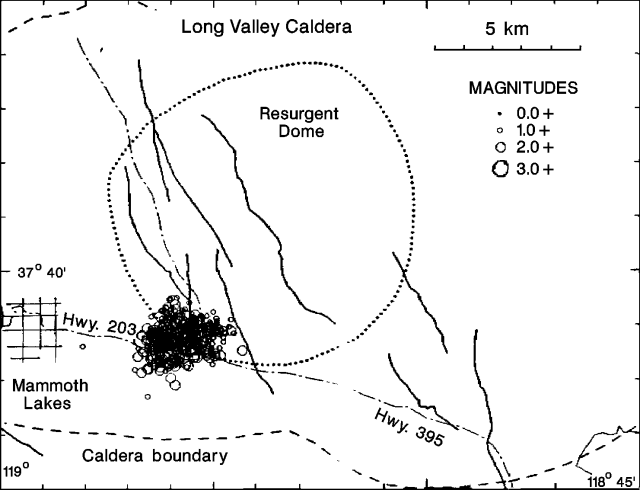 |
Figure 14. Epicenters of best-located swarm earthquakes at Long Valley, 23-26 March, 1991. Events were recorded by at least 12 stations; horizontal uncertainty 0.5 km, vertical uncertainty 1.0 km; travel time residual 0.15 s. Courtesy of David Hill. |
"We saw little evidence of deformation associated with this swarm. The borehole dilatometers showed no significant changes during the swarm, and measurements of the two-color geodimeter lines before and after the swarm showed only minor extension (a few mm at most). Over the longer term, however, the two-color data indicate that the resurgent dome continues to inflate at a rate of ~2 microstrain/year. This is roughly twice the rate that persisted through the last half of the 1980's. The current rate represents the gradually slowing tail of a renewed episode of inflation that began in early Oct 1989 with an abrupt acceleration in rate to 9 microstrain/year."
Geological Summary. The large 17 x 32 km Long Valley caldera east of the central Sierra Nevada Range formed as a result of the voluminous Bishop Tuff eruption about 760,000 years ago. Resurgent doming in the central part of the caldera occurred shortly afterwards, followed by rhyolitic eruptions from the caldera moat and the eruption of rhyodacite from outer ring fracture vents, ending about 50,000 years ago. During early resurgent doming the caldera was filled with a large lake that left strandlines on the caldera walls and the resurgent dome island; the lake eventually drained through the Owens River Gorge. The caldera remains thermally active, with many hot springs and fumaroles, and has had significant deformation, seismicity, and other unrest in recent years. The late-Pleistocene to Holocene Inyo Craters cut the NW topographic rim of the caldera, and along with Mammoth Mountain on the SW topographic rim, are west of the structural caldera and are chemically and tectonically distinct from the Long Valley magmatic system.
Information Contacts: D. Hill, USGS Menlo Park.