Report on Pinatubo (Philippines) — April 1991

Bulletin of the Global Volcanism Network, vol. 16, no. 4 (April 1991)
Managing Editor: Lindsay McClelland.
Pinatubo (Philippines) Phreatic explosion devastates 1 km2 forested area; seismicity and gas emission continue; 2,000 evacuated
Please cite this report as:
Global Volcanism Program, 1991. Report on Pinatubo (Philippines) (McClelland, L., ed.). Bulletin of the Global Volcanism Network, 16:4. Smithsonian Institution. https://doi.org/10.5479/si.GVP.BGVN199104-273083
Pinatubo
Philippines
15.13°N, 120.35°E; summit elev. 1486 m
All times are local (unless otherwise noted)
The following includes a more detailed account of events reported in 16:3.
On 2 April, an explosion at the E end of Pinatubo's geothermal area (about 1.5 km NW of the summit and 2/3 of the way down the flank) ejected clouds of steam and minor quantities of ash to 500-800 m height. Ash fell 2 km away, primarily to the NW and SW, and covered an area of about 10,000 m2, including part of one village, from which about 2,000 people were evacuated. No injuries or deaths were reported. The ash was composed of sub-angular material, none of which was freshly vesiculated, with a mineralogy of plagioclase, hornblende, small amounts of biotite, and possible quartz. About 1 km2 of forested land was devastated by the explosion, extending about 500 m from the explosion site, and leaves and vegetation were stripped over several square kilometers. Downed trees were preferentially oriented N.
Following the explosion, an ENE-WSW-trending line (roughly 1 km long at 1,100-1,350 m elevation - summit elevation is 1,745 m) of new fumaroles with six main vents had developed. The most intense activity was located at the W end of the line, while the blast site, at the E end of the line, had ceased activity (figure 2). Vent emissions, voluminous and at extremely high pressure, consisted mainly of steam, with an H2S odor and an associated gray haze. Plumes (~200-500 m high in mid- to late-April, 100-300 m high in early May) were carried W by the prevailing wind, onto a zone of dead and dying vegetation. Respiratory and eye irritation forced about 5,000 W-flank residents to leave the area. Increased discharge from springs near the fumaroles caused rapid downward erosion in stream beds, and muddy water was reported in the N drainages.
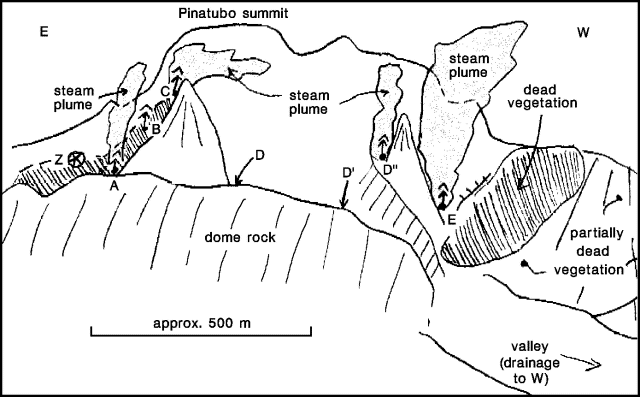 |
Figure 2. Sketch looking SSE at Pinatubo on 27 April 1991, from about 1 km distance (at geothermal well site PN-3, drilled in 1989 by PNOC). Fumaroles are labeled A-E, and the explosion site is labeled Z. Courtesy of David Sussman. |
A seismometer installed on 5 April recorded 223 high-frequency volcano-tectonic earthquakes over a 24-hour period (figure 3). Seismicity rapidly decreased, with 50-90 events recorded/day 8 April-10 May (the seismometer did not function 6-8 April). Earthquake location became possible on 6 May with the completion of a seismic network at the volcano. During the first few days of operation, earthquakes were centered [~4-8 km NW] of the summit at 3-6 km depth, and had magnitudes of 0.1-1.5 (averaging about M 1.0). The events all had the same first motions, suggesting that they had the same focal mechanisms. Seismicity increased on 10 May (167 recorded earthquakes/day) and remained high as of 12 May (120-150/day). No long-period events have been recorded.
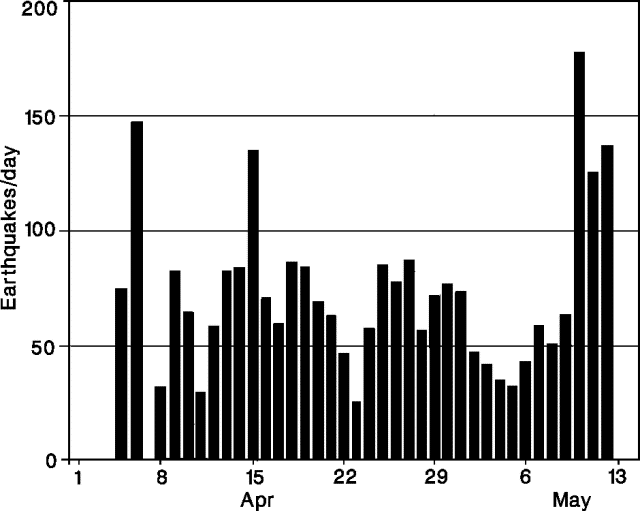 |
Figure 3. Daily number of recorded earthquakes at Pinatubo, 5 April-12 May 1991. Courtesy of PHIVOLCS. |
Deformation measurements on the NW slope have not shown evidence of inflation.
The center of the Pinatubo geothermal area, previously the site of several low-discharge acid-sulfate springs and three steaming sulfur-depositing fumaroles (>90°C), was located within a crater-like structure largely related to collapse. Geologists believe that some of the breccias in the structure's wall are probably of hydrothermally explosive origin. "Numerous alleged eruptive activities have been reported in the area."
Geological Summary. Prior to 1991 Pinatubo volcano was a relatively unknown, heavily forested lava dome complex located 100 km NW of Manila with no records of historical eruptions. The 1991 eruption, one of the world's largest of the 20th century, ejected massive amounts of tephra and produced voluminous pyroclastic flows, forming a small, 2.5-km-wide summit caldera whose floor is now covered by a lake. Caldera formation lowered the height of the summit by more than 300 m. Although the eruption caused hundreds of fatalities and major damage with severe social and economic impact, successful monitoring efforts greatly reduced the number of fatalities. Widespread lahars that redistributed products of the 1991 eruption have continued to cause severe disruption. Previous major eruptive periods, interrupted by lengthy quiescent periods, have produced pyroclastic flows and lahars that were even more extensive than in 1991.
Information Contacts: R. Punongbayan, PHIVOLCS; Chris Newhall, USGS Reston; John Ewert, CVO; David Sussman and Areberto Arevalo, Philippine Geothermal Inc., Manila.