Report on Whakaari/White Island (New Zealand) — May 1991

Bulletin of the Global Volcanism Network, vol. 16, no. 5 (May 1991)
Managing Editor: Lindsay McClelland.
Whakaari/White Island (New Zealand) Ash emission from new vent; continued deformation
Please cite this report as:
Global Volcanism Program, 1991. Report on Whakaari/White Island (New Zealand) (McClelland, L., ed.). Bulletin of the Global Volcanism Network, 16:5. Smithsonian Institution. https://doi.org/10.5479/si.GVP.BGVN199105-241040
Whakaari/White Island
New Zealand
37.52°S, 177.18°E; summit elev. 294 m
All times are local (unless otherwise noted)
Ash-laden steam emission was reported starting 23 April and continued as of 27 May. An 18 May visit revealed that activity was centered at a newly formed vent in the NE part of 1978/91 Crater (figure 13), near a zone of hot ground first observed on 21 April. Considerable ash accumulation had already occurred in the surrounding area.
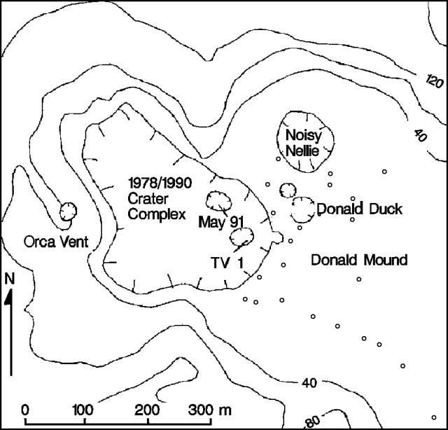 |
Figure 13. Sketch map of White Island on 27 May 1991, showing the new May 91 Vent. Dots mark deformation bench marks. Contour interval, 40 m. Courtesy of DSIR. |
During 27May fieldwork, the new vent (named May 91) almost continuously (>=1 pulse/second) emitted a column of gas and minor ash 500-600 m high, depositing dry material, plus some moist sub-millimeter aggregates. The vent, against the NE crater wall, was surrounded by a tuff cone 35-40 m in diameter and 8-10 m high, but no ballistic ejecta were visible. Orca and TV1 Craters quietly emitted weak steam.
Up to 95 mm of ash had accumulated since 21 May at a site 125 m SSE of May 91 vent, of which at least 25 mm was from the new vent. Tephra had infilled the small lake in the vicinity of R.F. Vent (near the SE wall of 1978/90 Crater), and small mudflows traveled across the crater floor. Ash contained a high proportion of fresh material, but lacked vesiculated clasts.
Little change was observed at the 40-45-m-deep collapse pit NW of formerly active Donald Duck Crater. Two passages (20-30 m wide) led from the pit; one connected to Donald Duck Crater (to the SE), and the other headed at least 50-60 m N towards Noisy Nellie. The SE passage contained large sulfur stalactites and stalagmites.
Deformation measurements on 27 May showed that subsidence centered at Donald Mound and Noisy Nellie continued, but at lower rates than the last measurements on 13 February. Minor uplift was measured ~200 m S of Donald Mound.
Seismicity (typically small A- and B-type earthquakes) remained at low levels since 21 April, with periods of 2-3 days without recorded events. One uncharacteristically large E-type event, similar to an event preceding the formation of TV1 Crater (BGVN 15:09) was recorded at 0538 on 23 May. Weak low-frequency tremor has been recorded since 10 May.
Geological Summary. The uninhabited Whakaari/White Island is the 2 x 2.4 km emergent summit of a 16 x 18 km submarine volcano in the Bay of Plenty about 50 km offshore of North Island. The island consists of two overlapping andesitic-to-dacitic stratovolcanoes. The SE side of the crater is open at sea level, with the recent activity centered about 1 km from the shore close to the rear crater wall. Volckner Rocks, sea stacks that are remnants of a lava dome, lie 5 km NW. Descriptions of volcanism since 1826 have included intermittent moderate phreatic, phreatomagmatic, and Strombolian eruptions; activity there also forms a prominent part of Maori legends. The formation of many new vents during the 19th and 20th centuries caused rapid changes in crater floor topography. Collapse of the crater wall in 1914 produced a debris avalanche that buried buildings and workers at a sulfur-mining project. Explosive activity in December 2019 took place while tourists were present, resulting in many fatalities. The official government name Whakaari/White Island is a combination of the full Maori name of Te Puia o Whakaari ("The Dramatic Volcano") and White Island (referencing the constant steam plume) given by Captain James Cook in 1769.
Information Contacts: B. Scott and B. Houghton, DSIR Geology & Geophysics, Rotorua; J. Cole, Univ of Canterbury, Christchurch.