Report on Pinatubo (Philippines) — May 1991

Bulletin of the Global Volcanism Network, vol. 16, no. 5 (May 1991)
Managing Editor: Lindsay McClelland.
Pinatubo (Philippines) Major stratospheric cloud, pyroclastic flows, and new summit caldera; >300 killed by eruption and typhoon
Please cite this report as:
Global Volcanism Program, 1991. Report on Pinatubo (Philippines) (McClelland, L., ed.). Bulletin of the Global Volcanism Network, 16:5. Smithsonian Institution. https://doi.org/10.5479/si.GVP.BGVN199105-273083
Pinatubo
Philippines
15.13°N, 120.35°E; summit elev. 1486 m
All times are local (unless otherwise noted)
After more than 2 months of increasing seismicity, deformation, and emission of small plumes, a series of strong explosions culminated in one of the largest eruptions of this century. The 15-16 June climactic phase lasted more than 15 hours, sending tephra to 30 km altitude, generating voluminous pyroclastic flows, and leaving a small caldera in the former summit region. Ten days later, the aerosol cloud formed a nearly continuous band that stretched 11,000 km from Indonesia to Central Africa. Timely evacuations saved many lives, but the combined effects of the eruption and a typhoon killed more than 300 people.
 |
Figure 4. Map of southern Luzon Island, showing some towns and river valleys. |
Minor activity, April-May. Renewed activity was signaled by an explosion on 2 April, at the E end of Pinatubo's geothermal area, about 1.5 km NW of the summit (see 16:4). The explosion devastated about 1 km2 of forested land, stripped leaves and vegetation over several square kilometers, and ejected small steam/ash clouds, depositing ash 10 km away. About 2,000 people were evacuated from a zone of 10-km radius. After the explosion, a line of new fumaroles, roughly 1 km long with six main vents, had developed. Emissions, voluminous and at extremely high pressure, were carried W onto a zone of dead and dying vegetation. Respiratory and eye irritation forced about 5,000 W-flank residents to leave the area.
A seismometer installed on 5 April recorded 50-90 events/day through 10 May. Earthquakes (located beginning 6 May) were dominantly centered 4-8 km NW of the summit (figure 5) at 3-6 km depth, and had magnitudes of 0.1-1.5 (averaging about M 1.0).
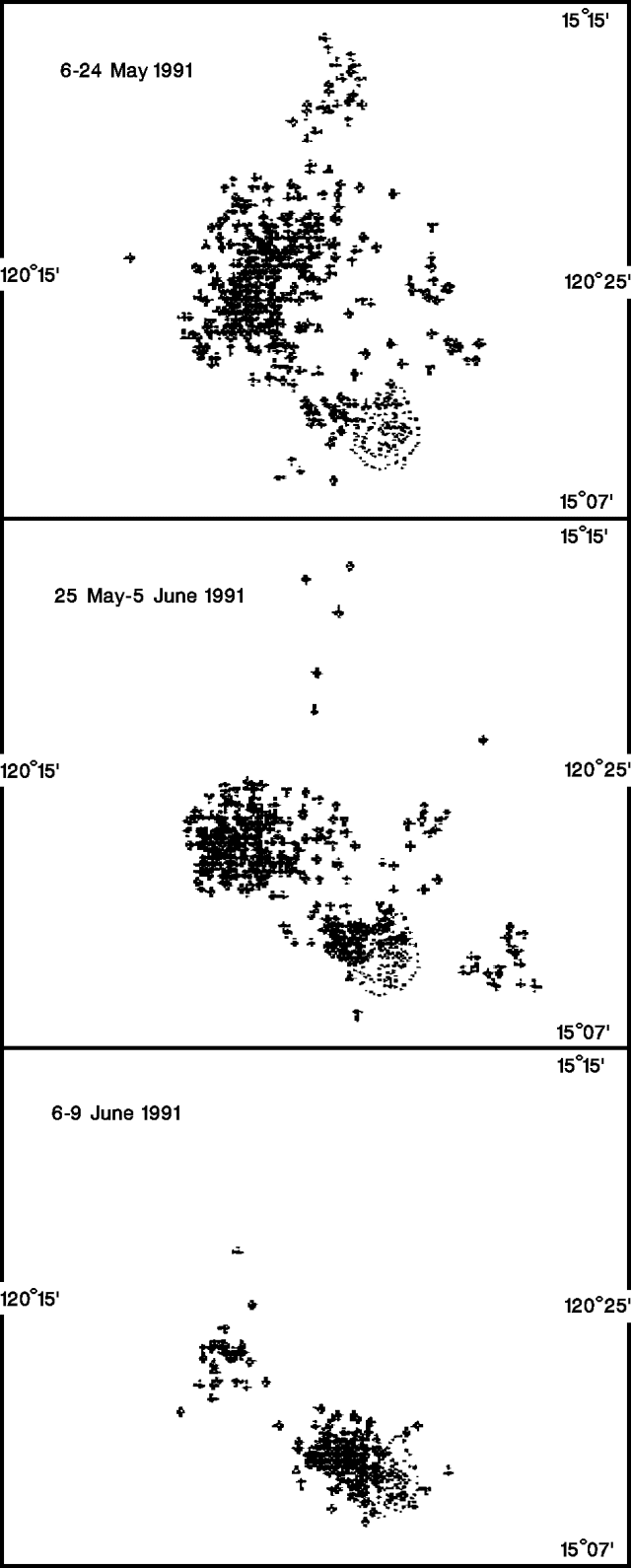 |
Figure 5. Epicenters of earthquakes (crosses) recorded near Pinatubo (dotted outline), 6-24 May (top), 25 May-5 June (middle), and 6-9 June (bottom) 1991. Courtesy of David Harlow. |
Increased activity, late May-early June. Emissions from the vents increased in volume, with two large pulses observed on 25 and 26 May. Some ash was reported. SO2 flux, measured by COSPEC, rose from 500 t/d on 13 May to 5,000 t/d on 28 May, but dropped again to 1,700 t/d on 30 May and 1,800 t/d on 3 June. Seismicity continued slightly NW of the fumaroles (at 2-6 km depth), and an increasing number of earthquakes were recorded directly beneath the fumaroles (at 0-2 km depth) at the end of May. A "blast event" during the evening of 3 June produced ash and was immediately followed by harmonic tremor lasting 30 minutes. A similar tremor event was recorded the next day at around 1200. The SO2 flux had dropped to 280 t/d by 4 June.
Increased earthquake amplitudes and more frequent tremor were noted in early June. PHIVOLCS issued an Alert Level 3 announcement (indicating a possible major pyroclastic eruption within 2 weeks) on 5 June. Geologists interpreted the shallow seismicity and harmonic tremor to be caused by the upward movement of magma, and the drop in gas flux to suggest a blockage of escaping gas and an accompanying pressure buildup.
Seismicity increased over the next few days, from about 1,000 to 2,000 recorded earthquakes/day, associated with 25 microradians of tilt recorded on the upper E flank. Most epicenters were just NW of the summit. An explosion at 1640 on 7 June from the main vent near the center of the line of fumaroles (at the head of the Maronut River) ejected ash to 8,000 m height. The explosion occurred about 40 minutes into an hour-long episode of harmonic tremor. At 1700, PHIVOLCS announced an increase to Alert Level 4 (eruption possible within 24 hours) and ordered the evacuation of an area up to 21 km from the summit. About 12,000 residents were evacuated (from Zambales, Tarlac, and Pampanga Provinces).
Ash emission continued the next day, producing plumes about 5,000 m high and depositing ash to 25 km W. Helicopter reconnaissance in the morning confirmed the extrusion of a lava dome (100 x 60 m, and 30 m high) near the main vent on the volcano's N flank. The press reported that ash emission was continuing on 9 June (table 1) from two craters, with ash falling as far as the South China Sea (~35 km W). Seismographs near the volcano recorded continuous harmonic tremor.
Table 1. Eruptive episodes from Pinatubo, 9-17 June 1991. Times of eruption onsets are from PHIVOLCS and the USGS; times of initial satellite observations of eruptive episodes are shown in the second column. Plume altitudes are from NOAA. Altitudes given in the text are generally ground-based, and often higher than the NOAA estimates. Satellite data were compiled by James Lynch, NOAA/NESDIS, based on analysis of visible/infrared weather satellite imagery. Data in this table are very preliminary and will change as analyses of ground and satellite observations continue.
| Date | Eruption Time | Detection Time | Maximum Plume Altitude | Direction of Movement | Horizontal Extent (time after eruption) |
| 09 Jun 1991 | -- | 0931 | 2 km | NW | less than 1 x 10⁴ km2 (2 hrs) |
| 11 Jun 1991 | -- | 1631 | 3.5 km | WSW | less than 1 x 10⁴ km2 (2 hrs) |
| 12 Jun 1991 | 0851 | 0931 | 17-19 km | WSW | 5.5 x 10⁴ km2 (8 hrs) |
| 12 Jun 1991 | 2250 | 2331 | 17-19 km | WSW | 1.1 x 10⁵ km2 (8 hrs) |
| 13 Jun 1991 | 0840 | 0931 | 17-19 km | WSW | 1 x 10⁵ km2 (6 hrs) |
| 14 Jun 1991 | 1309 | 1331 | 20-22 km | WSW | 5 x 10⁴ km2 (4 hrs) |
| 14 Jun 1991 | 1408 | 1431 | 20-22 km | WSW | 6 x 10⁴ km2 (5 hrs) |
| 14 Jun 1991 | 1853 | 1931 | 23-25 km | WSW | 7.5 x 10⁴ km2 (6 hrs) |
| 14 Jun 1991 | 2018 | Indistinguishable from 1853 eruption on satellite images. | |||
| 14 Jun 1991 | 2321 | 2331 | 23-25 km | WSW | 5 x 10⁴ km2 (3 hrs) |
| 15 Jun 1991 | 0114 | 0131 | 23-25 km | WSW | 1.5 x 10⁵ km2 (4 hrs) |
| 15 Jun 1991 | 0220 | Indistinguishable from 0114 eruption on satellite images. | |||
| 15 Jun 1991 | 0555 | 0631 | 20-22 km | WSW | 1.1 x 10⁵ km2 (3 hrs) |
| 15 Jun 1991 | 0611 | Indistinguishable from 0555 eruption on satellite images. | |||
| 15 Jun 1991 | 0809 | 0831 | 20-22 km | WSW | 1.1 x 10⁵ km2 (3 hrs) |
| 15 Jun 1991 | 0831 | Indistinguishable from 0809 eruption on satellite images. | |||
| 15 Jun 1991 | 1027 | 1031 | 35-40 km | WSW | 1 x 10⁶ km2 (12 hrs) |
| 15 Jun 1991 | 1027 | 1031 | 35-40 km | WSW | 1.5 x 10⁶ km2 (18 hrs) |
| 15 Jun 1991 | 1027 | 1031 | 35-40 km | WSW | 2.2 x 10⁶ km2 (24 hrs) |
| 15 Jun 1991 | 1027 | 1031 | 35-40 km | WSW | 2.7 x 10⁶ km2 (36 hrs) |
| Initial, strongest phase of the climactic eruption, apparent on infrared imagery until 2131; column over the volcano reached 35-40 km height; extensive ash plume at 25-30 km. Ash from this phase comprised >95% of the extensive plume. | |||||
| 15 Jun 1991 | 1117 | Indistinguishable from the 1027 eruption on satellite images. | |||
| 15 Jun 1991 | 1221 | Indistinguishable from the 1027 eruption on satellite images. | |||
| 15 Jun 1991 | 1252 | Indistinguishable from the 1027 eruption on satellite images. | |||
| 15 Jun 1991 | 1342 | Indistinguishable from the 1027 eruption on satellite images. | |||
| 15 Jun 1991 | 1342 | 2231 | 26-28 km | WSW | -- |
| The second phase of the climactic eruption continued until 0231 on 16 Jun, with a ball-shaped column over the volcano. | |||||
| 16 Jun 1991 | -- | 0331 | 23-25 km | WSW | -- |
| The third phase, smaller than the second,, was characterized by a wedge-shaped plume from the volcano; apparent on satellite imagery until 0731. | |||||
| 16 Jun 1991 | -- | 1031 | 5-6 km | WSW | 1.5 x 10⁴ km2 (3 hrs) |
| 16 Jun 1991 | -- | 1231 | 5-6 km | WSW | less than 1 x 10⁴ km2 (2 hrs) |
| 16 Jun 1991 | -- | 1431 | 5-6 km | WSW | 1.5 x 10⁴ km2 (3 hrs) |
| 16 Jun 1991 | -- | 2031 | 4-5 km | WSW | less than 1 x 10⁴ km2 (2 hrs) |
| 17 Jun 1991 | 1300 | 1300 | 3.5 km | WSW | less than 1 x 10⁴ km2 (2 hrs) |
The evacuation of Clark Air Base (~15 km E of the volcano) was ordered by the U.S. Air Force at 0500 on 10 June. Almost 14,500 servicemen and their families were moved to Subic Bay Naval Base (30 km SSW), while 1,500 personnel remained at Clark. Preliminary hazard maps placed Clark Air Base at the E edge of pyroclastic-flow hazard zones, and flanked by potential mudflow hazard zones. Voluminous ash-laden steam clouds were emitted on 11 June.
Initial strong explosions, 12-early 15 June. A tephra column rose to about 20 km on 12 June, as an explosive episode at 0851 signalled the start of a major pyroclastic phase. The explosions were preceded by around 12-16 hours of continuous tremor and several smaller explosions. Numerous shocks had been felt by scientists working on the volcano earlier in the morning. Pyroclastic flows advanced at least 5 km and perhaps as much as 15 km down the Maronut, O'Donnell, and Marella Rivers on the NW, N, and SW flanks of the volcano, respectively. Six hundred of the remaining 1,500 military personnel at Clark Air Base were evacuated and thousands of people fled adjacent Angeles (population 300,000). All residents within a 20-km radius of the volcano were warned to leave.
The press reported that a smaller explosion occurred at 1149, then explosive activity declined after a few hours. Prevailing winds carried the eruption plume WSW, depositing ash more than 30 km away, but ashfall also apparently occurred N of the volcano, reportedly covering an aerial gunnery range. A small rain-induced mudflow occurred in the Maronut River valley at about 1830 on 12 June.
Weather satellite images showed that the eruption plume had separated from the volcano by 1330, after reaching about 330 km length (figure 6). By 1830, winds had sheared the plume into three different layers; material at 15-18 km altitude traveling WSW at 100 km/hour; at 6-9 km altitude, W at 55 km/hour; and at 6-9 km altitude, WNW at 35 km/hour. The Nimbus-7 satellite's TOMS instrument detected a significant amount of SO2 during its pass over the area about 2.5 hours after the onset of the explosion. Aviation authorities warned aircraft to avoid the plumes and closed several air routes W of the volcano (A461, A583, B460, R77, R93, R468, and R471).
 |
Figure 6. Infrared image from the NOAA 10 polar-orbiting weather satellite on 15 June at about 1830, showing the massive cloud from the climactic explosive phase. Temperature estimates suggest that the main body of the plume is at about 30 km altitude, with the eruption column directly over the volcano rising to 35-40 km. The apparent boundary between sections of the cloud is probably a sampling artifact. Material NE of the volcano is probably at a lower altitude than the bulk of the cloud to the W and SW. Numerous faint bands are evident within the plume in false-color versions of the image. Courtesy of NOAA/NESDIS. |
Another large explosive pulse occurred between 2250 and 2305 on 12 June, producing an eruption column that briefly rose to 25 km altitude before declining to a sustained elevation of about 20 km. Tephra fell to the W, NW, and SW, with pumice lapilli falling to 15 km distance, and coarse sand-sized tephra to more than 20 km from the volcano. A similar explosion at 0840 on 13 June lasted for 8 minutes and sent an ash column to 25 km altitude, following about an hour of long-period earthquakes. Satellite images showed large plumes extending [WSW] from the volcano after both explosions.
After a lull of about 28 hours, explosions resumed at 1309 on 14 June, ejecting tephra to 25 km altitude. Intermittent small pulses occurred at 1353 and 1408. Pyroclastic flows in the NW flank's Maronut valley extended 15 km to Sitio Ugik, site of an evacuation camp until increased shallow seismicity prompted additional warnings just before the start of the latest series of explosions. Ash fell to the S, SE, and SW. Another explosion at 1853 sent ash to 24 km altitude and additional pyroclastic flows to the NW. Strong rains during several of the explosive pulses generated mudflows in drainages where pyroclastic-flow deposits and airfall tephra had previously been emplaced.
By 14 June, 79,000 people had been evacuated, including about 15,000 from Clark Air Base. Civil Defense officials reported that four people had been killed, 24 injured, and four were missing in the series of explosions.
A small explosion at 2018 on 14 June sent an ash cloud to 6 km. A period of harmonic tremor preceded a strong explosion at 2321 that produced a column to >20 km [see also 16:6]. Ashfall was reported in San Marcelino (25 km SW) and San Narciso (30 km WSW). Explosions on 15 June at 0114 and about 0220 produced pyroclastic flows that moved down the SW flank.
Climactic explosions, 15-16 June. An explosion at 0555 on 15 June fed a 20-22 km-high ash column [see also 16:6], marking the onset of strong sustained activity that included the climactic explosions and lasted until early 16 June. Effects of the eruption were exacerbated by heavy rains and strong winds from typhoon Yunya. Much of the summit region was removed by explosions or collapse, leaving a caldera 2-3 km in diameter centered slightly north of the former summit.
Pyroclastic flows generated by the first 15 June explosion extended 8-10 km down the N, NNE, NNW flanks. Additional explosions were reported at 0611, 0809, and 0831. Before the strongest activity began, PHIVOLCS expanded the radius of the official danger zone from 30 to 40 km and expressed concern about the possibility of a caldera-forming eruption. The expanded danger zone included Clark Air Base, Subic Naval Base, and their neighboring cities of Angeles and Olongapo. Additional evacuees brought the total to about 200,000. Several thousand military dependents were sent back to the United States.
Satellite data suggested that the climactic phase began with an explosion detected by a nearby barograph at 1027, and continued with recorded explosions at 1117, 1221, and 1252, although ground reports indicated that the strongest activity started with an explosion at 1342 (table 1). A column remained fixed over the volcano through 2131, feeding a massive cloud (figure 7). Comparison of satellite-derived eruption column temperatures with atmospheric temperature profiles from nearby radiosondes yielded an altitude of 25-30 km as the cloud spread WSW toward mainland Asia, and elevations of 35-40 km for the eruption column over the volcano. The maximum altitude of a plume can be underestimated by this technique if its temperature has not fully equilibrated with that of the surrounding air, or if more diffuse material extends above the plume's densest region. Satellite data suggest that more than 95% of the cloud was produced by this 12-hour phase. Visible-band images showed ejection of very dark-colored material throughout the day (from 0631 until 1631), in contrast to the light-colored plumes generated by other phases of the eruption. Noticeably less violent activity, seen on images from 2231 on 15 June until 0231 on 16 June, sustained a ball-shaped cloud over Pinatubo at 26-28 km altitude. Activity had declined further during a third period, from 0331 through 0731, when a wedge-shaped plume extended from the volcano.
 |
Figure 7. Infrared image from the NOAA 10 polar orbiting weather satellite on 15 June at about 1830, showing the massive cloud from the climactic explosive phase. Temperature estimates suggest that the main body of the plume is at about 30 km altitude, with the eruption column directly over the volcano rising to 35-40 km. The apparent boundary between sections of the cloud is probably a sampling artifact. Material NE of the volcano is probably at lower altitude than the bulk of the cloud to the W and SW (figure 8). Numerous faint concentric bands are evident within the plume in false-color versions of the image. |
The bulk of the tephra fell to the SE, S, and SW, but airfall distribution was complicated by the typhoon's winds. Ash was carried by the typhoon to Palawan Island, 500 km SSW of the volcano. The press reported slight ashfall 150 km S (in Batangas Province) and clumps of mud fell on Clark Air Base, Angeles, and the volcano's W flank. Some falling pumice was reportedly apricot-sized. Pumice the size of marbles fell 33 km SSW (at Olongapo) where tephra fall reached 15-30 cm and more than 30 injuries and some deaths were reported. The cloud darkened Manila by 1545, 3 hours before its usual nightfall, although most ashfall amounts there were less than about 1 cm [see also 16:6].
The stratospheric cloud expanded rapidly WSW, and by 1030 the next day, its leading edge had reached the Bangkok area, more than 2,000 km away (figure 8). Preliminary Nimbus-7 satellite data showed very high concentrations of SO2 over a broad area (figure 9), with a total mass that appeared to be approximately double that of the 1982 injection from El Chichón. Light ashfalls were reported in southern Vietnam (from Da Nang to the Mekong Delta, 1,400 km W-1,800 km WSW), northern Borneo (Sabah and Sarawak, 1,000-2,000 km SW), and Singapore (2,500 km SW). By 23 June, a nearly continuous zone of enhanced SO2 as much as 30° wide extended from south of Indochina about 11,000 km to central Africa (figure 10). A small zone of apparent aerosol material had reached about 40°W. [See the Atmospheric Effects chapter for more information about the stratospheric cloud].
 |
Figure 8. Sketch of the major eruption cloud from Pinatubo as seen on satellite imagery on 16 June at about 1030, about 21 hours after the onset of strongest activity, and 1 hour before the SO2 data in figure 9. Courtesy of SAB. |
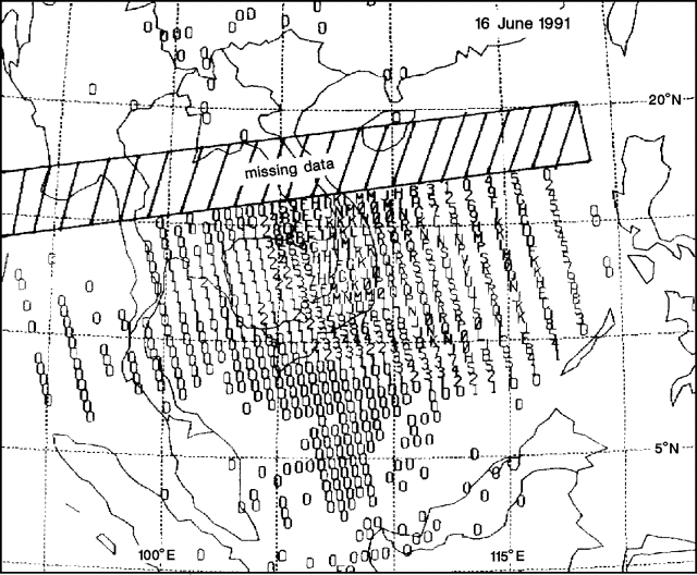 |
Figure 9. Preliminary SO2 data from the Total Ozone Mapping Spectrometer on the Nimbus-7 satellite, showing the major eruption cloud from Pinatubo on 16 June at about 1130, 22 hours after the start of the climactic explosions. Each number or letter represents the average SO2 value within an area 50 km across. 0 = 10-35 milliatmosphere-cm (100-350 ppm-m), 1 = 36-60 matm-cm, 2 = 61-85 matm-cm, etc.; 9 is followed by A, B, etc. Data were lost in the barred zone. Courtesy of Scott Doiron. |
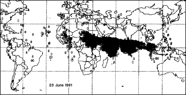 |
Figure 10. Preliminary SO2 data from the Total Ozone Mapping Spectrometer on the Nimbus-7 satellite, showing the major eruption cloud from Pinatubo on 23 June, eight days after the climactic phase. The main body of the cloud, 11,000 km long, has reached central Africa, but a smaller advance segment apparently extended over the eastern Atlantic Ocean, bisected by the 30°W meridian. Only values above 18 matm-cm are shown. Highest values within the dense cloud reached about 75 matm-cm (over Saudi Arabia). Courtesy of Scott Doiron. |
Smaller explosions continued during the next several days, but the strongest activity appeared to have ended, and people began to return to their homes. PHIVOLCS reported three periods of ash emission accompanied by tremor on 17 June. Satellite data revealed a small explosion at 1300 and a column to 5-6 km altitude was observed.The Worldwide Standardized Seismic Net detected shallow earthquakes near Pinatubo on 15 June at 1539 (M 4.9), 1831 (M 4.4), 1841 (M 5.4), 1911 (M 4.6), 1915 (M 5.5), and 2026 (M 4.7), on 16 June at 0349 (M 4.9), 0359 (M 4.8), 1008 (M 5.6), 1458 (M 4.9), 1751 (M 5.1), and 2127 (M 4.9), on 17 June at 0441 (M 5.3) and 2333 (M 4.6), and on 18 June at 1120 (M 4.6).
On 18 June geologists reported preliminary cumulative ashfall thicknesses of 15-30 cm at Clark Air Base, 15-30 cm in Olongapo, and an unconfirmed 35.5 cm in some parts of SW Luzon. At a site along the Abacan River, 37 km E of the summit, debris-flow deposits were sandwiched between a coarse basal layer and finer, sand-sized tephra. Several homes at this site had been inundated, and several others swept away by lateral stream erosion, with some resulting casualties. A similar situation was found at a second site along the Baluyot River, 34 km ESE of the summit. Several homes had been lost or buried by mud, but no deaths had occurred.
The leading edge of typhoon Yunya had reached the area by 14 June at about 2000, and strong storms began moving over the volcano at about 0500 on 15 June. The storm had weakened to light-moderate showers 24 hours later, but these persisted through the 16th. Heavy rains soaked the recently fallen tephra, adding substantially to its weight, and the wet tephra soon hardened to a concrete-like material, making it very difficult to remove. Numerous roof and building collapses resulted, and were responsible for many of the casualties from the combined effects of the eruption and typhoon. As of 19 June, the death toll had risen to more than 300.
The 15 June activity forced closure of Manila's international and domestic airports, which remained closed to arriving jet aircraft through 18 June. A limited number of outgoing flights were permitted beginning early 19 June, and propeller-driven aircraft, less vulnerable to the effects of ash clouds, offered limited air service to and from Manila. Preliminary reports indicate that [14] jets encountered ash during the eruption, most on 15 June (table 2). All landed safely, but some sustained engine and/or exterior damage.
Table 2. Preliminary summary of aircraft encounters with clouds from Pinatubo, 12-18 June 1991. Courtesy of T. Casadevall. [Including additional encounters reported in BGVN 16:07.]
| Date | Time | Duration | Location | Comments |
| 12 Jun 1991 | -- | 3 minutes | Descent into Manila | -- |
| 13 Jun 1991 | 0030 | 20 minutes | S China Sea | Electrostatic discharge on windscreen; no damage. |
| 14 Jun 1991 | early AM | 15 minutes | 750 km W of Pinatubo, 11 km altitude | No significant damage. |
| 14 or 15 Jun 1991 | -- | 29 minutes | -- | Two engines replaced; impact damage and ash buildup on engines. |
| 15 Jun 1991 | -- | 15-20 minutes | -- | Flew through "heavy ash;" cockpit and cabin contaminated by ash. |
| 15 Jun 1991 | early AM | -- | 1,100 km W, 9 km altitude | All four engines damaged. |
| 15 Jun 1991 | -- | 12 minutes | 10.5 km altitude | Temperatures of all four engines rose and fluctuated; sparks from windows; ash hit aircraft; no significant exterior or engine damage. |
| 15 Jun 1991 | 1600 | -- | Approach to Manila from S Vietnam | Much ash in engines; exterior abrasion. |
| 15 Jun 1991 | evening | -- | Leaving Manila | Black marks on exterior of left wing. |
| 15 Jun 1991 | 2347 | -- | Approach to Manila from S Vietnam | Ash, sulfur odor, electrostatic discharge, and blue-green light. No significant damage |
| 16 Jun 1991 | 0130 | 25 minutes | S China Sea | Electrostatic discharge on windscreen; no damage. |
| 16 Jun 1991 | 0310 | 30 minutes | S China Sea | Electrostatic discharge on windscreen; no damage. |
| 17 Jun 1991 | -- | -- | -- | Engine 3 shutdown; heavy ash buildup in engines. |
| 18 Jun 1991 | 0200 | -- | 11 km altitude | Engine 1 stalled, engine 4 lost power; descended to 9 km to restart. Engine 1 replaced. |
Further References. Pinatubo Volcano Observatory Team, 1991, Lessons from a major eruption: Mt. Pinatubo, Phillipines: EOS, v. 72, p. 545, 552-3, 555.
Woods, A. and Self, S., 1992, Thermal disequilibrium at the top of volcanic clouds and its effect on estimates of the column height: Nature, v. 355, p. 628-630.
Geological Summary. Prior to 1991 Pinatubo volcano was a relatively unknown, heavily forested lava dome complex located 100 km NW of Manila with no records of historical eruptions. The 1991 eruption, one of the world's largest of the 20th century, ejected massive amounts of tephra and produced voluminous pyroclastic flows, forming a small, 2.5-km-wide summit caldera whose floor is now covered by a lake. Caldera formation lowered the height of the summit by more than 300 m. Although the eruption caused hundreds of fatalities and major damage with severe social and economic impact, successful monitoring efforts greatly reduced the number of fatalities. Widespread lahars that redistributed products of the 1991 eruption have continued to cause severe disruption. Previous major eruptive periods, interrupted by lengthy quiescent periods, have produced pyroclastic flows and lahars that were even more extensive than in 1991.
Information Contacts: R. Punongbayan, PHIVOLCS; R. Janda and J. Ewert, CVO; SAB; Scott Doiron, GSFC; Chris Newhall and Ellen Limburg-Santistevan, USGS Reston; David Harlow, USGS Menlo Park; T. Casadevall, USGS Denver; Nicholas Krull, FAA; Tom Fox, ICAO; NEIC; AP; UPI; Reuters.