Report on Karthala (Comoros) — June 1991

Bulletin of the Global Volcanism Network, vol. 16, no. 6 (June 1991)
Managing Editor: Lindsay McClelland.
Karthala (Comoros) Seismic swarm precedes phreatic explosion; press reports of ash/lava eruption incorrect
Please cite this report as:
Global Volcanism Program, 1991. Report on Karthala (Comoros) (McClelland, L., ed.). Bulletin of the Global Volcanism Network, 16:6. Smithsonian Institution. https://doi.org/10.5479/si.GVP.BGVN199106-233010
Karthala
Comoros
11.75°S, 43.38°E; summit elev. 2361 m
All times are local (unless otherwise noted)
Widely distributed news reports of ash and lava emission during the evening of 2 July proved incorrect. As of mid-July, the only documented eruptive activity had been a phreatic explosion on the 11th. According to the press, some villages around the base of the volcano were evacuated, but many fewer residents fled than the tens of thousands initially reported [see 16:8]. The eruption followed three months of increasing seismicity monitored by a joint group from the Centre National de Documentation et de Recherche Scientifique des Comores (CNDRS), the Univ de la Réunion, and the IPGP. The following is from their report. [See 16:8 for additional details].
An average of 3-5 seismic events/month were recorded from the start of monitoring in June 1988 until April 1991. "At the beginning of April, a slight increase in seismicity was noticed, with events mainly centered under the summit caldera from 0-2 km below sea level [see also 16:8]. The rate of seismicity progressively increased from an average of 5-10 events/day in May to 20/day in June, reaching 40/day by the end of June. The earthquakes occurred along a roughly N-S axis below the summit caldera at 0-1 km below sea level. Deformation measurements, using a 10-station dry-tilt network in the summit caldera, indicated inflation of ~ 20 µrads.
"At 1645 on 30 June a seismic crisis began with events centered below the S part of the caldera and the volcano's S flank. During the night of 30 June, many shocks were felt by residents of the SW part of the island. Seismic activity continued 1-2 July, with both short- and long-period events occurring at average rates of 60-100/hour. Some of the short-period events reached M 2.5-3. One M 3.1 earthquake (at 0708 on 2 July) was felt in the SE part of the island (in the Foumbouni area; figure 1). This intense seismic activity has caused many people living in the SW to move to Moroni, the capital and island's largest city.
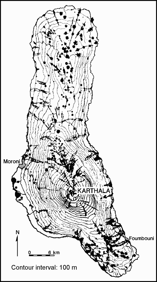 |
Figure 1. Topographic map of Karthala, after Strong and Jacquot (1970). |
"The seismic crisis continued until 10 July, with the number of earthquakes reaching 250/hour. After several hours of relative calm, a phreatic eruption occurred at 0330 on 11 July [but see 16:8], after which the number of earthquakes returned to ~100/hour. During overflights of Choungou Chahalé Crater (summit area), it was observed that the rim of the S half of the summit caldera was covered by ash and blocks of old material. The crater was filled with gas that stagnated in its bottom. A sound like a lava fountain [but see 16:8] was audible, but no lava fountain was visible. The same day, seismometers recorded ~40-60 earthquakes/hour, most of M <2. Some of M >3 were felt by the population."
Reference. Strong, D.F., and Jacquot, C., 1970, The Karthala Caldera, Grande Comore: BV, v. 34, p. 663-680.
Geological Summary. The southernmost and largest of the two shield volcanoes forming Grand Comore Island (also known as Ngazidja Island), Karthala contains a 3 x 4 km summit caldera generated by repeated collapse. Elongated rift zones extend to the NNW and SE from the summit of the Hawaiian-style basaltic shield, which has an asymmetrical profile that is steeper to the S. The lower SE rift zone forms the Massif du Badjini, a peninsula at the SE tip of the island. Historical eruptions have modified the morphology of the compound, irregular summit caldera. More than twenty eruptions have been recorded since the 19th century from the summit caldera and vents on the N and S flanks. Many lava flows have reached the sea on both sides of the island. An 1860 lava flow from the summit caldera traveled ~13 km to the NW, reaching the W coast to the N of the capital city of Moroni.
Information Contacts: P. Bachélery, Univ de la Réunion; J-L. Klein, CNDRS, RFI des Comores; J-L. Cheminée, IPGP; UPI; AP; Reuters.