Report on Langila (Papua New Guinea) — June 1991

Bulletin of the Global Volcanism Network, vol. 16, no. 6 (June 1991)
Managing Editor: Lindsay McClelland.
Langila (Papua New Guinea) Frequent Vulcanian explosions
Please cite this report as:
Global Volcanism Program, 1991. Report on Langila (Papua New Guinea) (McClelland, L., ed.). Bulletin of the Global Volcanism Network, 16:6. Smithsonian Institution. https://doi.org/10.5479/si.GVP.BGVN199106-252010
Langila
Papua New Guinea
5.525°S, 148.42°E; summit elev. 1330 m
All times are local (unless otherwise noted)
"Crater 3 . . . produced 1 to >40 Vulcanian explosions/day in June. The explosions produced dark grey vapour and ash clouds or columns, resulting in light ashfalls over the NW flank of the volcano and to coastal villages (10-15 km distant). Villagers were also shaken by the airwaves of the strongest explosions. Night activity consisted of weak red glow, with the largest explosions producing a short-term brighter glow between 5 and 16 June.
"Crater 2 released weak to moderate white vapour emissions plus occasional grey ash and blue vapours. The crater produced one loud Vulcanian explosion on 28 June, accompanied by an ashfall. A steady weak night glow was visible over the crater for much the same period as at Crater 3 (3-17 June). After a 10-day absence, night glow reappeared at Crater 2 on 28 June, following its throat-clearing Vulcanian explosion. Two days later, night glow also returned to Crater 3.
"The daily number of Vulcanian explosions from Crater 3 reached its maximum level of >30 between the 15th and 19th, coinciding with the absence of night glow at both craters (figure 3). A seismograph 9 km away (CGA), which previously recorded ~10% of the explosion earthquakes detected by the summit station (LAN), started to record an increasing proportion of these events (to >50%)."
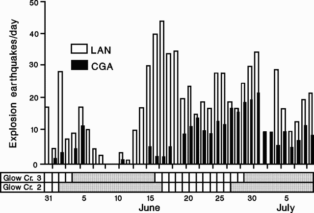 |
Figure 3. Number of explosion earthquakes/day recorded at Langila's summit seismic station (LAN) and a second station (CGA) 9 km away, late May-early July 1991. Periods of glow at craters 2 and 3 are shown by shaded areas along the bars at bottom. Courtesy of RVO. |
Geological Summary. Langila, one of the most active volcanoes of New Britain, consists of a group of four small overlapping composite basaltic-andesitic cones on the lower E flank of the extinct Talawe volcano in the Cape Gloucester area of NW New Britain. A rectangular, 2.5-km-long crater is breached widely to the SE; Langila was constructed NE of the breached crater of Talawe. An extensive lava field reaches the coast on the N and NE sides of Langila. Frequent mild-to-moderate explosive eruptions, sometimes accompanied by lava flows, have been recorded since the 19th century from three active craters at the summit. The youngest and smallest crater (no. 3 crater) was formed in 1960 and has a diameter of 150 m.
Information Contacts: P. de Saint-Ours, RVO.