Report on Pinatubo (Philippines) — June 1991

Bulletin of the Global Volcanism Network, vol. 16, no. 6 (June 1991)
Managing Editor: Lindsay McClelland.
Pinatubo (Philippines) Continued ash emission with pulses to 15 km; typhoons trigger large lahars, leaving thousands homeless
Please cite this report as:
Global Volcanism Program, 1991. Report on Pinatubo (Philippines) (McClelland, L., ed.). Bulletin of the Global Volcanism Network, 16:6. Smithsonian Institution. https://doi.org/10.5479/si.GVP.BGVN199106-273083
Pinatubo
Philippines
15.13°N, 120.35°E; summit elev. 1486 m
All times are local (unless otherwise noted)
As of 26 July, the volcano was still emitting ash continuously to 3-6 km height, with occasional pulses to 15-16 km. Typhoon rains triggered large debris flows down rivers on all sides of the volcano, inundating many of the towns in figure 11. Preliminary estimates of the eruption's size suggest that it is larger than those of Mt. St. Helens (1980) and El Chichón (1982), the largest eruptions of the last decade, but smaller than those of Cerro Azul/Quizapú (1932), Katmai/Novarupta (1912) and Santa María (1902), the largest of the century.
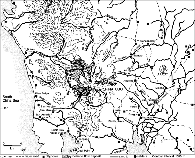 |
Figure 11. Map of Pinatubo and the surrounding area, showing towns, rivers, and roads. Preliminary pyroclastic-flow deposit distribution courtesy of Pinatubo Volcano Observatory. Contour interval is 1,000 m. |
Paroxysmal activity, products and deposits. Damage from the eruption made evaluation of its products slow and difficult. The following preliminary information has been compiled over several weeks from our correspondents' visual observations, fieldwork, and airphoto/satellite image interpretation. Data on the paroxysmal phase supplement the report in 16:5.
Infrared video taken from the Clark Air Base control tower on 14 June suggests that the summit began to fail at 2320 as a fissure propagated tangentially across the summit. An explosion and apparent lateral blast, at 0555 the next day, removed the summit and produced a 25-km ash column. This event marked the onset of strong sustained activity that lasted until early 16 June.
The eruption's most violent explosive phase began at 1342 on 15 June and continued for more than 15 hours at full strength, with 30-40-km columns feeding a massive cloud. Intense seismicity began at 1440 and was felt continuously (at Mt. Arayat ~40 km E) by 1700. This seismicity lasted until about 0000 on 16 June, and was probably associated with the explosions or collapse that formed a nearly circular caldera, 2 km in diameter. The caldera was offset slightly N of the former summit, and the new summit was 145 m lower than before the eruption. The caldera wall ranged in height from 150-200 m at the highest point to 0 m on the E side. In the caldera's NE corner, a cone-shaped feature, ~75 m in diameter and 10 m high, was observed on satellite images. By 20 June, this feature was no longer visible, and the floor of the caldera appeared deeply ash-covered and relatively smooth. A conical depression developed in the SE corner of the caldera, reaching 800 m in diameter by 8 July and continuing to grow. No dome had been identified as of 26 July. No vegetation remained within 1-2 km of the caldera and trees 6-7 km away were defoliated.
Tephra fell primarily to the SE, S, and SW, but airfall distribution was complicated by the typhoon's winds. Pumice to roughly 7 cm fell 25 km E (at Clark Air Base) and particles to roughly 1.5 cm fell 33 km SSW (at Olongapo). Within 3 km of the caldera rim, ash thicknesses averaged 1-2 m. Eruption volume estimates and detailed isopach information were not available as of 26 July. The pumices are porphyritic biotite-hornblende quartz latite, and preliminary analyses indicate 66% SiO2, and 1.6% K2O.
The quoted material below is from Pinatubo Volcano Observatory reports.
"Pyroclastic flows reached radial distances of 12-18 km from the vent (figure 11) and were accompanied by ash clouds whose deposits ranged in thickness from a few to tens of centimeters. Thick pyroclastic-flow deposits (locally in excess of 200 m) occur in main valleys at distances of 5-15 km from the caldera, and have caused surface-drainage diversions that may have severe consequences as the monsoon and typhoon season gets into full swing. Blockage of the Sacobia River on the NE flank has raised the level of that drainage about 12 m above the level of the Abacan River capture point, potentially tripling the source drainage area for the modified Abacan River.
"Such factors as high velocity, high mobility, and low density allowed pyroclastic flows to drain off proximal slopes, which are covered by only a thin, discontinuous veneer. The flows removed vegetation and, in many places, soil and colluvium. Rugged highlands to the NE and SE, which are incised by narrow, steep canyons that head on high ridges separated from Pinatubo, have pyroclastic-flow fills several meters to perhaps 20 m thick locally. These deposits have been eroded extensively and occur as small patches in relatively protected areas along the canyons. Their distribution in such isolated valleys attests further to the great mobility of the pyroclastic flows. Pyroclastic-flow deposits downstream from the major fills were apparently formed by relatively dense flows, because vegetation along the margins of many was only slightly scorched. Conspicuous features include secondary explosion craters, fumaroles, breakaway scarps, and small ponds in blocked tributaries." Satellite data indicated that several lakes, up to 4 km x 350 m, were formed about 7 km W and NW of the caldera. Pyroclastic flows down the Sacobia River valley reached 3 km NW of housing on Clark Air Base, but did not reach the base itself. Numerous houses were swept away or buried by pyroclastic flows, 2-3 km SW of the caldera.
Activity, 16 June-mid July. Following the paroxysmal explosions on 14-16 June, tephra emission decreased and seismicity dropped dramatically (figure 12). With the strongest activity apparently ended, the radius of the official danger zone was reduced to 20 km on 17 June. Ash was emitted continuously to 3-6 km height, with periods of more intense explosions to 10 km height typically lasting several hours but separated by 5-7 hours. On 28 June, explosions were observed pulsating every 5 minutes from different points on the crater floor. Explosions were most frequently observed in the S and SE parts of the caldera.
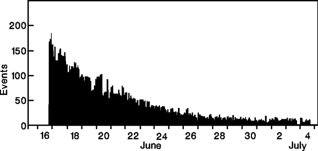 |
Figure 12. Hourly number of earthquakes at Pinatubo, 16 June-4 July 1991. No data are available for 15-late 16 June due to equipment saturation. Courtesy of PVO. |
Periods of sustained high-amplitude tremor and large long-period earthquakes (15-20/hour), represented as spikes on Realtime Seismic Amplitude Measurement (RSAM) plots, often coincided with higher ash ejection. A rough 7-hour periodicity was recognized for these spikes beginning about 7 July (figure 13). Ash emission during inter-eruptive periods (between spikes) gradually decreased and the repose period increased, before the pattern finally became irregular around noon on 11 July. This episode was accompanied by a coincident increase in seismic energy release (figure 14).
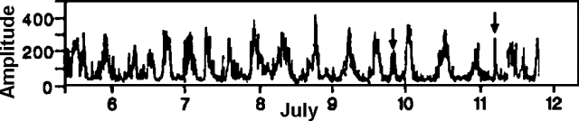 |
Figure 13. RSAM at Pinatubo, 5-11 July 1991. Arrows represent suspected lahar signals. Courtesy of PVO. |
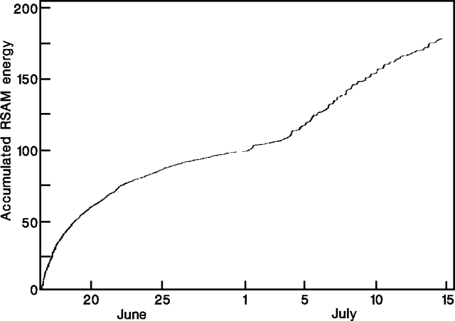 |
Figure 14. Accumulated RSAM energy at Pinatubo, 16 June-14 July 1991. Courtesy of PVO. |
Earthquakes were occasionally felt as far away as Manila. The largest of these (M 5.9) was at 1250 on 3 July, and was centered 6 km NE of the volcano at 6 km depth (in a previously near-aseismic location). Most earthquakes, however, were centered beneath the volcano, at depths ranging from 0 to >20 km, whereas focal depths before the cataclysmic activity did not exceed 8 km depth (figure 15).
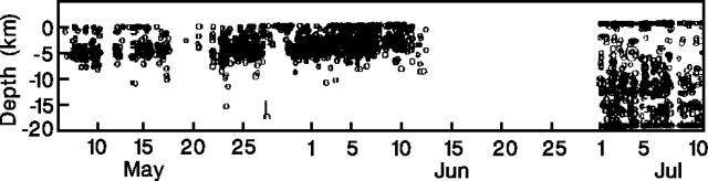 |
Figure 15. Depths of 2,080 earthquakes at Pinatubo, 6 May-9 July 1991. Data for 27-30 June are similar to those of early July. Courtesy of PVO. |
Rains triggered debris flows, ranging from landslides to hyperconcentrated flows, on all flanks of the volcano. Several of these flows were recorded seismically (figure13). On 23 June, at 2240-2330, a "hot" lahar was observed NW of the volcano on the Balintawak River near Poonbato. Hyperconcentrated flows were reported on the nearby Maronut River the next day, and to the SE (on the Pasig, Porac, and Gumain Rivers) on 30 June. Houses in Porac and Floridablanca (SE of Pinatubo) were buried up to roof level with volcanic debris. A lahar occurred on the Balintawak River the night of 30 June-1 July.
Large explosive episodes ejected ash clouds to 16 km height on 2 July, and explosive activity again intensified slightly on 7 July, ejecting ash clouds to 14-15 km height. Intense activity continued the next day and weather satellites observed clouds 14 km high at 0230-0250, >15 km high at 0700, 16 km high at 0800-0900, and about 15 km high at 1604. Eruption cloud heights of 15 and 16 km were measured on 7 and 8 July, respectively. Small, low-energy pyroclastic flows were observed billowing from within the caldera and travelling only a few hundred meters from the rim. Ash emission between explosive episodes was very low. SO2 fluxes, determined by COSPEC, were 5,190 t/d on 5 July, and 1,243 t/d on 9 July. Clear weather enabled the installation of several telemetered rain gauges. Observers reported hundreds of small ash avalanches off steep ridges into valleys. Periodic ash emissions to 15 km continued on the 17th, when the prevailing wind carried ash SE to Manila, closing the airport for two days.
Debris-flow activity, 7-10 July. Information about W-flank lahars in the next two sections is abstracted from a report by Kelvin Rodolfo.
In response to a 9 July warning of possible heavy rains, geologists were stationed at two W-flank sites to monitor rivers and warn downstream residents if lahars were detected. The next morning, an intense cloudburst in the headwaters of the Bucao River triggered a minor, dilute lahar. One team (10 km E of Botolan on the N bank of the Bucao River) heard a strong noise of rushing water and rolling boulders for 15 minutes before the head of the flow came into view at 0557. Approximately 25% of the channel was occupied by the flow. Velocities averaged 3.5 m/s (12.6 km/hour). Numerous boulders to 1.5 m were intermittently rolled and pushed by the flow at rates comparable to its velocity.
From a hazards perspective, geologists noted that the flow's most significant characteristic was its capacity to erode laterally. Along a straight stretch of channel, cutting rates from 1.6 to 6 minutes per meter of horizontal bank erosion were documented. Lateral erosion was by undercutting and slumping of blocks 1-6 m long, 1.5 m thick, and 0.3 to 1 m wide (average width, 0.5 m) that were continuously incorporated into the flow. Bank erosion rates were faster along an outer bend, ranging between 0.2 and 1.2 min/m, and averaging 0.9 min/m over 2 hours of observation and measurement. The lahar deposits behaved like quicksand, especially those with a high content of fine ash, and crossing them before they had some time to drain caused people and animals to sink knee-deep. Mayor Doble of Botolan reported that some trapped animals had died from starvation.
Mountain slopes partially cleansed of ash by runoff from moderate rain were green, as were portions of grasslands on the plains that escaped total burial. Farmers were impressed by the health of surviving plants.
East of the volcano, the press reported that lahars travelling down the Chico River (NE flank) deposited knee-deep mud in several villages on 10 July. At a village near Porac, flows broke through sandbags for the second time in 13 days, causing people to flee. The next day, debris flows traveled down the Pasig, Porac, and Gumain Rivers on the SE flank, causing extensive erosion in small tributaries.
A lahar observed on the Marimla River (ENE flank) on 15 July, was up to 50 m wide, 4 m deep, and highly erosive. Post-15 June wingwall and channelization efforts proved ineffective as the lahar breached the N levee downstream on the Bamban River (NE flank) in 3 places.
Typhoon-related debris-flow activity, 20-26 July. The first typhoon after the paroxysmal eruption passed N of Luzon 18-19 July. At 0900 on 18 July, in response to weather forecasts, geologists recommended that Lahar Alert 2 be issued for the W flank's Zambales region. Teams were sent to the Bucao and Santo Tomas rivers. A minor dilute lahar occurred from 2300 until 0630 the following morning, but was hardly noticeable at Botolan, and caused no damage.
After the typhoon, the threat of lahars persisted, with continued scattered thunderstorms around Pinatubo. Large lahars along various rivers E of Pinatubo buried sections of some towns (such as Guagua). W of Pinatubo, monitoring stations were established on the Bucao River east of Botolan, and at the junction of the Marella and Santo Tomas Rivers (threatening San Marcelino and nearby towns). Small, dilute lahars were observed on two evenings, but none was large enough either to escape its channels or to reach the sea.
Geologists cited three reasons for expecting strong rainfall to trigger serious flooding in all of coastal Zambales province. First, ash deposited on the steeper mountain slopes has been washed into creeks and rivers by the first rains, seriously reducing capacities of the drainages to hold water. Second, to clear the national highway, much of its ash cover was dumped by the roadside, choking many ditches. Third, during typhoons, large waves or tidal surges will effectively raise sea level, making it harder for rivers to enter the sea.
Installation of a USGS computer that receives telemetered rainfall data from instruments on Pinatubo's W flank will help warn people in Botolan, San Marcelino, and other towns threatened by lahars. Watchers at stations on the Bucao and Santo Tomas Rivers are equipped with two-way radios with which to contact threatened towns.
On the E side of the volcano, the press reported that large lahars on 20 July (related to typhoon Amy) destroyed more than 400 houses in Floridablanca, and buried more than 130 houses in Concepcion, forcing the evacuation of at least 1,200 people. This event brought the total number of houses damaged during the eruption to more than 80,000. Two days later, heavy rains from typhoon Brendan caused additional large lahars travelling 10 m/s at the slope breaks and 3 m/s at distal locations. Lahars to 3 m deep caused the evacuation of parts of 13 towns in Zambales (W flank), Tarlac, and Pampanga (E flank) provinces, with 2,000 initially fleeing from Santa Rita (just S of Concepcion) where 4,000 more were left stranded, unable to leave until the following morning. Evacuees from Pampanga province numbered about 10,000. Channel infilling and dike ruptures resulted in lahars up to 4 km wide on the Bamban River E of Concepcion, with similar activity along the O'Donnell, Abacan, Pasig, Porac, and Santo Tomas Rivers.
By 23 July, more than 60,000 people had fled their homes, with at least five killed during the previous two days. Mudflows, 5 m high, traveled through Concepcion at 8-11 m/s, sweeping several people away. Further lahars buried 11 villages near Sexmoan and damaged fish ponds, buried almost half of Santa Rita, and had completely silted up the Abacan River at the town of Mexico.
Debris flows continued to form on 25-26 July, with the onset of typhoon Caitlin. About 10,000 people evacuated Mexico and 308 houses were buried in 1.2 m of mud from flows down the Abacan River. A 30-m section was removed from the Mexico-Concepcion road. Swelling of the Santa Rita River caused 300 to flee Olongapo when houses were flooded waist deep. Flooding also occurred in Manila.
The press reported that by the 26th, 1.2 million people had either lost their homes or their livelihoods, 100,000 houses had been crushed or buried, and about 90,000 people remained in evacuation camps. Casualty reports ranged from 323 (with 40 missing), to more than 435.
Medical impact. The following is from Peter Baxter. The paroxysmal phase of the eruption caused the collapse of numerous buildings, and in some towns W of the volcano, destruction was complete. An estimated 250,000 people were evacuated, many moving to temporary camps. Efforts have been made to determine the medical hazards presented by the eruption, by characterizing ash composition and leachates, and measuring exposure to humans. Epidemiology teams from the U.S. Centers for Disease Control collected information on health and medical conditions at hospitals and evacuation camps, establishing programs to monitor food/water contamination and changing ash compositions. Preliminary information showed that ashfall was not yet a serious health problem. Heavy rains that coincided with the paroxysmal activity alleviated some ash problems by washing the suspended material out of the air. There had been no outbreaks of respiratory ailments, and surface water contamination was not a major problem since residents generally drink ground water. Concern was expressed that malaria, endemic on the W side of the volcano, might increase. There was additional concern for the mental health of people who have been forced to relocate several times and are now threatened by large mudflows.
Geological Summary. Prior to 1991 Pinatubo volcano was a relatively unknown, heavily forested lava dome complex located 100 km NW of Manila with no records of historical eruptions. The 1991 eruption, one of the world's largest of the 20th century, ejected massive amounts of tephra and produced voluminous pyroclastic flows, forming a small, 2.5-km-wide summit caldera whose floor is now covered by a lake. Caldera formation lowered the height of the summit by more than 300 m. Although the eruption caused hundreds of fatalities and major damage with severe social and economic impact, successful monitoring efforts greatly reduced the number of fatalities. Widespread lahars that redistributed products of the 1991 eruption have continued to cause severe disruption. Previous major eruptive periods, interrupted by lengthy quiescent periods, have produced pyroclastic flows and lahars that were even more extensive than in 1991.
Information Contacts: PVO, PHIVOLCS-USGS, Clark Air Base, Philippines; Kelvin Rodolfo, Univ of Illinois; Peter Baxter, Dept of Community Medicine, Fenner's, England; John Ewert, Edward Wolfe, and Richard Hoblitt, CVO; T. Casadevall, USGS Denver; Ellen Limburg-Santistevan, USGS Reston; Harvey Miller, Pearl Harbor CINCPACFLT, HI, USA; SAB; Manila Far East Broadcasting Company; AP; Reuters; UPI.