Report on Pinatubo (Philippines) — July 1991

Bulletin of the Global Volcanism Network, vol. 16, no. 7 (July 1991)
Managing Editor: Lindsay McClelland.
Pinatubo (Philippines) Ash emissions decreasing; typhoons trigger large lahars
Please cite this report as:
Global Volcanism Program, 1991. Report on Pinatubo (Philippines) (McClelland, L., ed.). Bulletin of the Global Volcanism Network, 16:7. Smithsonian Institution. https://doi.org/10.5479/si.GVP.BGVN199107-273083
Pinatubo
Philippines
15.13°N, 120.35°E; summit elev. 1486 m
All times are local (unless otherwise noted)
Activity declined through the third week of August, although periodic explosions continued to eject material to >15 km height. Heavy rains triggered large mudflows that traveled down all major drainage systems, destroying houses and resulting in numerous casualties. The number of people killed by the eruption, mudflows, and disease (in evacuation camps) now exceeds 500. The stratospheric aerosol cloud produced by the paroxysmal activity on 15-16 June continued to disperse.
Continuing activity, to 20 August. Declining seismicity was interrupted by a M 4.5-5 volcano-tectonic earthquake at 1456 on 26 July and several felt aftershocks. Ash emission continued, often accompanied by tremor during periods of increased plume heights. Two pulses of emissions to >7.5 km at 0136 and 0203, and one to 16.4 km (as determined by radar at Clark Air Base) at 1212 on 27 July, were accompanied by low-amplitude tremor. Aviation officials were notified within 15 minutes of the onset of this more energetic activity. Relatively dry weather continued through early August.
Seismicity continued a gradual downward trend (figure 16), with a decrease in amplitude and number of long-period events, and a decrease in seismic energy released (figure 17). Small upsurges in amplitude (RSAM) corresponded to long-period earthquakes. Ash emissions were rare and did not exceed 8 km height during 8-10 August and had fewer accompanying long-period events. Occasional high-frequency earthquakes were felt at Clark Air Base with intensities up to II. Mudflow signals were seismically recorded on the 10th.
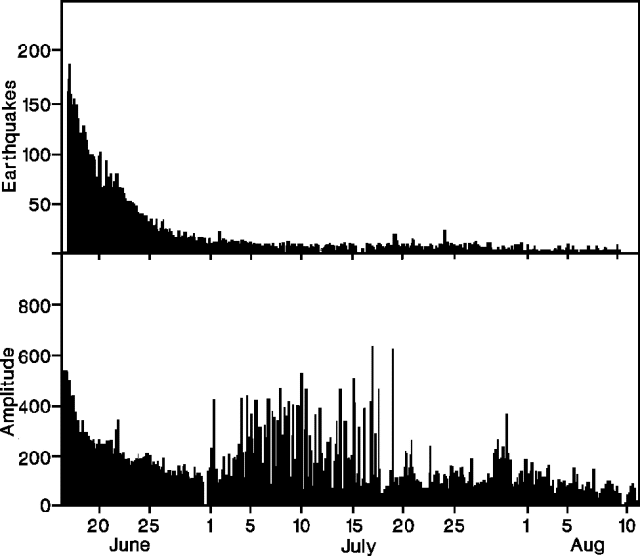 |
Figure 16. Number of earthquakes per 4 hours (top) and Realtime Seismic Amplitude Measurement (bottom) at Pinatubo, 16 June-11 August 1991. Courtesy of PHIVOLCS. |
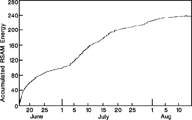 |
Figure 17. Accumulated RSAM energy at Pinatubo, 16 June-15 August 1991. Courtesy of PHIVOLCS. |
Heavy rain triggered large mudflows on 11 August. The press reported that more than 13,000 people fled their villages, and more than 1,000 houses were destroyed. The Gumain (SE flank) and Sacobia (E flank) Rivers rose an average 1.2 m, and 300 houses were damaged along the Abacan near Mexico (~45 km E of the summit). Five large ash emissions (average height 5 km) occurred on 12 August. United Airlines pilots reported an ash cloud to >15 km altitude at about 1300 on the 12th and to 12 km the following day at 1426.
High ash emissions (maximum plume height about 13 km) and mudflows were reported on 14 August. About 5,000 people evacuated Tabon in the Pampanga region (E flank), as 96 houses were washed away. The press reported debris to 3 m deep. Mudflows on the 18th prompted another large evacuation, with 3,000 fleeing 6 towns in the Pampanga and Tarlac regions (E flank).
On 20 August, the press reported that the largest mudflows since the start of the eruption killed 31 people (primarily in Santa Rita, ~40 km NE), bringing the number of mudflow-related deaths to over 100. Flows 5 m high reportedly traveled down ten rivers, damaging more than 9,000 houses and destroying three bridges. Up to 55,000 people evacuated their homes. Ash clouds rose to 12 km high.
The press reported that by 6 August, more than 46 people (mostly children and infants) had died of various illnesses (primarily diarrhea, measles, and broncho-pneumonia) in evacuation camps. This number had increased to nearly 200 (mostly Aeta tribesmen) by 18 August, and it was reported that almost 1,500 people in the camps were suffering from disease. By 20 August, more than 500 people had died since the start of the eruption according to press reports.
Field geology. Fieldwork and evaluation of the deposits from the paroxysmal activity of 15-16 June continued. A preliminary airfall isopach map was prepared by the PHIVOLCS MGB Lahar Task Force (figure 18), and the volume of material within the 10-cm isopach was estimated to be 0.47 km3. Ash leachates indicated chloride contents to almost 1,000 ppm, and fluoride contents under 10 ppm (table 3). Petrographic analysis of pumice samples revealed the presence of anhydrite micro-phenocrysts scattered in the matrix groundmass (Bernard, and others, 1991). Pyroclastic-flow deposit volumes were estimated to total roughly 7 km3. The following report by Alain Bernard describes one of the pyroclastic-flow deposits.
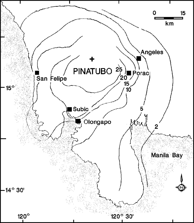 |
Figure 18. Preliminary isopach map of 12-16 June 1991 airfall deposits from Pinatubo. Isopachs are centimeters. Prepared by PHIVOLCS MGB Lahar Task Force. |
Table 3. Preliminary fluoride and chloride contents in Pinatubo ash leachates, 12 June-4 July 1991. Ash was washed for 12 hours in a 4:1 ratio of water (distilled-deionized water, pH 5.5) to ash. The 12, 15, and 22 June samples were collected by PHIVOLCS and reported "fresh fallen," the other samples were collected shortly after falling, during dry weather. Courtesy of Alain Bernard and PHIVOLCS.
| Date | Location | Distance from volcano | F- (ppm) | Cl- (ppm) | pH |
| 12 Jun 1991 | San Marcelino | 28 km | 0.3 | 212 | -- |
| 15 Jun 1991 | Bacoor-Cavite | 120 km | 9.8 | 208 | -- |
| 22 Jun 1991 | O'Donnell | 26.5 km | 0.4 | 475 | -- |
| 29 Jun 1991 | Binoclutan | 38 km | 1.6 | 991 | -- |
| 29 Jun 1991 | Mapanuepe | 19 km | 0.05 | 67 | 3.83 |
| 30 Jun 1991 | Botolan | 39.5 km | 0.4 | 803 | -- |
| 03 Jul 1991 | Iba | 44 km | 0.65 | 464 | -- |
| 03 Jul 1991 | Marella 1 | 10 km | 0.06 | 11 | 7.9 |
| 03 Jul 1991 | Marella 2 | 13 km | 0.1 | 50 | 7.2 |
| 03 Jul 1991 | Hot mudflow (on pyroclastic flow) | 8 km | 0.4 | 354 | 6.19 |
| 04 Jul 1991 | Poonbato | 23.5 km | 0.5 | 604 | -- |
| 03 Jul 1991 | Burgos-Ugik | 17 km | 0.6 | 699 | -- |
"A pyroclastic-flow deposit emplaced in the Marella River (reaching 15 km SW from the main crater) was visited on 3 July. It was still degassing, with numerous rootless fumaroles present even at low altitude at the end of the deposits. The gases emitted were mostly steam, but minor amounts of SO2 (and probably H2S) were present, since incrustations of native sulfur were observed at the mouths of these fumaroles. Strong odors of burned wood (charcoal) were also perceptible in some places, and associated with black-brown deposits at the surface of the pyroclastic-flow deposit resulting from some pyrolysis of wood buried at shallow depth beneath the deposit. Maximum temperatures of the fumarole were close to boiling, 98-99.5°C. The temperature inside of the pyroclastic-flow deposit measured at one location (~10 km from the crater) was 223°C at a depth of 70 cm.
"The surface of the deposit was a hard crust that was very easy to walk on. It looked like some recent pyroclastic-flow deposits observed on Augustine, with rounded pumice clasts (maximum size
"Numerous small cones (maximum diameter about 10 m, up to about 1-2 m high) were also present on the surface of the pyroclastic-flow deposit. These cones resulted from the activity of large steam fumaroles. At the time of the visit, two intermittent fumaroles were active in the upper portion of the deposit (~8 km from the crater) emitting a steam plume 3-4 m high mixed with fine-grained ash. A hot (88°C) stream of muddy water (65 cm wide), with the consistency of a mudflow, was also surging from the ground in the area close to these intermittent fumaroles. A water sample filtered from this stream showed a high chloride content compared to other streams and rivers travelling down the volcano (table 3). Many old tracks of other mudflows were observed on the surface of the pyroclastic flow deposit."
[Additional encounters between aircraft and ash clouds, frequent in the eruption's first days, were reported this month but included above in table 2.]
Reference. Bernard, A., Demaiffe, D., Mattielli, N., and Punongbayan, R.S., 1991, Anhydrite-bearing pumices from Mount Pinatubo: further evidence for the existence of sulphur-rich silicic magmas: Nature, v. 354, p. 139-140.
Geological Summary. Prior to 1991 Pinatubo volcano was a relatively unknown, heavily forested lava dome complex located 100 km NW of Manila with no records of historical eruptions. The 1991 eruption, one of the world's largest of the 20th century, ejected massive amounts of tephra and produced voluminous pyroclastic flows, forming a small, 2.5-km-wide summit caldera whose floor is now covered by a lake. Caldera formation lowered the height of the summit by more than 300 m. Although the eruption caused hundreds of fatalities and major damage with severe social and economic impact, successful monitoring efforts greatly reduced the number of fatalities. Widespread lahars that redistributed products of the 1991 eruption have continued to cause severe disruption. Previous major eruptive periods, interrupted by lengthy quiescent periods, have produced pyroclastic flows and lahars that were even more extensive than in 1991.
Information Contacts: R. Punongbayan, PHIVOLCS; A. Bernard, Univ Libre de Bruxelles, Belgium; T. Casadevall, USGS Denver; J. Lynch, SAB; Daily Inquirer, Manila, Philippines; AP; UPI; Reuters.