Report on Pacaya (Guatemala) — July 1991

Bulletin of the Global Volcanism Network, vol. 16, no. 7 (July 1991)
Managing Editor: Lindsay McClelland.
Pacaya (Guatemala) Explosive eruptions destroy cone and crater; crop damage; evacuations
Please cite this report as:
Global Volcanism Program, 1991. Report on Pacaya (Guatemala) (McClelland, L., ed.). Bulletin of the Global Volcanism Network, 16:7. Smithsonian Institution. https://doi.org/10.5479/si.GVP.BGVN199107-342110
Pacaya
Guatemala
14.382°N, 90.601°W; summit elev. 2569 m
All times are local (unless otherwise noted)
Fourteen eruptions occurred during the most recent phase of strong explosive activity, 6 June-1 August, with the strongest and most destructive activity occurring 27-31 July. Activity was at low levels as of 15 August.
The following report from Philippe Rocher describes activity through mid-June.
"During the first half of 1991, activity was continuous and relatively quiet, with several small eruptions and lava flows from the main crater. This last cycle of activity began in November 1990. The continuous ejection of material built a cone that reached 400-500 m height. Although seismicity showed no significant changes in May, occassional pulses of increased surface activity occurred. On 11-15 May, explosion counts ranged from 1,170 to 1,730/day and a new lava flow was emitted. The cone reached 500 m high and lava traveled down the SE slope.
"On 6 June, explosive activity increased again, with explosions every 10-40 seconds and ash reaching 100-500 m heights. The next pulse occurred on 11 June. On the following day, strong explosions sent material to 500 m height and triggered avalanches that destroyed the summit of the cone. Lava flowed down the SW slope. Ash emissions to 500 m height and short lava flows characterized the next increase, lasting 4.5 hours on 14 June. On 16 June, a 10-hour episode of strong explosions ejected a black plume to 600 m height and caused avalanches that traveled to the foot of the volcano. Between the different eruptions, strong degassing continued, accompanied by B-type earthquakes and small, low-amplitude (about 1 mm) tremor episodes."
The following is from Eddy Sánchez.
"The most explosive and destructive activity during the current phase of activity began at 0100 on 27 July. Strombolian activity destroyed the main crater, and ejected ash and lapilli to the SW, principally affecting Caracol, Rodeo, and Patrocinio, the same towns affected by the eruption on 25 January 1987. Activity decreased at 0230." The press reported that three people were injured and 2,000 left homeless.
"Intense activity resumed at 1330-2230 on 30 July, with four cycles of moderate explosions, each cycle lasting 1.5 hours. Similar activity occurred the next day, when columns of fine ash and gas rose 400-1,000 m above MacKenney Crater. The last strong episode of Strombolian activity began at 0230 on 1 August, when ash clouds reached 700-1,000 m heights, with pulses and pauses of 30-60 minutes, and blocks (>=5 m in diameter) were ejected onto the flanks of the volcano.
"Local agriculture was significantly damaged by airfall from this recent phase of explosive activity. Corn and bean fields were destroyed, as well as part of the coffee crop. Airfall thicknesses ranged from 0.5 to 26 cm, with up to 5 cm in Rodeo and 15 cm in Santa Lucía Cotzumalguapa (figure 8). The ash was deposited as far as 55 km WSW (Pueblo Nuevo Tiquisate).
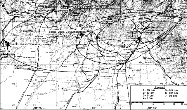 |
Figure 8. Isopach map of airfall deposits from activity on 27-31 July 1991 at Pacaya. Base Map is a portion of Guatemala 1:250,000 sheet (ND 15-8, Dirección General de Cartografía, Guatemala City, Guatemala). Contour interval, 100 m. Courtesy of E. Sánchez. |
"During the last eruption, on 1 August, INSIVUMEH recommended to emergency agencies that the approximately 1,500 residents of Caracol, Rodeo, and Patrocinio be evacuated, due to the hazard of a new violent eruption. The next day, seismic and eruptive activity decreased considerably, allowing the evacuated people to return home. Activity continued to decrease quickly, with 40 B-type microearthquakes (frequency, 4-5 Hz, and amplitude, 2.0-2.5 mm) recorded daily on 7 August. Activity as of 15 August was considered at low levels."
Geological Summary. Eruptions from Pacaya are frequently visible from Guatemala City, the nation's capital. This complex basaltic volcano was constructed just outside the southern topographic rim of the 14 x 16 km Pleistocene Amatitlán caldera. A cluster of dacitic lava domes occupies the southern caldera floor. The post-caldera Pacaya massif includes the older Pacaya Viejo and Cerro Grande stratovolcanoes and the currently active Mackenney stratovolcano. Collapse of Pacaya Viejo between 600 and 1,500 years ago produced a debris-avalanche deposit that extends 25 km onto the Pacific coastal plain and left an arcuate scarp inside which the modern Pacaya volcano (Mackenney cone) grew. The NW-flank Cerro Chino crater was last active in the 19th century. During the past several decades, activity has consisted of frequent Strombolian eruptions with intermittent lava flow extrusion that has partially filled in the caldera moat and covered the flanks of Mackenney cone, punctuated by occasional larger explosive eruptions that partially destroy the summit.
Information Contacts: E. Sánchez, INSIVUMEH; Philippe Rocher, L.A.V.E., France; ACAN network, Panama City, Panama.