Report on Galeras (Colombia) — July 1991

Bulletin of the Global Volcanism Network, vol. 16, no. 7 (July 1991)
Managing Editor: Lindsay McClelland.
Galeras (Colombia) More small explosions; increased seismicity and deformation
Please cite this report as:
Global Volcanism Program, 1991. Report on Galeras (Colombia) (McClelland, L., ed.). Bulletin of the Global Volcanism Network, 16:7. Smithsonian Institution. https://doi.org/10.5479/si.GVP.BGVN199107-351080
Galeras
Colombia
1.22°N, 77.37°W; summit elev. 4276 m
All times are local (unless otherwise noted)
Seismicity and emissions began to increase at the end of July, leading to the evacuation of 11 people working on the summit . . . in early August. Released seismic energy (see figure 52) and reduced displacement (figure 42) of long-period earthquakes reached the highest values since the start of monitoring in February 1989. Amplitudes and durations for long-period events showed slow increases, as well. Tremor was recorded in low-frequency bands and modulated packs, with small variations in amplitude and period.
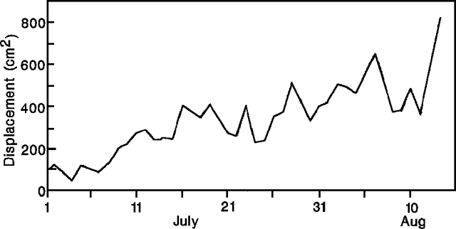 |
Figure 42. Daily reduced displacement of long-period earthquakes at Galeras, July-August 1991. Courtesy of INGEOMINAS. |
Long-period events, shallow in origin and often associated with gas-and-ash emissions, increased to >100/day by mid-August. The number of gas-and-ash emissions increased correspondingly. Plume heights reached 2 km and ash was deposited to 8 km N and NW. Head-sized blocks, hot to the touch, were periodically ejected onto the crater rim.
Inflation, continuing since September 1990, increased dramatically during the first half of August, when 265.8 µrad tangential and -180.6 µrad radial deformation were measured (figure 43) 0.9 km E of the crater ("Crater" electronic tiltmeter). The resultant inflation vector was 321.35 µrad with an azimuth of 115.81°.
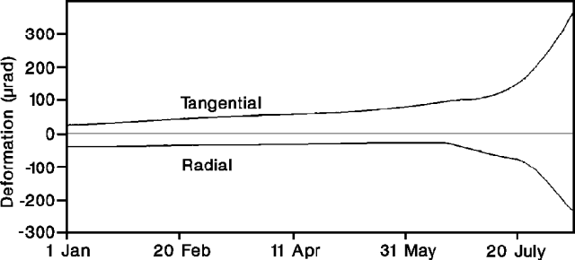 |
Figure 43. Tangential (top curve) and radial (bottom curve) deformation at the Crater electronic tiltmeter at Galeras, January-August 1991. Courtesy of INGEOMINAS. |
Geological Summary. Galeras, a stratovolcano with a large breached caldera located immediately west of the city of Pasto, is one of Colombia's most frequently active volcanoes. The dominantly andesitic complex has been active for more than 1 million years, and two major caldera collapse eruptions took place during the late Pleistocene. Long-term extensive hydrothermal alteration has contributed to large-scale edifice collapse on at least three occasions, producing debris avalanches that swept to the west and left a large open caldera inside which the modern cone has been constructed. Major explosive eruptions since the mid-Holocene have produced widespread tephra deposits and pyroclastic flows that swept all but the southern flanks. A central cone slightly lower than the caldera rim has been the site of numerous small-to-moderate eruptions since the time of the Spanish conquistadors.
Information Contacts: INGEOMINAS-OVP; S. Williams and M. Calvache, Arizona State Univ.