Report on Karthala (Comoros) — August 1991

Bulletin of the Global Volcanism Network, vol. 16, no. 8 (August 1991)
Managing Editor: Lindsay McClelland.
Karthala (Comoros) Details of seismicity and deformation associated with the 11 July eruption
Please cite this report as:
Global Volcanism Program, 1991. Report on Karthala (Comoros) (McClelland, L., ed.). Bulletin of the Global Volcanism Network, 16:8. Smithsonian Institution. https://doi.org/10.5479/si.GVP.BGVN199108-233010
Karthala
Comoros
11.75°S, 43.38°E; summit elev. 2361 m
All times are local (unless otherwise noted)
The bottom of the summit's Choungou-Chahalé crater, obscured by a cloud of white gas and vapor following the 11 July phreatic eruption, became visible in early August. A new explosion crater (~250 m in diameter) was observed in its SE section. Vigorous degassing occurred through the crater lake and from the wall of the new crater. The following, from Patrick Bachélery, supplements the report in 16:6.
Karthala's 11 July explosion followed an increase in seismicity from 3-5 events/month (June 1988 start of monitoring through early April 1991) to 3-10 events/day in May (figure 2). Earthquakes were centered beneath the crater, mostly at 0-2 km below sea level, with a few 10-20 km below sea level. On 4 May, a swarm of 161 earthquakes (M 0.5-2) was recorded during a 1-hour period beginning at 1609. The number of earthquakes increased to 30-50/day by the end of June, and all were at shallow depths. Deformation measurements showed summit inflation of ~20 µrad during this time; only weak changes in deformation had been measured between the network's installation (May 1987) and June 1989.
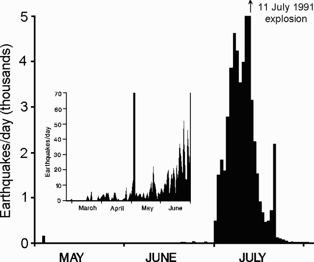 |
Figure 2. Daily number of earthquakes at Karthala, March-June (inset) and May-July 1991. Courtesy of P. Bachélery. |
A notable change in seismicity occurred on 30 June at 1645. More than 500 earthquakes (long- and short-period) were recorded that day, as many on the next, and >1,500 daily 2-4 July (figure 2). The short-period events (M 0.5-3.1) were centered in a roughly N-S line below the S part of the summit caldera and the S flank of the volcano (figure 3). Felt shocks caused ~1,000 people to leave the lower part of the S flank.
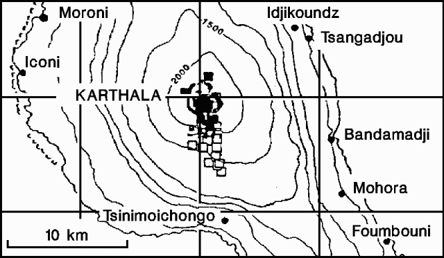 |
Figure 3. Epicenter map of short-period earthquakes at Karthala during 30 June-4 July (open squares) and 5-10 July 1991 (filled squares). Courtesy of P. Bachélery. |
Seismicity continued to increase from 4 July, with 4,000 earthquakes recorded daily by 10 July. A swarm of nearly continuous seismic events was recorded between 0040 and 0110 the next day. The 4-10 July seismicity was characterized by low-magnitude (mostly M <1, sometimes to M 3.4) short-period events located under the summit at 1-4 km depths, and less numerous deeper earthquakes at 4-8 km depth. Some long-period events with cigar-shaped waveform envelopes were also recorded. The center of seismicity shifted N, resulting in fewer felt shocks in the S part of the island, while several M 3 earthquakes were felt in Moroni (13 km NW of the crater).
Deformation measurements (dry-tilt) the morning of 10 July showed >120 µrad of inflation centered on Choungou-Chahalé and Choungou-Chagnoumeni (figure 4) craters since 28 June. That night, the eruption took place, but no eyewitness accounts are available. Seismicity reached its highest intensity during an 11-hour period that night [but see 16:6], dropping abruptly at 0335 on 11 July to ~100 recorded events/hour. About 1.5 hours later, a strong sulfur odor was detected in Moroni for ~2 hours.
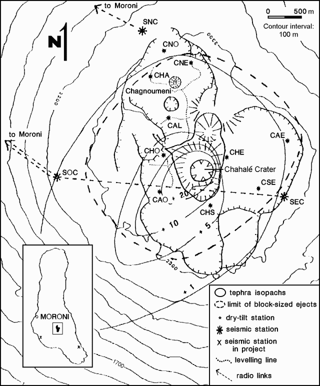 |
Figure 4. Map showing Karthala's summit region and deposits from the 11 July 1991 explosion. Courtesy of P. Bachélery. |
Later visits to the summit revealed that a sizeable phreatic explosion had occurred in Choungou-Chahalé crater. The southern 2/3 of the summit caldera were covered by blocks (up to 10 m3) and ash (figure 4), and the summit vegetation was completely removed from within the limits of the caldera. The crater bottom was hidden by gas and vapor clouds, obscuring the source of a "fountaining" sound heard two weeks after the 11 July explosion. Geologists later believed the sound to have been caused by the forceful arrival of water into the new crater, forming the crater lake.
Seismicity rapidly decreased after the explosion, although several earthquakes of M 3.0-3.5 were recorded through the end of July. In August, 20-40 events/day were recorded, the same level as in June.
Geological Summary. The southernmost and largest of the two shield volcanoes forming Grand Comore Island (also known as Ngazidja Island), Karthala contains a 3 x 4 km summit caldera generated by repeated collapse. Elongated rift zones extend to the NNW and SE from the summit of the Hawaiian-style basaltic shield, which has an asymmetrical profile that is steeper to the S. The lower SE rift zone forms the Massif du Badjini, a peninsula at the SE tip of the island. Historical eruptions have modified the morphology of the compound, irregular summit caldera. More than twenty eruptions have been recorded since the 19th century from the summit caldera and vents on the N and S flanks. Many lava flows have reached the sea on both sides of the island. An 1860 lava flow from the summit caldera traveled ~13 km to the NW, reaching the W coast to the N of the capital city of Moroni.
Information Contacts: P. Bachélery, Univ de la Réunion; D. Ben Ali and J-L. Klein, CNDRS, RFI des Comores; F. Desgrolard, Centre de Recherche Volcanologique, Clermont-Ferrand, France; J-L. Cheminée, J-P. Toutain, and J-C. Delmond, IPGP.