Report on Cerro Hudson (Chile) — August 1991
Bulletin of the Global Volcanism Network, vol. 16, no. 8 (August 1991)
Managing Editor: Lindsay McClelland.
Cerro Hudson (Chile) Basaltic fissure eruption preceded andesitic paroxysmal phase; strong winds rework major ash deposits
Please cite this report as:
Global Volcanism Program, 1991. Report on Cerro Hudson (Chile) (McClelland, L., ed.). Bulletin of the Global Volcanism Network, 16:8. Smithsonian Institution. https://doi.org/10.5479/si.GVP.BGVN199108-358057
Cerro Hudson
Chile
45.9°S, 72.97°W; summit elev. 1905 m
All times are local (unless otherwise noted)
In one of the largest eruptions of the century, Hudson's mid-August paroxysm produced an eruption cloud 18 km high and deposited ash up to 1,000 km SE. Estimates of tephra volume range between 2 and 6 km3; >1 km3 was deposited in Chile, around 2 km3 in Argentina, and 2 km3 may have fallen in the Atlantic Ocean or been lost to the atmosphere. Satellite data showed that the eruption produced a large SO2-rich cloud, estimated to contain 1.5 megatons of SO2 on 16 August, that was transported twice around the globe in 2 weeks.
The following is from a report by Norman Banks. "The eruption produced 1 to 2+ km3 (dense rock equivalent) of magma. The initial 8-9 August eruption (beginning about 1820 on 8 August) was from a basaltic (50% SiO2) dike through a fissure 4 km long, trending through the NW rim of the 10 x 7 km, ice-filled caldera. The basalt erupted both as a lava fountain and phreatomagmatically, producing a tephra column 12 km high, scoria flows that covered 10 km2 of the western caldera floor and an unknown area outside of the caldera, a 4-km-long lava flow over the WNW flank's Huemules glacier, long-lived (12 hours) floods down the Río Sorpresa (WSW flank) and Río Huemules valleys, and a rather low-volume tephra-fall deposit N of the volcano. This ash had a moderate level (100-300 ppm dry weight) of soluble fluorine that was quickly reduced to 2-10 ppm by heavy rains during the next 2 weeks. Grass growing through this deposit has a fluorine content of about 30 ppm.
"The andesitic eruption of 12-15 August may have been due to secondary boiling triggered by intrusion of the 8 August basalt, or other basaltic dikes into the andesitic magma body under the caldera; bombs and lapilli of pumiceous andesite (60% SiO2) mixed with chilled basalt are common in the tephra-fall deposits. The 3-day andesitic eruption produced a strong Plinian column that ejected pyroclastic material into a very strong SE-directed stratospheric wind (185 km/hr) that kept the plume narrow even 700 km from the volcano. Pumiceous ballistic bombs 1 m in diameter were found 10 km from the vent, where tephra-fall deposits were >2.5 m thick. The 10-cm isopach reached just SE of Chile Chico (120 km SE of the vent) and 1-2 cm of ash was deposited at Argentina's coast (figure 5). [As many as 13 distinct layers of ash were deposited in some locations.] Fortunately, pyroclastic flows did not spill onto the outer snow-covered flanks during this episode, and no additional mudflows were reported. Shortly after the 12-15 August eruption, however, secondary water-and-pumice flows formed on the volcano's flanks during daily melting of the snow. Because most of the thick deposits on the steep mountainous terrain SE of the volcano are on and interleaved with snow, downslope movement and associated hydrological problems for the downstream valleys are certain to accelerate as the summer melting and rains begin. The andesitic ash in Chile had low amounts of soluble fluorine (<20 ppm), and grass covered by or growing through the ash deposits has a relatively low fluorine content. Analysis of fine fractions of the Chilean deposits suggest that downwind (Argentinean) fluorine values will not be significantly higher."
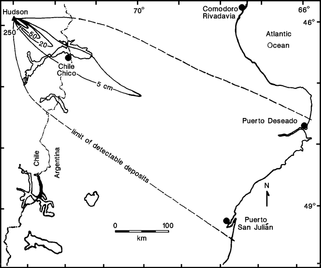 |
Figure 5. Preliminary isopach map of the 12-15 August 1991 tephra-fall deposits from Hudson. Prepared by N. Banks, H. Moreno, H. Corbella, M. Haller, and H. Ostera. |
Steam emission, occasionally containing minor quantities of ash, declined rapidly following the eruption's end on 15 August.
Major reworking of ash deposits in Argentina by strong winds led to several false reports of renewed activity at Hudson. Ash was redistributed N to Comodoro Rivadavia (2 mm at 400 km E of Hudson) and was reported S to Río Gallegos (700 km SSE). In early September, GOES satellite images detected ash clouds, probably below 3 km, carried by ground-level winds at 55-65 km/hr; these clouds extended from near the volcano to over the Atlantic ocean. The densest part of the clouds appeared to be ~250 km SE of the volcano, about halfway to the Argentine coast. Poor visibility, down to a few hundred meters, was reported at Puerto Deseado and Puerto San Julián. Argentine officials have expressed concern over the >2 million sheep and 3,000 cattle in the affected region.
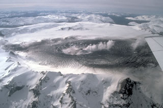
Geological Summary. The ice-filled, 10-km-wide caldera of Cerro Hudson volcano was not recognized until its first 20th-century eruption in 1971. It is the southernmost volcano in the Chilean Andes, related to subduction of the Nazca plate beneath the South American plate. The massive volcano covers an area of 300 km2. The compound caldera is drained through a breach on its NW rim, which has been the source of mudflows down the Río de Los Huemeles. Two cinder cones occur N of the volcano and others occupy the SW and SE flanks. This volcano has been the source of several major Holocene explosive eruptions. An eruption about 6,700 years ago was one of the largest known in the southern Andes during the Holocene; another eruption about 3,600 years ago also produced more than 10 km3 of tephra. An eruption in 1991 formed a new 800-m-wide crater in the SW portion of the caldera.
Information Contacts: N. Banks, USGS; H. Moreno, Univ de Chile; J. Naranjo, SERNAGEOMIN; P. Bitschene, Patagonia Volcanism Program, Argentina; P. Maxwell, US Embassy, Buenos Aires; D. Helms, Lockheed, Houston; S. Doiron and G. Bluth, GSFC.