Report on Pinatubo (Philippines) — September 1991

Bulletin of the Global Volcanism Network, vol. 16, no. 9 (September 1991)
Managing Editor: Lindsay McClelland.
Pinatubo (Philippines) Small secondary explosions from pyroclastic-flow deposits; fewer mudflows with less rain
Please cite this report as:
Global Volcanism Program, 1991. Report on Pinatubo (Philippines) (McClelland, L., ed.). Bulletin of the Global Volcanism Network, 16:9. Smithsonian Institution. https://doi.org/10.5479/si.GVP.BGVN199109-273083
Pinatubo
Philippines
15.13°N, 120.35°E; summit elev. 1486 m
All times are local (unless otherwise noted)
Although no explosions have occurred in the caldera since 2 September (16:8), small secondary explosions continued through early October, at pyroclastic-flow deposits from the paroxysmal June eruption. Seismicity was at low levels, and a decrease in the number of mudflows reflected decreased rainfall.
16-22 September. Several secondary explosions were observed at pyroclastic-flow deposits in the Sacobia valley (NE flank). Ash was periodically reported falling at Clark Air Base (20 km E) and Angeles (25 km E), with 5 mm deposited on the morning of 18 September. No steam or ash emissions were recorded from the summit caldera.
Clusters of high-frequency earthquakes persisted near the caldera (figure 22), but noticeably fewer events have been recorded since June, especially at shallow depths (figure 23). A slight increase in seismicity was associated with a M 4.5 earthquake at 0151 on 17 September. The shock was felt at intensity V (modified Rossi-Forel scale) at Clark Air Base, with aftershocks of intensities I-IV. Occasional low-frequency, small-amplitude harmonic tremor of uncertain origin was recorded 21-22 September. Explosion-type low-frequency signals were periodically observed during and after heavy rainfall.
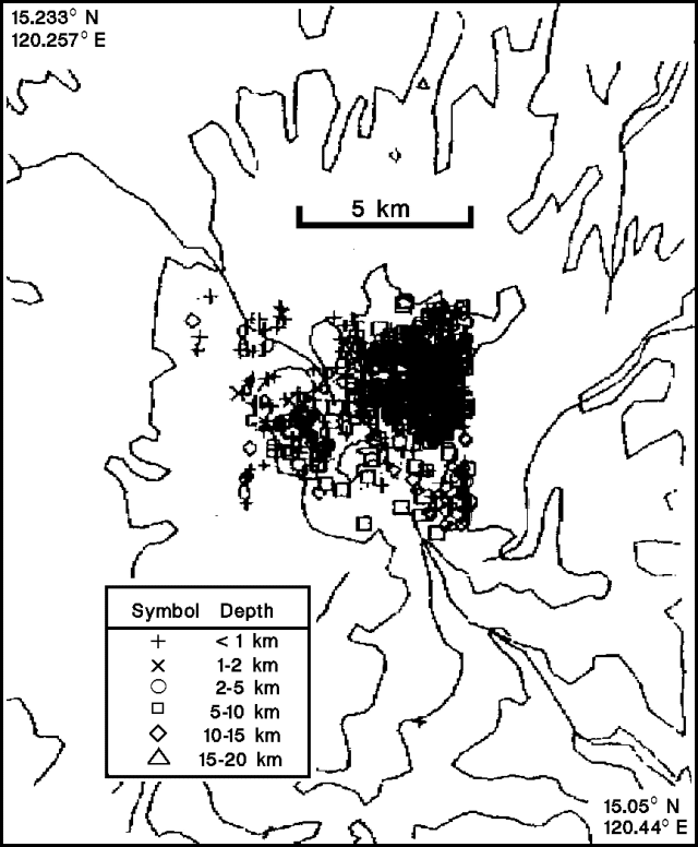 |
Figure 22. Epicenters of 619 earthquakes recorded near Pinatubo, 27 May-22 September 1991; 515 had magnitudes less than 1, 104 were of M 1-2. Contours are diagrammatic. Courtesy of PHIVOLCS. |
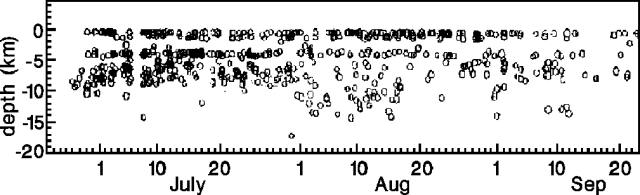 |
Figure 23. Depths of 619 earthquakes at Pinatubo, 27 June-22 September 1991. Courtesy of PHIVOLCS. |
A lake that had formed in the Mapanuepe River (SW flank), following damming by pyroclastic-flow deposits, continued to grow until heavy rain caused it to overflow on 21 September. The dam was quickly incised and partially breached, leading to flooding in San Narciso (~35 km SW) on 22 September.
23-29 September. No ashfall occurred at Clark Air Base, although several secondary explosions were observed. The number of high-frequency earthquakes (M < 3.6) decreased slightly from the previous week. Three shocks were felt (intensity I-II) on 28 September. Minimal rains occurred during the week, and no mudflows were detected. The caldera lake was turquoise-blue and steamed along its S wall during a 23 September helicopter overflight. Fresh landslides were noted on the steep-sided caldera walls.
30 September-6 October. Secondary explosions produced plumes to 4,500 m high, and ash fell on Angeles 3 October. SO2 flux from the caldera, measured by COSPEC, was only 18 t/d. Geologists noted that this flux represented SO2 rising from the caldera lake, and subaerial fumaroles; an unknown quantity of SO2 from fumaroles below the lake may be going into solution. The lake had a temperature of 40°C and a pH of 6.0 on 8 October.
Investigations of hydrologic changes caused by the thick pyroclastic-flow deposits and voluminous debris-flow deposits were not yet able to resolve whether the Abacan River (E flank) would be captured by the Sacobia River. Numerous catchment basins and dams were under construction in an attempt to constrain the Abacan River.
High-frequency seismicity decreased slightly, with a daily average of 63 recorded earthquakes, compared to 71 the preceding week. Events were centered at 2-10 km depths, shallower than the preceding week (5-15 km depths), and were distinctly clustered E of the caldera. Most of the earthquakes had magnitudes less than 2, although some reached M 3, and many were felt at Clark Air Base. Two mudflows were detected during the week.
Casualties and damages. The United Nations Development Programme reported on 15 October that the human death toll had reached 722. Of these, 358 deaths were attributed to disease, 281 to the initial eruption, and 83 to mudflows. An additional 184 people were injured, and 23 reported missing. More than 108,000 houses were partially or totally damaged, more than 100,000 people were still being fed at 143 evacuation centers, and an additional 70,000 were being fed near affected villages.
Geological Summary. Prior to 1991 Pinatubo volcano was a relatively unknown, heavily forested lava dome complex located 100 km NW of Manila with no records of historical eruptions. The 1991 eruption, one of the world's largest of the 20th century, ejected massive amounts of tephra and produced voluminous pyroclastic flows, forming a small, 2.5-km-wide summit caldera whose floor is now covered by a lake. Caldera formation lowered the height of the summit by more than 300 m. Although the eruption caused hundreds of fatalities and major damage with severe social and economic impact, successful monitoring efforts greatly reduced the number of fatalities. Widespread lahars that redistributed products of the 1991 eruption have continued to cause severe disruption. Previous major eruptive periods, interrupted by lengthy quiescent periods, have produced pyroclastic flows and lahars that were even more extensive than in 1991.
Information Contacts: R. Punongbayan, PHIVOLCS; J. Tomblin, UN Disaster Relief Organization, Switzerland.