Report on Unzendake (Japan) — September 1991
Bulletin of the Global Volcanism Network, vol. 16, no. 9 (September 1991)
Managing Editor: Lindsay McClelland.
Unzendake (Japan) Dome collapse triggers large pyroclastic flow, then new dome extruded
Please cite this report as:
Global Volcanism Program, 1991. Report on Unzendake (Japan) (McClelland, L., ed.). Bulletin of the Global Volcanism Network, 16:9. Smithsonian Institution. https://doi.org/10.5479/si.GVP.BGVN199109-282100
Unzendake
Japan
32.761°N, 130.299°E; summit elev. 1483 m
All times are local (unless otherwise noted)
Lava dome growth continued in Jigoku-ato crater through early October, generating frequent pyroclastic flows by partial dome collapse. A seismic swarm began beneath the crater on 6 September, peaking 7-9 September and again on 15-16 September. Seismicity was similar to that of mid-August when dome 3 (formerly called the central dome, or C-dome) began to grow, although September activity was more vigorous.
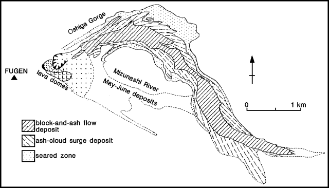
Extruded lava pushed the crater wall NE, leading to a collapse of the crater wall and the adjoining dome 3 at 1854 on 15 September. Red-colored ash plumes were observed intermittently earlier in the day, becoming stronger and more frequent by the start of a 2-hour increase in the number and size of pyroclastic flows at 1644. The activity culminated in a major pyroclastic flow that generated an 11-minute seismic signal, the longest since 8 June, composed of 6 successive events including one that lasted 4 minutes beginning at 1857. The pyroclastic flow traveled ENE down the Oshiga Valley, then followed it SE into the Mizunashi River valley, reaching 5.5 km from the dome (figure 33), the same distance as the 8 June flow. An ash cloud surge detached from the flow at the confluence of the Oshiga with the Mizunashi River, continuing SE into the Onokoba area of Fukae city. A car previously burned by June pyroclastic flows was thrown about 60 m by the surge. Although it appeared that the surge rapidly lost force when it detached from the rest of the pyroclastic flow, its temperature remained high. [A total of 218] houses were burned, but the area had already been evacuated and there were no injuries.
 |
Figure 33. Map showing the distribution of the 15 September 1991 pyroclastic-flow deposits at Unzen. Courtesy of Setsuya Nakada. |
The average speed of the pyroclastic flow was estimated at 95 km/hour, using the interval between the start of the flow's seismic signal and its cessation when the flow destroyed the telemeter cable. The volume of collapsed dome lavas and pre-existing summit rock was estimated to be 3.5 x 10⁶ m3, of which 2.5 x 10⁶ m3 was believed to be from the dome. Using aerial photos, the Ministry of Construction estimated the volume of 15 September pyroclastic-flow deposits at 4 x 10⁶ m3, indicating that the main flow was the largest since the start of activity in May. Flow deposits were about 5 m thick, and although the interior was still hot 3 weeks after deposition, no gas-pipe structures were observed. Lava blocks in the deposits were massive, without the breadcrust or cauliflower surfaces seen in the 8 June pyroclastic-flow deposits. The biotite hornblende dacite composition of the blocks was the same as that of lava fragments from the 3 and 8 June flows and the pumice ejected from Jigoku-ato crater on 11 June. Peripheral surge deposits consisted of a lower coarse sand layer, and an upper reddish ash layer.
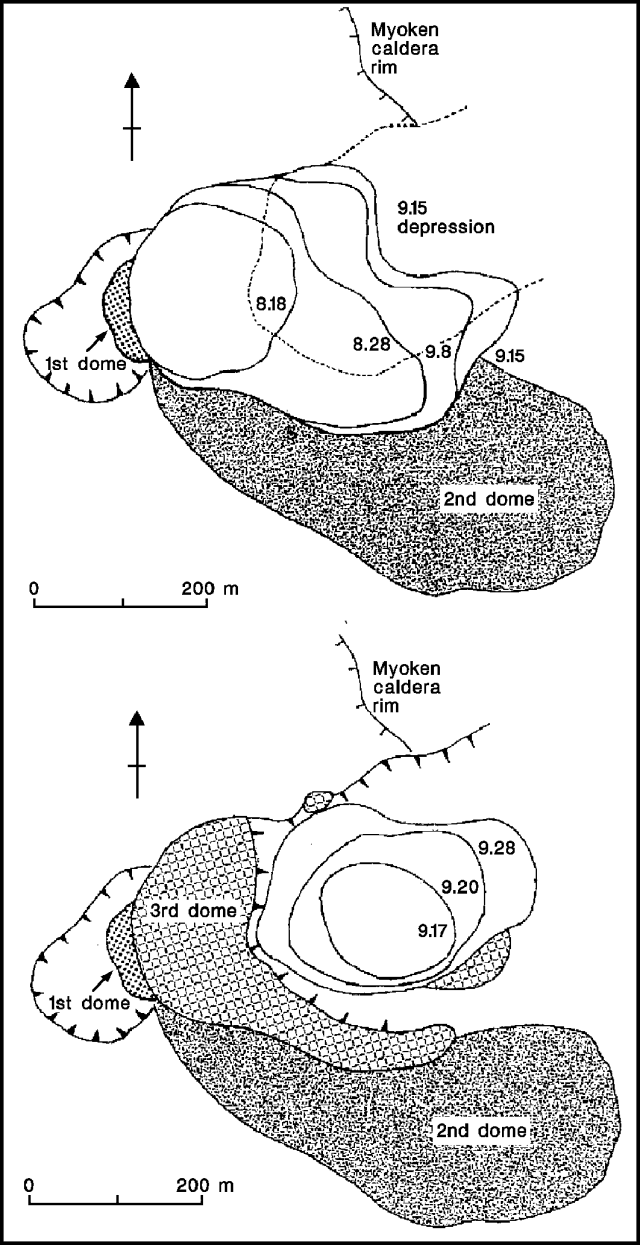
A total of 448 earthquakes was recorded on 16 September, the most in one day since July 1990, but seismicity rapidly declined, reaching former levels by the following morning. Dome 4 began to grow in the horseshoe-shaped depression (about 300 m wide and 400 m long) formed by the collapse of dome 3 (figure 34). By 20 September, it had grown to about 1.6 x 10⁶ m3, indicating an extrusion rate of about 3.5 x 10⁵ m3/day. The new dome was 350 m long, 250 m wide, and >150 m high on 10 October. Following the pattern of dome 2, the length of dome 4 stopped increasing at the end of September, as continuing collapse of its distal end generated small-scale block-and-ash flows. The upper reaches of the Oshiga valley were filled with debris shed from the domes, and large pyroclastic flows were rare.
A total of 521 seismically determined pyroclastic-flow events and 2102 earthquakes were recorded in September, increases from 292 and 559, respectively, in August. There were no felt shocks in either September or early October.
Geological Summary. The massive Unzendake volcanic complex comprises much of the Shimabara Peninsula east of the city of Nagasaki. An E-W graben, 30-40 km long, extends across the peninsula. Three large stratovolcanoes with complex structures, Kinugasa on the north, Fugen-dake at the east-center, and Kusenbu on the south, form topographic highs on the broad peninsula. Fugendake and Mayuyama volcanoes in the east-central portion of the andesitic-to-dacitic volcanic complex have been active during the Holocene. The Mayuyama lava dome complex, located along the eastern coast west of Shimabara City, formed about 4000 years ago and was the source of a devastating 1792 CE debris avalanche and tsunami. Historical eruptive activity has been restricted to the summit and flanks of Fugendake. The latest activity during 1990-95 formed a lava dome at the summit, accompanied by pyroclastic flows that caused fatalities and damaged populated areas near Shimabara City.
Information Contacts: JMA; S. Nakada, Kyushu Univ.


