Report on Pinatubo (Philippines) — October 1991

Bulletin of the Global Volcanism Network, vol. 16, no. 10 (October 1991)
Managing Editor: Lindsay McClelland.
Pinatubo (Philippines) Continued secondary explosions and mudflows; seismicity declines; fieldwork in new caldera
Please cite this report as:
Global Volcanism Program, 1991. Report on Pinatubo (Philippines) (McClelland, L., ed.). Bulletin of the Global Volcanism Network, 16:10. Smithsonian Institution. https://doi.org/10.5479/si.GVP.BGVN199110-273083
Pinatubo
Philippines
15.13°N, 120.35°E; summit elev. 1486 m
All times are local (unless otherwise noted)
Although no explosions occurred within the caldera formed by the mid-June paroxysmal eruption, secondary explosions continued at pyroclastic-flow deposits through early November, causing ashfall, sulfur odors, and poor visibility. Seismicity and caldera steam emission continued to decline. Debris flows traveled down all major drainages during October, but observations suggested that the majority of the flows were more water-rich than in previous months.
7-13 October. Geologists entered the caldera for the first time on 8 October. The caldera rim elevation ranges from 1,100 m to about 1,000 m, with the lowest point on the NW side, and the caldera lake at roughly 800 m elevation. Strong steaming was observed on the S wall and along the lake shore, with numerous bubbles rising elsewhere in the lake. No ambient sulfur odor was detected when standing upwind of the fumaroles. Analyses of the caldera lake water revealed a temperature of 40°C and a pH of 6 (table 6), suggesting a primarily meteoric origin, although the plume's SO2 flux dropped from roughly 100 t/d to 10 t/d when the lake formed. Most of the 1991 deposits within the caldera are composed of old dome rock, with almost no pumice present. No distinct ring faults are apparent.
Table 6. Chemistry of Pinatubo caldera lake water, 8 October 1991. Analyses by M. Campita, L. Ringer, and L. Tansinsin, PHIVOLCS.
| Data Element | Value |
| Temperature | 40°C |
| pH | 6.01 |
| Na | 211 ppm |
| Ca | 481 ppm |
| K | 63.7 ppm |
| Cl | 1049.2 ppm |
| F | < 0.1 ppm |
| B | 39.6 ppm |
| H2S | 251.6 ppm |
| SO2 | 294.4 ppm |
| SO4 | 1431.13 ppm |
| Mg | 382.81 ppm |
| SiO2 | 54 ppm |
| Total acidity | 80 ppm |
| Mineral acid | 0 acidity |
| Total Dissolved Solids | 5133 |
Several small secondary explosions from the Sacobia valley pyroclastic-flow deposits (NE flank) were observed on 13 October; the largest, at 1247, produced a plume 2,000 m high. By about 1400, a sulfurous odor was detected, and moderate ashfall occurred at Clark Air Base. Secondary explosion signals were recorded seismically on 7 and 8 October but were not visually confirmed, while at other times during the week, small explosions were observed but not seismically recorded.
Seismicity continued to decline, with an average of 55 earthquakes recorded daily, compared to 63/day the previous week (figure 24). The earthquakes occurred at 2-10 km depth and most had magnitudes < 2. Two shocks of intensity I (modified Rossi-Forel scale) were felt at Clark Air Base.
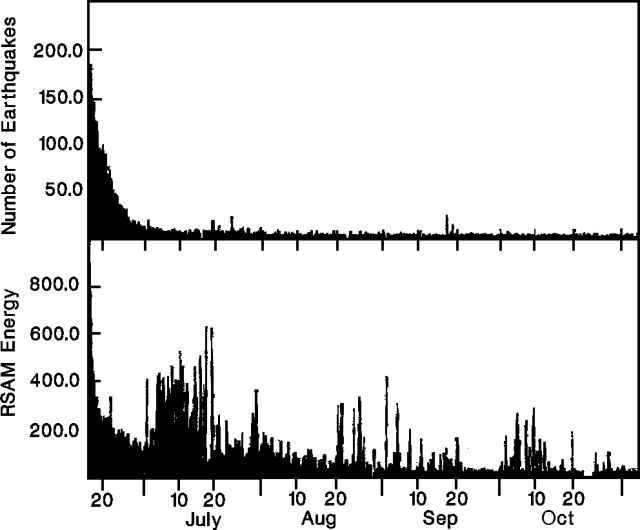 |
Figure 24. Number of earthquakes (top) and Real-time Seismic Amplitude Measurement (bottom) at Pinatubo, 16 June-3 November 1991. Courtesy of PHIVOLCS. |
Relatively small debris flows occurred in the NE, SE, and SW quadrants following heavy rainfall. Residents of Tarlac (45 km NE) noted that no large lahars had passed in the previous several weeks to months. Floods were reported along the E flank's Pasig-Potrero River (2/3 m deep) on 7 October, and the NE flank's Bamban River (waist-chest deep). Small flows occurred on the Pasig-Potrero River on 12 October, and the Sacobia, Abacan (both NE flank), and Pasig-Potrero Rivers on 13 October. The debris dam on the SE flank's Mapanuepe River began breaching again on 12 October.
14-20 October. Secondary explosions occurred in the upper Marella pyroclastic-flow deposits (SW flank) around midmorning on 14 October. One hour later, ashfall, accompanied by a sulfur odor and reduced visibility (500 m), were reported at Sitio Danalaon (18 km SW of the summit). By 1600, ash fell in Castillejos and San Marcelino (both ~30 km SW of the summit), and by 1800, ash fell in Subic (~35 km SSW). Additional explosions occurred in the upper Marella deposits on 16 and 18 October when a 500-m grayish ash cloud was produced. Ashfall from other secondary explosions was also reported in Angeles (25 km E) on 15 October.
Seismicity during the week declined to a daily average of 44 earthquakes, with most events at 5-10 km depths and M < 2. Earthquakes continued to occur in clusters. One large shock (M 3.4) on 15 October, centered about 4 km NE of the summit, was felt (intensity IV) at Clark Air Base. Other earthquakes were felt (intensities I-II) on 15, 16, 18, and 20 October.
Heavy rains on 16 October triggered small lahars on the NE, SW, and SE flanks. One large lahar, about 3 m high, traveled down the upper Pasig-Potrero River, transporting boulders up to 1 m in diameter. Small floods of muddy water were observed on the Marella River on the 14th.
21 October-3 November. An aerial survey of the caldera on 23 October showed that the lake level had risen, covering some large rocks that had been visible in August and September. Steam emissions on the S wall had decreased, and some had stopped. Some fresh talus extended into the lake. Observers 20 km SW (at Sitio Danalaon) reported pulsating weak to moderate steam emission from the caldera on 2 November.
Moderate-sized secondary explosions occurred in the Sacobia and Marella valley pyroclastic-flow deposits on 28 October, coincident with heavy rainfall. Near the Sacobia valley, sand-sized ashfall from secondary explosions was quite heavy during the early evening, and poor visibility caused drivers to stop their vehicles. Smaller explosions were observed in the Sacobia valley on 22 and 31 October, and in the Marella valley on 2 November when a dirty cloud 200 m high was produced.
The number of earthquakes averaged 37/day, at 5-10 km depths and mostly M < 2. The earthquakes occurred in clusters E, SSE, SW, N, and NW of the caldera (figure 25). Four shocks were felt at Clark Air Base, the largest (M 3.4) with intensity IV on 1 November, the other three (M 2.9-3.0, intensity I) on 25 and 31 October and 3 November.
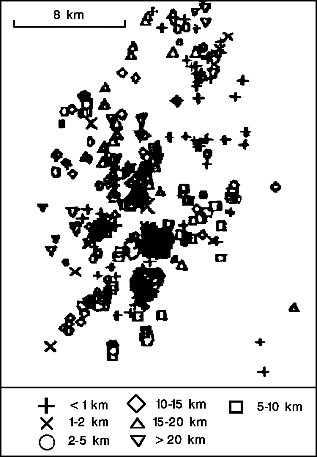 |
Figure 25. Epicenters of 515 earthquakes at Pinatubo, 21 October-3 November 1991. Courtesy of PHIVOLCS. |
Heavy rain from typhoon Ruth triggered lahars down most drainages on 28 October. On the SW flank, following 8 cm of rain in a 24-hour period, a hot lahar was observed travelling down the Marella River, a lahar up to 1 m high was observed on the Sto. Tomas River, and the debris dam on the Mapanuepe River was completely swept away. Lahars on the Pasig-Potrero River grew from ~0.5 m high at 1400, to a peak of 3 m high at 1654, and carried .5m-diameter pumice clasts and logs 3 m long and 30 cm in diameter. A lahar >1 m high was reported on the Porac River and a 65 cm hyperconcentrated flow was reported on the Gumain River (both SE flank). On the NE flank, lahars were reported on the Abacan and O'Donnell Rivers, and reached 3 m high on the Sacobia River. Flows were reported NW of the volcano, but they were more water-rich than previously, and there was no significant deposition. Small lahars occurred for several days following the 28th.
Geological Summary. Prior to 1991 Pinatubo volcano was a relatively unknown, heavily forested lava dome complex located 100 km NW of Manila with no records of historical eruptions. The 1991 eruption, one of the world's largest of the 20th century, ejected massive amounts of tephra and produced voluminous pyroclastic flows, forming a small, 2.5-km-wide summit caldera whose floor is now covered by a lake. Caldera formation lowered the height of the summit by more than 300 m. Although the eruption caused hundreds of fatalities and major damage with severe social and economic impact, successful monitoring efforts greatly reduced the number of fatalities. Widespread lahars that redistributed products of the 1991 eruption have continued to cause severe disruption. Previous major eruptive periods, interrupted by lengthy quiescent periods, have produced pyroclastic flows and lahars that were even more extensive than in 1991.
Information Contacts: R. Punongbayan, PHIVOLCS.