Report on Cerro Hudson (Chile) — November 1991
Bulletin of the Global Volcanism Network, vol. 16, no. 11 (November 1991)
Managing Editor: Lindsay McClelland.
Cerro Hudson (Chile) Large plumes on satellite images, probably wind-blown August tephra
Please cite this report as:
Global Volcanism Program, 1991. Report on Cerro Hudson (Chile) (McClelland, L., ed.). Bulletin of the Global Volcanism Network, 16:11. Smithsonian Institution. https://doi.org/10.5479/si.GVP.BGVN199111-358057
Cerro Hudson
Chile
45.9°S, 72.97°W; summit elev. 1905 m
All times are local (unless otherwise noted)
Satellite images on 27 November revealed extensive gray plumes extending from the vicinity of Hudson more than 1,000 km across southern Argentina and the western Atlantic Ocean (figure 7). The next day, ash could be tracked over the Atlantic to beyond 40°W. Additional, smaller plumes were seen on 3 December satellite images. Although the plumes appeared to have been generated by new eruptive activity, observers near the volcano saw no tephra ejection and seismic instruments detected no change from background seismicity. These ash clouds were probably generated as strong winds remobilized fine ash from the August eruption. The press reported heavy ashfall at Mar del Plata, on Argentina's Atlantic coast >1,500 km NE of Hudson, on 2-3 December. All flights from nearby Camet airport were cancelled because of reduced visibility and mounds of ash blocking runways.
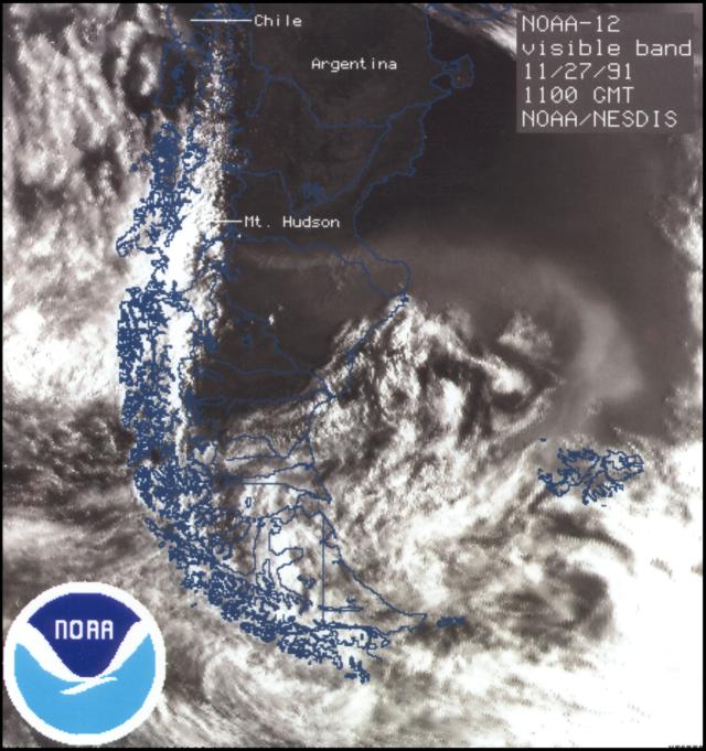 |
Figure 7. Visible-band image from the NOAA-12 polar-orbiting weather satellite on 27 November at 0800, showing an ash plume extending from the vicinity of Hudson to the western Atlantic Ocean. Courtesy of G. Stephens. |
High winds and limited post-eruption rainfall may combine to make Hudson's ash deposits particularly mobile. During a flight into a town (Chile Chico) roughly 100 km SE of Hudson shortly after the eruption, Norman Banks observed an estimated 100-200 large dust devils that were simultaneously carrying ash to ~ 4,500 m altitude, where their swirling winds were dispersed by a shear layer. Above the shear layer, ash obscured the ground, and visibility was only an estimated 2 km at ground level.
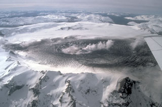
Geological Summary. The ice-filled, 10-km-wide caldera of Cerro Hudson volcano was not recognized until its first 20th-century eruption in 1971. It is the southernmost volcano in the Chilean Andes, related to subduction of the Nazca plate beneath the South American plate. The massive volcano covers an area of 300 km2. The compound caldera is drained through a breach on its NW rim, which has been the source of mudflows down the Río de Los Huemeles. Two cinder cones occur N of the volcano and others occupy the SW and SE flanks. This volcano has been the source of several major Holocene explosive eruptions. An eruption about 6,700 years ago was one of the largest known in the southern Andes during the Holocene; another eruption about 3,600 years ago also produced more than 10 km3 of tephra. An eruption in 1991 formed a new 800-m-wide crater in the SW portion of the caldera.
Information Contacts: SAB; G. Stephens, NOAA/NESDIS; N. Banks, USGS; Buenos AiresHerald.