Report on Whakaari/White Island (New Zealand) — December 1991

Bulletin of the Global Volcanism Network, vol. 16, no. 12 (December 1991)
Managing Editor: Lindsay McClelland.
Whakaari/White Island (New Zealand) Bombs and gas from deep October vent; occasional stronger explosions; deflation
Please cite this report as:
Global Volcanism Program, 1991. Report on Whakaari/White Island (New Zealand) (McClelland, L., ed.). Bulletin of the Global Volcanism Network, 16:12. Smithsonian Institution. https://doi.org/10.5479/si.GVP.BGVN199112-241040
Whakaari/White Island
New Zealand
37.52°S, 177.18°E; summit elev. 294 m
All times are local (unless otherwise noted)
During 5-6 December fieldwork, the new crater (Wade; figure 15) formed in mid-October continuously emitted a large white ash-poor gas plume. Booming and roaring noises were continuous, with some louder explosions that had only an occasional, delayed correlation with pulses of increased plume emission. Bombs (>1 m long) were ejected in near-vertical trajectories but rarely reached above the crater rim. Some of the few that landed on the rim were visibly incandescent on 6 December.
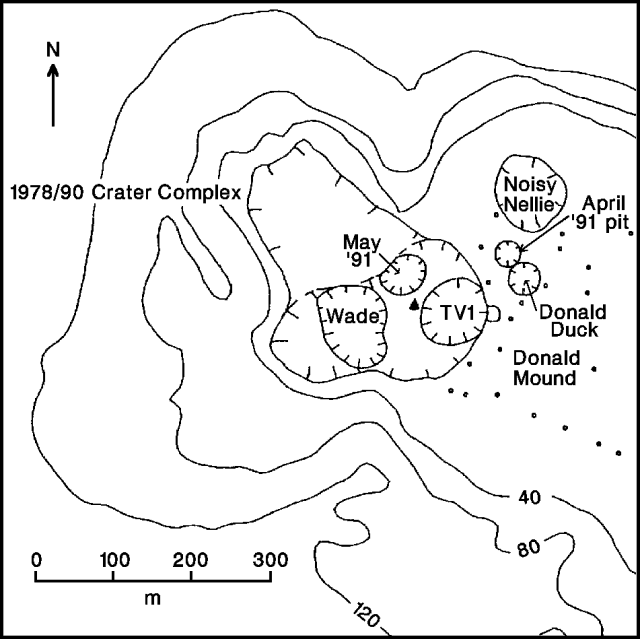 |
Figure 15. Sketch map of White Island's 1978/91 crater complex and adjacent parts of the main crater floor, showing positions of vents as of 6 December 1991. Courtesy of DSIR. |
The observations suggested to DSIR geologists that Wade Crater's conduit was relatively straight, extending down to the top of the magma body beneath White Island, perhaps at 300-400 m below sea level. Although most of the bombs produced by the resulting Strombolian activity did not escape the deep cylindrical conduit, occasional larger eruptions had scattered bombs (to 0.5 m across) over the main crater floor to 500 m from the vent. Comparison of 5-6 December photos with those taken 28 November revealed many new bombs, but all were ash-coated and did not appear to have been erupted in the last few days. A few altered lithic blocks (to 0.3 m across) occupied fresh impact craters > 200 m SE of the vent. The blocks were not coated with ash and were probably from recent explosions.
Since activity began at Wade Crater, almost 180 mm of tephra had been deposited ~100 m SE of the vent, and 55 mm had fallen at a site 100 m farther SE. Gray scoriaceous ash, lapilli, and bomb layers from the magma column alternated with red, thermally altered ash derived from reworked crater-fill sediments reamed out of the conduit. Major and trace element analyses at the Univ of Canterbury showed no significant changes between bombs collected on 29 August 1991 and samples collected in 1977 and 1979.
Fumarole discharge in the main crater remained at pressures and temperatures that were lower than normal. The highest fumarole temperature measured on 5 December was 353°C (at Noisy Nellie); the same vent was 411°C on 29 August.
Deformation data showed that deflation E of the active vent (in the Donald Mound area) had continued since the previous survey in late August, at similar rates. Subsidence had resumed in areas NE and SE of Donald Mound that had registered inflation in the August survey.
In the days following the 24 November explosion seismic data showed only a few A- and B-type events. Periods of intermittent low-amplitude low-frequency tremor were associated with a pair of E-type (explosion) shocks on 29 and 30 November; the eruption associated with the 30 November event was observed at 1006. The next day, another E-type event and observed eruption occurred at 1103. A gradual onset of medium-frequency tremor was noted ~2 hours later. No more E-type events were recorded through 9 December. A portable seismograph operated during the 6 December fieldwork recorded 2-3-second bursts of tremor-like vibration with frequencies of about 5 Hz during three of the stronger booming sounds from Wade Crater (at 1053, 1101, and 1148). However, similar tremor-like bursts were also recorded during the visit without accompanying loud booms.
Intermittent low-amplitude tremor began 4-6 December, strengthened 7-8 December, and reached high intensity on the 9th, when an eruption was next observed. A column rose to ~2,000 m at about 1440, apparently causing substantial ashfall on the island. Transmission of seismic data was intermittent on 9 December, and no data were available during the eruption.
Geological Summary. The uninhabited Whakaari/White Island is the 2 x 2.4 km emergent summit of a 16 x 18 km submarine volcano in the Bay of Plenty about 50 km offshore of North Island. The island consists of two overlapping andesitic-to-dacitic stratovolcanoes. The SE side of the crater is open at sea level, with the recent activity centered about 1 km from the shore close to the rear crater wall. Volckner Rocks, sea stacks that are remnants of a lava dome, lie 5 km NW. Descriptions of volcanism since 1826 have included intermittent moderate phreatic, phreatomagmatic, and Strombolian eruptions; activity there also forms a prominent part of Maori legends. The formation of many new vents during the 19th and 20th centuries caused rapid changes in crater floor topography. Collapse of the crater wall in 1914 produced a debris avalanche that buried buildings and workers at a sulfur-mining project. Explosive activity in December 2019 took place while tourists were present, resulting in many fatalities. The official government name Whakaari/White Island is a combination of the full Maori name of Te Puia o Whakaari ("The Dramatic Volcano") and White Island (referencing the constant steam plume) given by Captain James Cook in 1769.
Information Contacts: I. Nairn and C. Wood, DSIR Geology & Geophysics, Rotorua.