Report on Etna (Italy) — February 1992
Bulletin of the Global Volcanism Network, vol. 17, no. 2 (February 1992)
Managing Editor: Lindsay McClelland.
Etna (Italy) Continued flank lava production
Please cite this report as:
Global Volcanism Program, 1992. Report on Etna (Italy) (McClelland, L., ed.). Bulletin of the Global Volcanism Network, 17:2. Smithsonian Institution. https://doi.org/10.5479/si.GVP.BGVN199202-211060
Etna
Italy
37.748°N, 14.999°E; summit elev. 3357 m
All times are local (unless otherwise noted)
The following is from a report by the Gruppo Nazionale per la Vulcanologia (GNV) summarizing Etna's 1991-92 eruption.
1. Introduction and Civil Protection problems. After 23 months of quiet, and heralded by ground deformation and a short seismic swarm, effusive activity resumed at Etna early 14 December. The eruptive vent opened at 2,200 m elevation on the W wall of the Valle del Bove, along a SE-flank fracture that formed during the 1989 eruption.
Since the eruption's onset, the GNV, in cooperation with Civil Protection authorities, has reinforced the scientific monitoring of Etna. Attention was focused on both the advance of the lava flow and on the possibility of downslope migration of the eruptive vent along the 1989 fracture system. The progress of the lava flow has been carefully followed by daily field inspections and helicopter overflights.
Because of its slow rate of advance, the lava did not threaten lives, but had the potential for severe property destruction. The water supply system for Zafferana (in Val Calanna; figure 43) was destroyed in the first two weeks of the eruption ($2.5 million damage). On 1 January, when the lava front was only 2 km from Zafferana, the Minister for Civil Protection, at the suggestion of the volcanologists, ordered the building of an earthen barrier to protect the village. The barrier was erected at the E end of Val Calanna, where the valley narrows into a deeply eroded canyon. The barrier was conceived to prevent or delay the flow's advance, not to divert it, by creating a morphological obstacle that would favor flow overlapping and lateral expansion of the lava in the large Val Calanna basin.
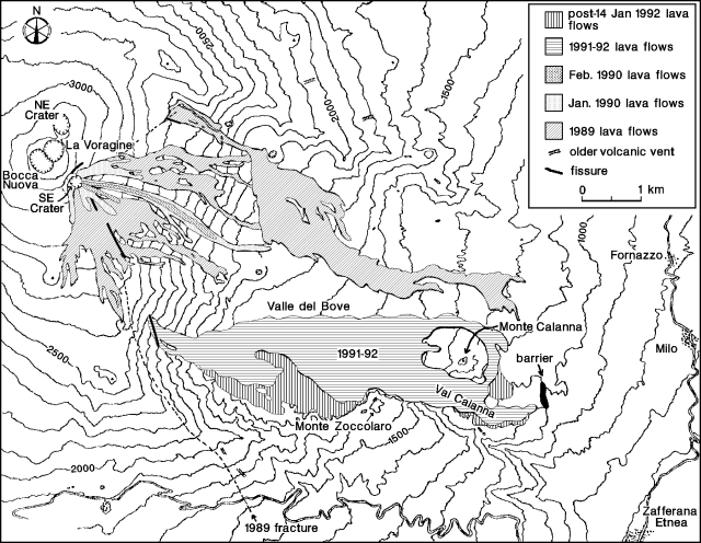 |
Figure 43. Topographic sketch map showing Etna's 1989 and 1990 lava flows, with preliminary locations of the 1991-92 lava, eruptive fissures, and the barrier constructed in Val Calanna. The area covered by lava since 14 January is shown in a separate pattern. The GNV report, received near press time, included a map that differed somewhat in detail from this map, which was prepared by R. Romano, T. Caltabiano, P. Carveni, M.F. Grasso, and C. Monaco. See pg.4 of Barberi et al., 1990 for a map of the 1989 lava flows, fissures, and monitoring network. |
The barrier, erected by specialized Army and Fire Brigade personnel in 10 days of non-stop work, is ~ 250 m long and ~ 20 m higher than the adjacent Val Calanna floor. It was built by diking the valley bottom in front of the advancing lava and accumulating loose material (earth, scoria, and lava fragments) on a small natural scarp. On 7 January, the lava front approached to a few tens of meters from the barrier, then stopped because of a sudden drop in feeding caused by a huge lava overflow from the main channel several kilometers upslope.
A decrease in the effusion rate has been observed since mid-January. There is therefore little chance of further advance of the front, as the flow seems to have reached its natural maximum length. The eruptive fracture is being carefully monitored (seismicity, ground deformation, geoelectrics, gravimetry, and gas geochemistry) to detect early symptoms of a possible dangerous downslope migration of the vent along the 1989 fracture, which continues along the present fracture's SE trend. Preparedness plans were implemented in case of lava emission from the fracture's lower end.
Many scientists and technicians, the majority of whom are from IIV and the Istituto per la Geochimica dei Fluidi, Palermo (IGF) and are coordinated by GNV, are collecting information on the geological, petrological, geochemical, and geophysical aspects of the eruption.
2. Eruption chronology. On 14 December at about 0200, a seismic swarm (see Seismicity section below) indicated the opening of two radial fractures trending NE and SSE from Southeast Crater. Very soon, ash and bombs formed small scoria ramparts along the NE fracture, where brief activity was confined to the base of Southeast Crater. Meanwhile, a SSE-trending fracture extended ~ 1.3 km from the base of the crater (at ~3,000 m asl) to 2,700 m altitude.
Lava fountaining up to 300 m high from the uppermost section of the SSE fracture continued until about 0600, producing scoria ramparts 10 m high. Two thin (~ 1 m thick) lava flows from the fracture moved E. The N flow, from the highest part of the fracture, stopped at 2,750 m altitude, while the other, starting at 2,850 m elevation, reached the rim of the Valle del Bove (in the Belvedere area), pouring downvalley to ~ 2,500 m asl. At noon, the lava flows stopped, while the W vent of the central crater (Bocca Nuova) was the source of intense Strombolian activity.
The SSE fracture system continued to propagate downslope, crossing the rim of the Valle del Bove in the late evening. During the night of 14-15 December, lava emerged from the lowest segment of the fracture cutting the W flank of the Valle del Bove, reaching 2,400 m altitude (E of Cisternazza). Degassing and Strombolian activity built small scoria cones. Two lava flows advanced downslope from the base of the lower scoria cone at an estimated initial velocity of 15 m/s, which dramatically decreased when they reached the floor of the Valle del Bove.
The SSE fractures formed a system 3 km long and 350-500 m wide that has not propagated since 15 December. Between Southeast Crater and Cisternazza, the fracture field includes the 1989 fractures, which were reactivated with 30-50-cm offsets. The most evident offsets were down to the E, with right-lateral extensional movements. Numerous pit craters, <1 m in diameter, formed along the fractures.
Lava flows have been spreading down the Valle del Bove into the Piano del Trifoglietto, advancing a few hundred meters/day since 15 December. The high initial outflow rates peaked during the last week of 1991 and the first few days of 1992, and decreased after the second week in January. Strombolian activity at the vent in the upper part of the fracture has gradually diminished.
Lava flows were confined to the Valle del Bove until 24 December, when the most advanced front extended beyond the steep slope of the Salto della Giumenta (1,300-1,400 m altitude), accumulating on the floor of Val Calanna. Since then, many ephemeral vents and lava tubes have formed in the area N of Monte Zoccolaro, probably because of variations in the eruption rate. These widened the lava field in the area, and decreased feeding for flows moving into Val Calanna. However, by the end of December, lava flows expanded further in Val Calanna, moving E and threatening the village of Zafferana Etnea, ~2 km E of the most advanced flow front. This front stopped on 3 January, on the same day that a flow from the Valle del Bove moved N of Monte Calanna, later turning back southward and rejoining lava that had already stopped in Val Calanna. Since 9 January, lava flows in Val Calanna have not extended farther downslope, but have piled up a thick sequence of lobes.
Lava outflow from the vent continued at a more or less constant rate, producing a lava field in the Valle del Bove that consisted of a complex network of tubes and braiding, superposing flows, with a continuously changing system of overflows and ephemeral vents.
3. Lava flow measurements. An estimate of lava channel dimensions, flow velocity, and related rheological parameters was carried out where the flow enters the Valle del Bove. Flow velocities ranging from 0.4-1 m/s were observed 3-7 January in a single flow channel (10 m wide, ~ 2.5 m deep) at 1,800 m altitude, ~ 600 m from the vent. From these values, a flow rate of 8-25 m3/s and viscosities ranging from 70-180 Pas were calculated. Direct temperature measurements at several points on the flow surface with an Al/Ni thermocouple and a 2-color pyrometer (HOTSHOT) yielded values of 850-1,080°C.
4. Petrography and chemistry. Systematic lava sampling was carried out at the flow fronts and near the vents. All of the samples were porphyritic (P.I.»25-35%) and of hawaiitic composition, differing from the 1989 lavas, which fall within the alkali basalt field. Paragenesis is typical of Etna's lavas, with phenocrysts (maximum dimension, 3 mm) of plagioclase, clinopyroxene, and olivine, with Ti-magnitite microphenocrysts. The interstitial to hyalopitic groundmass showed microlites of the same minerals.
5. Seismicity. On 14 December at 0245, a seismic swarm occurred in the summit area (figure 44), related to the opening of upper SE-flank eruptive fractures. About 270 earthquakes were recorded, with a maximum local magnitude of 3. A drastic reduction in the seismic rate was observed from 0046 on 15 December, with only four events recorded until the main shock (Md 3.6) of a new sequence occurred at 2100. The seismic rate remained quite high until 0029 on 17 December, declining gradually thereafter.
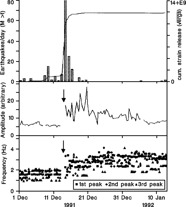 |
Figure 44. Daily number of recorded earthquakes and cumulative strain release (top), with amplitude (middle) and dominant frequency peaks of volcanic tremor (bottom) at Etna, 1 December 1991-mid-January 1992. Arrows mark the eruption's onset. Courtesy of the Gruppo Nazionale per la Vulcanologia. |
At least three different focal zones were recognized. On 14 December, one was located NE of the summit and a second in the Valle del Bove. The third, SW of the summit, was active on 15 December. All three focal zones were confined to <3 km depth. Three waveform types were recognized, ranging from low-to-high frequency.
As the seismic swarm began on 14 December, volcanic tremor amplitude increased sharply. Maximum amplitude was reached on 21 December, followed by a gradually decreasing trend. As the tremor amplitude increased, the frequency pattern of its dominant spectral peaks changed, increasing within a less-consistent frequency trend. Seismicity rapidly declined and remained at low levels despite the ongoing eruption.
6. Ground deformation. EDM measurements and continuously recording shallow-borehole tiltmeters have been used for several years to monitor ground deformation at Etna. The tilt network has recently grown to 9 flank stations. A new tilt station (CDV) established on the NE side of the fracture in early 1990 showed a steady radial-component increase in early March 1991 after a sharp deformation event at the end of 1990 (figure 45), suggesting that pressure was building into the main central conduit. Maximum inflation was reached by October 1991, followed by a partial decrease in radial tilt, tentatively related to magma intrusion into the already opened S branch of the 1989 fracture system, perhaps releasing pressure in the central conduit.
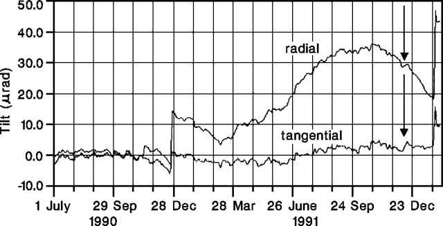 |
Figure 45. Radial and tangential components measured by the CDV borehole tilt station on the NE side of Etna's 1989 fracture, 1 July—mid-January 1992. The signal has been filtered for daily and seasonal thermoelastic noise. Arrows mark the eruption's onset. Courtesy of the Gruppo Nazionale per la Vulcanologia. |
The eruption's onset was clearly detected by all flank tilt stations, despite their distance from the eruption site. The signals clearly record deformation events closely associated in time with seismic swarms on the W flank (before the eruption began) and on the summit and SW sector (after eruption onset). The second swarm heralded the opening of the most active vent on the W wall of the Valle del Bove.
S-flank EDM measurements detected only minor deformation, in the zone affected by the 1989 fracture. Lines crossing the fracture trend showed brief extensions in January 1992.
The levelling route established in 1989 across the SE fracture was reoccupied 18-19 December 1991. A minor general decline had occurred since the previous survey (October 1990), with a maximum (-10 mm) at a benchmark near the fracture.
7. Gravity changes. Microgravity measurements have been carried out on Etna since 1986, using a network covering a wide area between 1,000 and 1,900 m asl. A reference station is located ~ 20 km NE of the central crater. Five new surveys were made across the 1989 fissure zone during the eruption (15 & 18 December 1991, and 9, 13, and 18 January 1992). Between 21 November and 15 December, the minimum value of gravity variations was about -20 mGal, E of the fracture zone. On 9 January, the gravity variations inverted to a maximum of about +15 mGal. Amplitude increased and anomaly extension was reduced on 13 January, and on 18 January gravity variations were similar to those 9 days earlier. Assuming that height changes were negligible, a change in mass of ~2 x 10⁶ tons (~2 x 10⁷ m3 volume), for a density contrast of 0.1 g/cm3 was postulated. However, if gravity changes were attributed to magma movement, a density contrast of 0.6 g/cm3 between magma and country rock could be assumed and magma displacement would be ~ 3 x 10⁶ m3.
8. Magnetic observations. A 447-point magnetic surveillance array was spaced at 5-m intervals near the fracture that cut route SP92 in 1989. Measurements of total magnetic field intensity (B) have been carried out at least every 3 months since October 1989. Significant long-term magnetic variations were not observed between February 1991 and January 1992, although the amplitude of variations seems to have increased since the beginning of the eruption.
9. Self-potential. A program of self-potential measurements along an 1.32-km E-W profile crossing the SE fracture system (along route SP92 at ~ 1,600 m altitude) began on 25 October 1989. Two large positive anomalies were consistently present during measurements on 5 and 17 January, and 9, 18, and 19 February 1992. The strongest was centered above the fracture system, the second was displaced to the W. Only the 5 January profile hints at the presence of a third positive anomaly, on its extreme E end. The persistent post-1989 SP anomalies could be related to a magmatic intrusion, causing electrical charge polarizations inside the overlying water-saturated rocks. A recent additional intrusion was very likely to have caused the large increase in amplitude and width of the SP anomaly centered above the fracture system, detected on the E side of the profile on 5 January 1992.
10. COSPEC measurements of SO2 flux. The SO2 flux from Etna during the eruption has been characterized by fairly high values, averaging ~ 10,000 t/d, ~ 3 times the mean pre-eruptive rate. Individual measurements varied between ~6,000 and 15,000 t/d.
11. Soil gases. Lines perpendicular to the 1989 fracture, at ~ 1,600 m altitude, have been monitored for CO2 flux. A sharp increase in CO2 output was recorded in September 1991, about 3 months before the eruption began (figure 46). Measurements have been more frequent since 17 December, but no significant variation in CO2 emission has been observed. Samples of soil gases collected at 50 cm depth showed a general decrease in He and CO2 contents since the beginning of January. Soil degassing at two anomalous exhalation areas, on the lower SW and E flanks at ~ 600 m altitude, dropped just before (SW flank—Paternò) and immediately after (E flank—Zafferana) the beginning of the eruption, and remained at low levels. A significant radon anomaly was recorded 26-28 January along the 1989 fracture, but CO2 and radon monitoring have been hampered by snow.
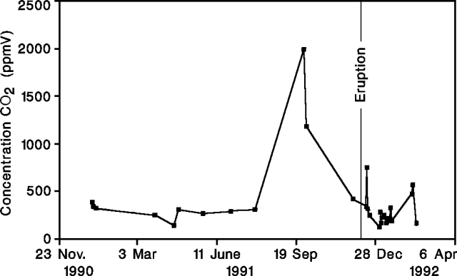 |
Figure 46. CO2 concentrations measured along Etna's 1989 fracture, late 1990-early 1992, showing a strong increase about 3 months before the December 1991 eruption. Courtesy of the Gruppo Nazionale per la Vulcanologia. |
The following, from R. Romano, describes activity in February and early March.
The SE-flank fissure eruption was continuing in early March, but was less vigorous than in previous months. An area of ~ 7 km2 has been covered by around 60 x 106 m3 of lava, with an average effusion rate of 8 m3/s. The size of the lava field (figure 43) has not increased since it reached a maximum width of 1.7 km in mid-February.
Lava from fissure vents at ~ 2,100 m asl flowed in an open channel to 1,850 m altitude, then advanced through tubes. Flowing lava was visible in the upper few kilometers of the tubes through numerous skylights. Lava emerged from the tube system through as many as seven ephemeral vents on the edge of the Salto della Giumenta (at the head of the Val Calanna, ~ 4.5 km from the eruptive fissure). These fed a complex network of flows in the Salto della Giumenta that were generally short and not very vigorous. None extended beyond the eruption's longest flow, which had reached 6.5 km from the eruptive fissure (1,000 m asl) before stopping in early January. Ephemeral vent activity upslope (within the Valle del Bove) ceased by the end of February. Lava production from fissure vents at 2,150 m altitude has gradually declined and explosive activity has stopped. Degassing along the section of the fissure between 2,300 and 2,200 m altitude was also gradually decreasing.
Small vents were active at the bottom of both central craters. Activity at the west crater (Bocca Nuova) was generally limited to gas emission, but significant ash expulsions were observed during the first few days in March. High-temperature gases emerged from the E crater (La Voragine). Collapse within Northeast Crater, probably between 26 and 27 February, was associated with coarse ashfalls on the upper NE flank (at Piano Provenzana and Piano Pernicana). After the collapse, a new pit crater ~ 50 m in diameter occupied the site of Northeast Crater's former vent. Activity from Southeast Crater was limited to gas emission from a modest-sized vent.
Seismic activity was characterized by low-intensity swarms. A few shocks were felt in mid-February ~ 12 km SE of the summit (in the Zafferana area).
Reference. Barberi, F., Bertagnini, F., and Landi, P., eds., 1990, Mt. Etna: the 1989 eruption: CNR-Gruppo Nazionale per la Vulcanologia: Giardini, Pisa, 75 p. (11 papers).
Geological Summary. Mount Etna, towering above Catania on the island of Sicily, has one of the world's longest documented records of volcanism, dating back to 1500 BCE. Historical lava flows of basaltic composition cover much of the surface of this massive volcano, whose edifice is the highest and most voluminous in Italy. The Mongibello stratovolcano, truncated by several small calderas, was constructed during the late Pleistocene and Holocene over an older shield volcano. The most prominent morphological feature of Etna is the Valle del Bove, a 5 x 10 km caldera open to the east. Two styles of eruptive activity typically occur, sometimes simultaneously. Persistent explosive eruptions, sometimes with minor lava emissions, take place from one or more summit craters. Flank vents, typically with higher effusion rates, are less frequently active and originate from fissures that open progressively downward from near the summit (usually accompanied by Strombolian eruptions at the upper end). Cinder cones are commonly constructed over the vents of lower-flank lava flows. Lava flows extend to the foot of the volcano on all sides and have reached the sea over a broad area on the SE flank.
Information Contacts: GNV report:F. Barberi, Univ di Pisa; L. Villari, IIV. February-early March activity:R. Romano and T. Caltabiano, IIV; P. Carveni, M. Grasso, and C. Monaco, Univ di Catania.
The following people provided information for the GNV report. Institutional affiliations (abbreviated, in parentheses) and their report sections [numbered, in brackets] follow names.
F. Barberi (UPI) [1, 2], A. Armantia (IIV) [2], P. Armienti (UPI) [2, 4], R. Azzaro (IIV) [2], B. Badalamenti (IGF) [11], S. Bonaccorso (IIV) [6], N. Bruno (IIV) [10], G. Budetta (IIV) [7, 8], A. Buemi (IIV) [4],
T. Caltabiano (IIV) [8, 10], S. Calvari (IIV) [2, 3], O. Campisi (IIV) [6], M. Carà (IIV) [10], M. Carapezza (IGF, UPA) [11], C. Cardaci (IIV) [5], O. Cocina (UGG) [5], D. Condarelli (IIV) [5], O. Consoli (IIV) [6],
W. D'Alessandro (IGF) [11], M. D'Orazio (UPI) [2, 4], C. Del Negro (IIV) [7, 8], F. DiGangi (IGF) [11], I. Diliberto (IGF) [11], R. Di Maio (DGV) [9], S. DiPrima (IIV) [5], S. Falsaperla (IIV) [5], G. Falzone (IIV) [6], A. Ferro (IIV) [5], F. Ferruci (GNV) [5], G. Frazzetta (UPI) [2],
H. Gaonac'h (UMO) [2, 3], S. Giammanco (IGF) [11], M. Grasso (IIV) [10], M. Grimaldi (DGV) [7], S. Gurrieri (IGF) [11], F. Innocenti (UPI) [4], G. Lanzafame (IIV) [2], G. Laudani (IIV) [6], G. Luongo (OV) [6], A. Montalto (IIV, UPI) [5], M. Neri (IIV) [2], P. Nuccio (IGF, UPA) [11],
F. Obrizzo (OV) [6], F. Parello (IGF, UPA) [11], D. Patanè (IIV) [5], D. Patella (DGV) [9], A. Pellegrino (IIV) [5], M. Pompilio (IIV) [2, 3, 4], M. Porto (IIV) [10], E. Privitera (IIV) [5], G. Puglisi (IIV) [2, 6], R. Romano (IIV) [10], A. Rosselli (GNV) [5], V. Scribano (UCT) [2], S. Spampinato (IIV) [5], C. Tranne (IIV) [2], A. Tremacere (DGV) [9], M. Valenza (IGF, UPA) [11], R. Velardita (IIV) [6], L. Villari (IIV) [1, 2, 6].
Institutions: DGV: Dipto di Geofisica e Vulcanologia, Univ di Napoli; GNV: Gruppo Nazionale per la Vulcanologia, CNR, Roma; IGF: Istituto per la Geochimica dei Fluidi, CNR, Palermo; IIV: Istituto Internazionale di Vulcanologia, CNR, Catania; OV: Osservatorio Vesuviano, Napoli; UCT: Istituto di Scienze della Terra, Univ di Catania; UGG: Istituto di Geologia e Geofisica, Univ di Catania; UMO: Dept de Géologie, Univ de Montréal; UPA: Istituto di Mineralogia, Petrologia, e Geochimica, Univ di Palermo; UPI: Dipto di Scienze della Terra, Univ di Pisa.