Report on Irazu (Costa Rica) — February 1992

Bulletin of the Global Volcanism Network, vol. 17, no. 2 (February 1992)
Managing Editor: Lindsay McClelland.
Irazu (Costa Rica) Fumarolic activity in and around crater lake; continued seismicity; deflation
Please cite this report as:
Global Volcanism Program, 1992. Report on Irazu (Costa Rica) (McClelland, L., ed.). Bulletin of the Global Volcanism Network, 17:2. Smithsonian Institution. https://doi.org/10.5479/si.GVP.BGVN199202-345060
Irazu
Costa Rica
9.979°N, 83.852°W; summit elev. 3436 m
All times are local (unless otherwise noted)
Fumarolic activity continued in February. Although the water level continued to drop, the crater lake remained larger than it had been in November (figure 5 and table 3). Water temperatures (measured by UNA) on the N side of the lake near the most active subaqueous fumaroles ranged from 37°C to 73°C; bubbling springs near the edge of the lake were
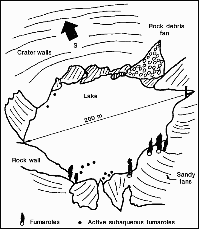 |
Figure 5. Oblique view of the crater lake at Irazú, 25 February 1992. Courtesy of ICE. |
Table 3. Crater lake characteristics at Irazú, November 1991 and February 1992. Courtesy of ICE.
| Date | Diameter | Max. Depth | Est. Volume | Avg. Temp. | Min. pH |
| 19 Nov 1991 | 195 m | 14.35 m | 280,000 m3 | 26.7°C | 2.85 |
| 12 Feb 1992 | 202 m | 15.25 m | 330,000 m3 | 28.3°C | 3.23 |
A monthly total of 234 earthquakes was recorded in February (at UNA station IRZ2, 5 km WSW of the crater), with a maximum of 37 on 21 February. Nine high-frequency earthquakes were recorded in February. Measurements of two geodetic lines across the summit on 13 February indicated contractions of 6.4 ppm in an E-W direction and 15.8 ppm in a N-S direction, since 10 October 1991 (UNA).
Geological Summary. The massive Irazú volcano in Costa Rica, immediately E of the capital city of San José, covers an area of 500 km2 and is vegetated to within a few hundred meters of its broad summit crater complex. At least 10 satellitic cones are located on its S flank. No lava effusion is known since the eruption of the Cervantes lava flows from S-flank vents about 14,000 years ago, and all known Holocene eruptions have been explosive. The focus of eruptions at the summit crater complex has migrated to the W towards the main crater, which contains a small lake. The first well-documented eruption occurred in 1723, and frequent explosive eruptions have occurred since. Ashfall from the last major eruption during 1963-65 caused significant disruption to San José and surrounding areas. Phreatic activity reported in 1994 may have been a landslide event from the fumarolic area on the NW summit (Fallas et al., 2018).
Information Contacts: E. Fernández, J. Barquero, V. Barboza, and R. Van der Laat, OVSICORI; G. Soto and R. Barquero, ICE.