Report on Spurr (United States) — March 1992

Bulletin of the Global Volcanism Network, vol. 17, no. 3 (March 1992)
Managing Editor: Lindsay McClelland.
Spurr (United States) Earthquake swarms but no indication of imminent eruption
Please cite this report as:
Global Volcanism Program, 1992. Report on Spurr (United States) (McClelland, L., ed.). Bulletin of the Global Volcanism Network, 17:3. Smithsonian Institution. https://doi.org/10.5479/si.GVP.BGVN199203-313040
Spurr
United States
61.299°N, 152.251°W; summit elev. 3374 m
All times are local (unless otherwise noted)
In January-February 1992, seismic activity was at the highest levels since the start of monitoring in 1980, although there is no indication that an eruption is imminent. This activity followed a significant increase in August 1991, when earthquakes began to occur beneath Crater Peak, a region that had been almost quiescent since monitoring began (figures 1 and 2). During January-July 1991, within a 10-km radius of the volcano, an average of 2 earthquakes (M>0) were recorded every 10 days. This average increased to 7 earthquakes/10 days in August-November 1991, and again to 20 earthquakes/10 days in December 1991-February 1992. Most of the earthquakes had magnitudes <1 and depths <5 km. Since November 1991, the majority of the earthquakes have been centered beneath the main summit and Crater Peak, with a zone of lesser activity 5 km N of the main summit.
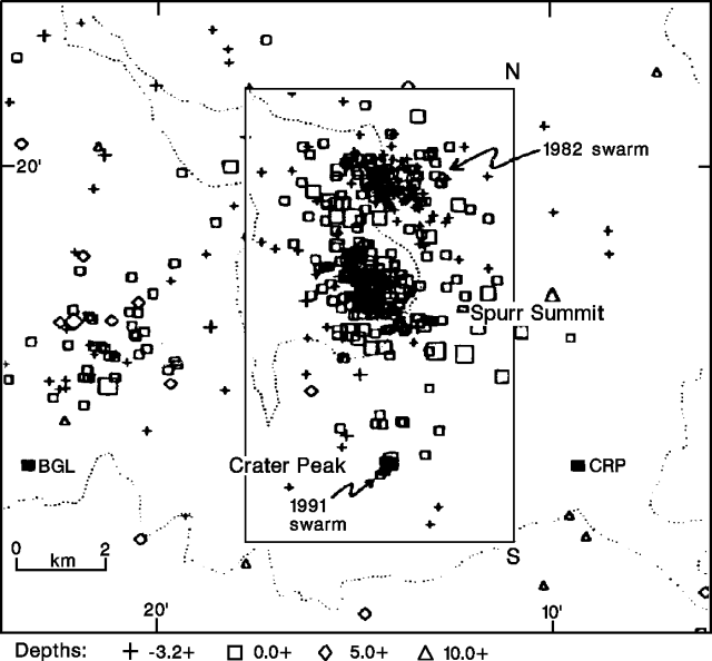 |
Figure 1. Map of earthquake epicenters near Spurr, 1981-August 1991. Filled rectangles labeled with 3-letter codes mark nearby seismic stations. Printed by permission of the Scientist-in-Charge, Alaska Volcano Observatory. |
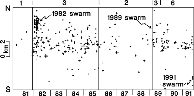 |
Figure 2. Time vs. distance plot of hypocenters at Spurr, 1981-August 1991. Distance is measured by projecting events on a N-S line in figure 1. The number of seismic stations operating in the Spurr area is shown along the top. Hypocenters for the 1989 swarm could not be determined as only two stations were operating at the time. Printed by permission of the Scientist-in-Charge, Alaska Volcano Observatory. |
Seismicity at Spurr has been characterized by large fluctuations in the number of events. Large earthquake swarms were recorded in early 1982 (>140 events recorded) and in early 1989 (not shown in figure 2), both centered 3 km N of the main summit. Normal seismicity has tended to concentrate beneath the main summit.
On 9 July 1953, a brief explosive eruption from Crater Peak produced a 21-km-high plume that dropped ash in Anchorage (120 km E). A mudflow blocked the Chakachatna River (S flank), forming a lake 8 km long.
Reference. Nye, C.J., and Turner, D.L., 1990, Petrology, geochemistry, and age of the Spurr Volcanic Complex, eastern Aleutian Arc: BV, v. 52, p. 205-226.
Geological Summary. Mount Spurr is the closest volcano to Anchorage, Alaska (130 km W) and just NE of Chakachamna Lake. The summit is a large lava dome at the center of a roughly 5-km-wide amphitheater open to the south formed by a late-Pleistocene or early Holocene debris avalanche and associated pyroclastic flows that destroyed an older edifice. The debris avalanche traveled more than 25 km SE, and the resulting deposit contains blocks as large as 100 m in diameter. Several ice-carved post-collapse cones or lava domes are present. The youngest vent, Crater Peak, formed at the southern end of the amphitheater and has been the source of about 40 identified Holocene tephra layers. Eruptions from Crater Peak in 1953 and 1992 deposited ash in Anchorage.
Information Contacts: AVO.