Report on Etna (Italy) — May 1992
Bulletin of the Global Volcanism Network, vol. 17, no. 5 (May 1992)
Managing Editor: Lindsay McClelland.
Etna (Italy) Fissure eruption continues; lava diverted; lava field described
Please cite this report as:
Global Volcanism Program, 1992. Report on Etna (Italy) (McClelland, L., ed.). Bulletin of the Global Volcanism Network, 17:5. Smithsonian Institution. https://doi.org/10.5479/si.GVP.BGVN199205-211060
Etna
Italy
37.748°N, 14.999°E; summit elev. 3357 m
All times are local (unless otherwise noted)
The following is from R. Romano. Lava production from the fissure ... was continuing without noticeable variation in mid-June. Gas emission, from four explosion vents between 2,335 and 2,215 m elevation, has diminished along the upper part of the fissure. The main lava channel has roofed over, but lava was visible through a skylight beginning at 2,205 m elevation, where the effusion rate was estimated at 6-8 m3/s and the flow velocity at ~ 1 m/s on 7 and 13 June. Three more skylights were open along the main channel to 2,020 m asl. An overflow occurred on 12 June from one of the skylights, at 2,075 m altitude, but lava advanced only a few meters before returning to the main channel. This overflow was still active the next day. Ephemeral vents from the main tube remained active through the end of May: in the Valle del Bove; below the Valle del Bove in Val Calanna; and near the distal end of the flow field, along a deep gully under Portella Calanna (figure 48). Lava flows emerged more or less continuously from the latter vents, but did not descend below 800 m altitude. The total volume of lava produced by the eruption is estimated at 150 x 106 m3.
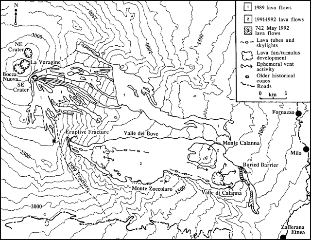 |
Figure 48. Status of activity within Etna's flow field on 18 May 1992, after 153 days of activity. Modified by Hughes and Bulmer from map by Romano in 17:4. Contour interval, 100 m. |
Lava diversion. An earthen barrier built in a valley above the town of Zafferana Etnea in early January was breached by lava on 7 April. Lava overran a series of additional barriers the following week but stopped before reaching the town. Subsequent hazards efforts focused on reducing the lava supply to the end of the flow, by obstructing the main lava tube near the vent and disrupting lava production at ephemeral vents (17:3-4).
F. Barberi and L. Villari report successful lava diversion from the main tube, at a site 500 m downslope from the primary eruptive vent. In this area, at ~ 2,000 m elevation on the W wall of the Valle del Bove, lava was carried through a single tube locally broken by skylights. On 27 May, about 2/3 of the tube's lava was diverted into an artificially excavated channel by blasting through the 2-3-m-thick wall of the right levee. Two days later, bulldozers obstructed the natural channel by pushing large blocks of lava into it. By 1815 that day, all of the lava output (~30 m3/s) was flowing into the artificial channel. In effect, the diversion returned the active flow front to its position a few days after the onset of the eruption. Lava was moving downslope along the same path as the earlier main flow, but was > 6 km upslope from its previously most advanced front.
Flows generated by lava diversion efforts. R. Romano reports that as of 13 June, a vent remained active at the site of the first lava diversion. Although the vent has been shrinking, it continued to feed a flow that has advanced over lava from previous months, forming tubes and various ephemeral vents, many of which were near the S wall of the Valle del Bove. The ephemeral vents produced two lava flows, one near the S wall of the Valle del Bove at around 1,700 m elevation, the other in a more central position, at ~ 1,800 m asl on the main lava field. The lava flows that formed after the first diversion advanced more than a kilometer over the center of the lava field. Flows that followed the second diversion remained predominantly near the S wall of the Valle del Bove, passing and encircling a site at 1,575 m asl (Poggio Canfareddi), 2 km from their point of origin, on 3 June. This lava front stopped advancing on 5 June and several superposing lobes began to develop.
Seismicity and summit activity. Weak seismic activity began on 29 May, followed by an increase in volcanic tremor on 31 May that continued until the next day. Ash emissions, sometimes voluminous, occurred from the central craters at irregular intervals on 31 May and 1 June, first from the W vent (Bocca Nuova) then from the E vent (La Voragine). Only weak degassing preceded the ash ejection, but gas emission became more consistent beginning 2 June. COSPEC measurements yielded SO2 flux values of ~ 10,000 t/d. Flashes from the summit craters were observed during the evening of 7 June from the W flank. Fieldwork on 12 June revealed that Northeast Crater was obstructed, with only fumarolic activity along the walls.
EDM data. S. Saunders reports that four lines of an EDM network on the upper S flank were remeasured on 7 May, showing a 138-ppm contraction that was interpreted as deflation during the eruption. Between July and October 1991, total extensional strain along these lines was 88 ppm, indicating pre-eruption inflation. Strain along these lines has returned to near pre-eruption levels.
Landsat Thematic Mapper data. The following is from D. Rothery. "The 1991-92 sustained lava eruption of Etna provides an opportunity to study lava flow development by remote sensing. The first cloud-free Landsat Thematic Mapper (TM) image of the eruption was recorded on 2 January at approximately 1000 (figure 49). Landsat repeats its coverage on a 16-day cycle; the next cloud-free acquisition was on 22 March and we are still awaiting receipt of those data. By manipulating radiance measurements in two wavebands, we hope to be able to constrain the surface temperature distribution of this flow along its length. The most noteworthy aspects of the 2 January data are: 1) There is a narrow 700-m length near the source that is radiant in TM band 4 (0.76-0.90 mm wavelength). As far as we know, this is the first time that thermal radiance in TM band 4 has been reported over a volcano. Field observations (A. Borgia) on 2 and 3 January show that this feature corresponds to a 10-15-m-wide open channel at the source of the flow. 2) The entire 6.5-km-long active flow is radiant in TM band 7 (2.08-2.35 mm wavelength). At least some of the areas that are also radiant in band 5 (1.55-1.75 mm) occur when the flow spills down a steep slope, breaking apart the raft of blocks and crust that otherwise blanket the underlying lava at near-magmatic temperatures."
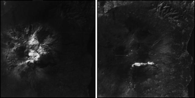 |
Figure 49. Extracts of Landsat TMr images of Etna, 2 January 1992, in band 4 (0.76-0.90 mm wavelength, left) and band 7 (2.08-2.35 mm wavelength, right) at pixel sizes of 30 x 30 m. In band 4, much of Etna is snow-covered (white), while the active lava flow is the darkest land feature because of its very low reflectance in this part of the spectrum (very-near infrared). Thermal radiance is confined to a narrow channel near the source and is not evident at this scale. In band 7, the active flow is radiant through most of its length. Bright lines are caused by sensor overload. Courtesy of D. Rothery. |
Lava field characteristics. The following is an excerpt from a preliminary report by Wyn Hughes and Mark Bulmer, describing the eruption as of 18 May.
Lava leaving the eruptive vent advanced through a tube system that extended downslope to the foot of the western backwall of the Valle del Bove at 1,850 m asl. Several skylights were spaced at intervals along it. At the break in slope, numerous active ephemeral vents issued new lava-flow units onto the surface of the flow field (figure 48). These did not travel far from their source. Surface activity was otherwise absent within the Valle del Bove; lava was being efficiently transported through tubes toward the flow front. One tube system (with skylights and fume) could be traced through the center of the flow field in the Valle del Bove, toward Val Calanna. At the distal end of the Valle del Bove, several pressure ridges were visible, oriented perpendicular to the underlying ground slope.
Most of the surface activity was occurring in Val Calanna, where intense ephemeral vent activity was issuing new lava-flow units onto the flow-field surface. Lava was being supplied to this area through a series of tubes that descended from the Valle del Bove. Most of the activity in Val Calanna appeared to be supplied by a major tube system that could be traced (by skylights and fume) descending the backwall along its S margin (Salto della Giumenta). A smaller tube system probably supplied some ephemeral vents on the N margin of Val Calanna (S foot of Mte. Calanna).
In Val Calanna, effusive activity was mainly concentrated along the S margin of the flow field, where lava had ponded along the S wall of Val Calanna, and behind the man-made earthen barrier. From there, ephemeral vents in the crust fed numerous new lava-flow units, supplying three regions. Where lava moved directly NE, these were progressively widening the flow field at 1,050 m altitude. Flows that initially moved NE, but then changed to a more easterly direction, were supplying units that flowed around the N margin of the buried man-made barrier. Near the barrier, although active aa-textured flow fronts and channel-fed flow units could be traced on the surface of the flow field, most of the activity that contributed to its widening was supplied from tubes in the previous days' flow units. Ephemeral vents at 1,000 m elevation on the N margin of the buried man-made barrier supplied new flow units that were widening the field to the NE. However, these flow units were abutting the distal levee of the 1852-53 flow field, which was largely hindering the widening. On 18 May, some of these slow-moving tube-fed lavas managed to flow out of Val Calanna, and began the steep descent towards Zafferana. This activity was occurring on the NE side of the flow field. Three ephemeral vents had opened just below the S margin of the man-made barrier. A short distance downslope, flows from these vents combined to feed a front that advanced quite rapidly down the SW side of the flow field on the night of 17 May. By the next morning, and after destroying an abandoned dwelling during the night, the rate of advance had decreased, with the front at ~ 870 m asl. All of these active regions were being channel/tube-fed by lava from along the S wall of Val Calanna, which in turn was being supplied by tubes that descended from the Valle del Bove.
Flow-field morphology. Although the flow field was widening somewhat towards the NE end of Val Calanna, the activity was dominated by ephemeral vents extruding new flow units onto the surface of the original field. This was mainly occurring at ~ 1,800 and 1,050 m altitude, where the backwalls of the Valle del Bove and Val Calanna give way to their respective floors (figures 48 and 50). The surface activity was rapidly burying aa channel-fed flow units from early in the eruption. They could only be seen among the flows that had gone around the N margin of Mte. Calanna, and as isolated inliers on the floor of Val Calanna.
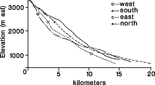 |
Figure 50. Profile of the pre-eruption terrain in the 1991-92 lava field at Etna. Sites of ephemeral vent activity and zones of lava tubes and channel-fed units are shown diagrammatically. Courtesy of J.W. Hughes and M. Bulmer. |
New flow units from ephemeral vents generally emerged with pahoehoe surface textures, in contrast to the early activity whose products had entirely aa textures. The flow-field surface on the floor of Val Calanna, as already occurred in the Valle del Bove, was slowly becoming dominated by pahoehoe textures. Small-scale pahoehoe textures, similar to those described by Pinkerton and Sparks (1978) for the sub-terminal 1975 flow field, prevailed around the ephemeral vents in Val Calanna. However, among the more active vents, pahoehoe slab textures that characterized the near-vent surfaces of new channel-fed flow units progressively changed to aa with increasing distance from the vent area.
Comparison with historical flow fields on Etna. The current ephemeral vent activity within the 1991-92 flow field is consistent with the pattern of historical eruptions that lasted > 100 days (Hughes, 1992). By then, the early channel-fed aa activity that characterized the lengthening and widening phases in the flow field's growth had given way to a tumulus-building phase at the vent area — for example, 1865 (Fouque, 1865); or at a break in slope below the vent area — for example, 1950-51 (Cumin 1954) and 1983 (Frazzetta and Romano, 1984). Important in the emplacement of the 1983 flow field was the evolution of the main supply channel near the vent into a lava tube. By the eruption's 60th day, the tube formed a continuous link between the vent and the lava mound that had accumulated around the break in slope at 2,000 m altitude. The hydrostatic pressures generated within the lava tube were then sufficient to lift and fracture the roof of the lava mound, allowing the escape of lava through ephemeral vent activity. This sequence of events signified the early stages of tumulus development. The present activity occurring at 1,800 m altitude within the Valle del Bove is similar.
The second area of ephemeral vent activity away from the vent area and initial break in slope appears, however, to be unique to the 1991-92 flow field; a similar phenomenon has not been documented for Etna flow fields of the last 250 years. For most, the concave profile of the volcano's flanks (figure 51) meant that once the lava had descended from the steep upper slopes it only encountered progressively gentler gradients. However, the terrain over which the 1991-92 lavas have flowed is much more irregular, with a terraced appearance. The steep terrain around the vent in the upper Valle del Bove is duplicated downslope in the upper reaches of Val Calanna. The morphologic positions of the ephemeral vent activity within the Valle del Bove and Val Calanna are similar (figure 50); both occur at the foot of a steep slope down which lava is transported through tubes. It must be concluded that conditions favoring tumulus construction have also been duplicated within Val Calanna.
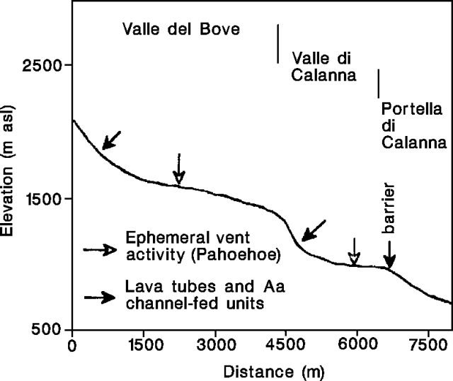 |
Figure 51. Profiles of the N, S, E, and W flanks of Etna. Courtesy of J. W. Hughes and M. Bulmer. |
References. Cumin, G., 1954, L'eruzione laterale del Novembre 1950-Dicembre 1951: BV, v. 15, p. 3-70.
Fouque, F., 1865, Sur l'eruption de l'Etna du 1st Fevrier 1865: C. Rend. Acad. Sci. Paris; v. 60, p. 1331-1334; and v. 61, p. 210-212.
Frazzetta, G., and Romano, R., 1984, The 1983 Etna eruption: event chronology and morphological evolution of the flows: BV, v. 47, p. 1079-1096.
Hughes, J.W., 1992, The Influence of volcanic systems on the morphological evolution of lava flow fields: Ph.D. dissertation, University of London, 255 p.
Pinkerton, H., and Sparks, R.S.J., 1976, The subterminal lavas, Mount Etna: a case history of the formation of a compound lava flow field: JVGR, v. 1, p. 167-182.
Geological Summary. Mount Etna, towering above Catania on the island of Sicily, has one of the world's longest documented records of volcanism, dating back to 1500 BCE. Historical lava flows of basaltic composition cover much of the surface of this massive volcano, whose edifice is the highest and most voluminous in Italy. The Mongibello stratovolcano, truncated by several small calderas, was constructed during the late Pleistocene and Holocene over an older shield volcano. The most prominent morphological feature of Etna is the Valle del Bove, a 5 x 10 km caldera open to the east. Two styles of eruptive activity typically occur, sometimes simultaneously. Persistent explosive eruptions, sometimes with minor lava emissions, take place from one or more summit craters. Flank vents, typically with higher effusion rates, are less frequently active and originate from fissures that open progressively downward from near the summit (usually accompanied by Strombolian eruptions at the upper end). Cinder cones are commonly constructed over the vents of lower-flank lava flows. Lava flows extend to the foot of the volcano on all sides and have reached the sea over a broad area on the SE flank.
Information Contacts: F. Barberi, Univ di Pisa; L. Villari, IIV; R. Romano and T. Caltabiano, IIV; P. Carveni, M. Grasso, and C. Monaco, Univ di Catania; W. McGuire and A. Morrell, Cheltenham and Gloucester College of Higher Education; S. Saunders, West London Institute; D. Rothery, A. Borgia, R. Carlton, and C. Oppenheimer, Open Univ; J. Wyn Hughes and M. Bulmer, Univ College London.