Report on Shasta (United States) — June 1992
Bulletin of the Global Volcanism Network, vol. 17, no. 6 (June 1992)
Managing Editor: Lindsay McClelland.
Shasta (United States) No seismicity triggered by M 7.5 earthquake hundreds of kilometers away
Please cite this report as:
Global Volcanism Program, 1992. Report on Shasta (United States) (McClelland, L., ed.). Bulletin of the Global Volcanism Network, 17:6. Smithsonian Institution. https://doi.org/10.5479/si.GVP.BGVN199206-323010
Shasta
United States
41.409°N, 122.193°W; summit elev. 4317 m
All times are local (unless otherwise noted)
Southern California's largest earthquake since 1952, M 7.5 on 28 June, appeared to trigger seismicity at several volcanic centers in California. It was centered roughly 200 km E of Los Angeles. In the following, David Hill describes post-earthquake activity at Long Valley caldera, and Stephen Walter discusses the USGS's seismic network, and the changes it detected at Lassen, Shasta, Medicine Lake, and the Geysers.
In recent years, the USGS northern California seismic network has relied upon Real-Time Processors (RTPs) to detect, record, and locate earthquakes. However, a film recorder (develocorder) collects data from 18 stations in volcanic areas, primarily to detect long-period earthquakes missed by RTPs. The film recorders proved useful in counting the post-M 7.5 earthquakes, most of which were too small to trigger the RTPs.
The film record was scanned for the 24 hours after the M 7.5 earthquake, noting the average coda duration for each identified event. Some events may have been missed because of seismogram saturation by the M 7.5 earthquake. Marked increases in microseismicity were observed at Lassen Peak, Medicine Lake caldera, and the Geysers (table 1). No earthquakes were observed at Shasta, but the lack of operating stations on the volcano limited the capability to observe small events.
Table 1. Number of earthquakes at northern California volcanic centers during 24-hour periods following major earthquakes on 25 April (40.37°N, 124.32°W; M 7.0) and 28 June (34.18°N, 116.47°W; M 7.5) 1992. Events with coda durations less than or equal to 10 seconds and greater than 10 seconds are tallied separately. Earthquakes were identified from film records of seismograms from nearby stations. Courtesy of Stephen Walter.
| Date | Lassen | Shasta | Medicine Lake | Geysers | ||||
| Codas (seconds) | <= 10 | > 10 | <= 10 | > 10 | <= 10 | > 10 | <= 10 | > 10 |
| 25 Apr 1992 | 0 | 0 | 0 | 1 | 0 | 0 | 7 | 2 |
| 28 Jun 1992 | 8 | 14 | 1 | 5 | 12 | 0 | 46 | 4 |
Film was also scanned for the 24 hours following the M 7.0 earthquake at 40.37°N, 124.32°W (near Cape Mendocino) on 25 April. Although smaller than the 28 June earthquake, its epicenter was only 20-25% as far from the volcanoes. Furthermore, both the 25 April main shock and a M 6.5 aftershock were felt at the volcanic centers, but no felt reports were received from these areas after the 28 June earthquake. Only the Geysers showed any possible triggered events after the 25 April shock. However, background seismicity at the Geysers is higher than at the other centers, and is influenced by fluid injection and withdrawal associated with intensive geothermal development.
Shasta report. The film record showed no earthquake activity beneath Shasta (~900 km NNW of the epicenter), although telemetry problems limited the ability to detect events below M 2. Of the six earthquakes in the 24 hours following the M 7.5 shock, two were large enough to be recorded by the RTP system. These were centered about 60 km SE of Shasta and about equidistant from Lassen (figure 1). Because the arrival times and S-P sequences of the other four events were similar to those of the two located shocks, it is likely that all had similar epicenters. Occasional M 2 earthquakes have previously occurred in this area, which includes several mapped N-trending normal faults with Quaternary movement. Three days after the M 7.5 earthquake, a M 2.0 shock occurred beneath Shasta's SE flank, followed by a M 2.7 event the next day. Both were centered at about 15 km depth, similar to most earthquakes beneath Shasta in the last decade.
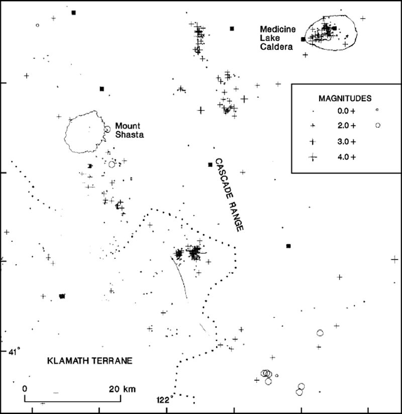 |
Figure 1. Seismic events in the Shasta/Medicine Lake area that were apparently triggered by the M 7.5 southern California earthquake of 28 June 1992 (circles) compared to 1978-90 seismicity in the region (crosses). Squares mark seismic stations. Courtesy of Stephen Walter. |
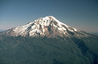
Geological Summary. The most voluminous of the Cascade volcanoes, northern California's Mount Shasta is a massive compound stratovolcano composed of at least four main edifices constructed over a period of at least 590,000 years. An older edifice was destroyed by a large debris avalanche which filled the Shasta River valley to the NW. The Hotlum cone, forming the present summit, the Shastina lava dome complex, and the SW flank Black Butte lava dome, were constructed during the early Holocene. Eruptions from these vents have produced pyroclastic flows and mudflows that affected areas as far as 20 km from the summit. Eruptions from Hotlum cone continued throughout the Holocene.
Information Contacts: Stephen Walter and David Hill, MS 977, U.S. Geological Survey, 345 Middlefield Road, Menlo Park, California 94025 USA.