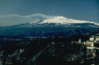
Report on Etna (Italy) — July 1992
Bulletin of the Global Volcanism Network, vol. 17, no. 7 (July 1992)
Managing Editor: Lindsay McClelland.
Etna (Italy) Continued lava production from SE-flank fissure; lava diversion summarized
Please cite this report as:
Global Volcanism Program, 1992. Report on Etna (Italy) (McClelland, L., ed.). Bulletin of the Global Volcanism Network, 17:7. Smithsonian Institution. https://doi.org/10.5479/si.GVP.BGVN199207-211060
Etna
Italy
37.748°N, 14.999°E; summit elev. 3357 m
All times are local (unless otherwise noted)
The following, from R. Romano, describes activity from early July through early August.
Early July-early August activity. The eruption ... was continuing after ~ 8 months. Gas emission from the upper part of the fissure has greatly diminished lately, although abundant white vapor was often observed, probably because of weather conditions. Fieldwork on 5 August revealed no notable changes in effusive activity from previous months. The lava flow was visible through a skylight at the beginning of the main lava channel (at 2,205 m asl) and through two smaller skylights at 2,100 m altitude. From there to ~ 1,800 m, lava flowed through a complex system of tubes, resurfacing from numerous ephemeral vents that varied in number (generally about 10) and location (mainly in the center of the lava field). From these ephemeral vents (all between 1,800 and 1,700 m elevation) very modest lava flows emerged. These advanced a few hundred meters at most, never moved past 1,600 m altitude, and remained within the pre-existing lava field. The total volume of lava produced by 234 days of activity was estimated at 170 x 106 m3.
No significant changes were observed at the central craters, where gas emission continued. The more active vent in early August was at the W crater (Bocca Nuova). Northeast Crater has remained obstructed for a few months, with only weak fumarolic activity on the inner walls. Internal collapses continued to occur. Gas emission from Southeast Crater was unchanged.
Seismic activity was low, with only 22 recorded events from early July through early August. The majority of the seismicity was characterized by swarm sequences in the summit area. The most significant, on 11 August, consisted of four shocks with a maximum magnitude of 2.5. Harmonic tremor was of very low energy and showed no variation over time.
The following is from a report by L. Villari.
Civil Protection problems and lava diversion. An earthen barrier was erected at the E end of Val Calanna by the beginning of January 1992, to prevent or delay the advance of lava into a narrow valley leading directly to the nearby (~ 2 km downslope) village of Zafferana Etnea (17:02). Lava expanded into the large Val Calanna basin in February and March, and began to accumulate against the inner wall of the barrier on 14 March. By the end of the month, lava almost completely filled the Val Calanna basin and rose slowly up the barrier's inner wall. Several lobes successively reached the barrier, and the lava field progressively grew and thickened, reaching the barrier rim by 7 April. Lava first overflowed the barrier, along its N sector, during the evening of 8 April, quickly followed by other lobes along the S and central part of the barrier's rim. Lava covered ~ 1 km during the first few hours, merging downslope into a single stream that advanced quickly toward the village. The flow's confinement in a narrow valley favored more rapid progress downslope. Three minor earthen barriers were rapidly constructed along the valley (10-11 April, 830 m asl, 110 m long, 12 m high; 11-12 April, 810 m asl, 90 m long, 6 m high; 13-14 April, 770 m asl, 160 m long, 12 m high) to slow the advancing flow. The barriers were built, like the major one at the E end of Val Calanna, by digging the valley bottom in front of the advancing flow and accumulating the loose material on a small natural scarp. Because the valley is narrow, the confined basins were only able to contain small volumes of lava, and the flow's advance was only briefly delayed (for hours to a day). The front reached <1 km from Zafferana (at Piano dell'Acqua) on 16 April, ~1.5 km from the major barrier and 8 km from the eruptive fissure (figure 53).
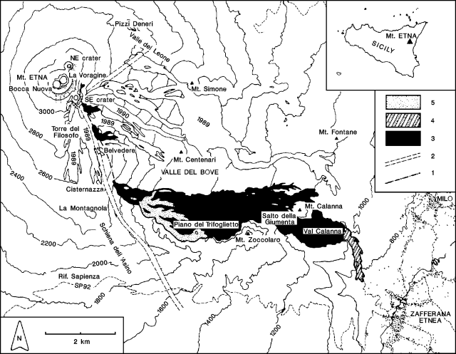 |
Figure 53. Sketch map of the 1991-92 lava field at Etna. 1. 1991-92 eruptive fissure; 2. 1989 fracture system; 3. 1991-92 lava flows; 4. lava flows downslope from the barrier at the E end of Val Calanna; 5. lava flows fed by the diversion. Dots mark individual houses in the Zafferana and Milo areas. Courtesy of L. Villari. |
At that time, morphologic conditions prevented any other local intervention to slow the lava advance. The creation of any possible artificial obstacle to the advancing front would divert the flow toward inhabited areas not necessarily threatened by the natural flow path. Diversion efforts were therefore concentrated far upslope, near the eruptive vent.
Attention was primarily on a skylight in the main lava tube at ~ 2,000 m altitude on the W wall of the Valle del Bove, a few hundred meters from the active vent. The diversion's early focus was blockage of the main tube carrying lava to the active front, by sliding solid rocks and concrete blocks into the flowing lava. Access problems required transport of solid materials to the site by helicopter, to be directly unloaded into the lava stream, or accumulated around the skylight's rim for later use. Lava tube blockage was also assisted by blasting large volumes of solid lava and welded scoriae forming the flow levees. This was partially successful and contributed to slowing the advance of the active front by several days.
Despite these efforts, on 5 May, a major new flow emerged from Val Calanna atop the 10 April flow, reaching Piano dell'Acqua on 11 May, 120 m beyond the 16 April flow and ~ 500 m from the outskirts of Zafferana. On 22 May, a further attempt to divert lava from the main natural tube to an artificially excavated channel high in the Valle del Bove produced a vigorous lobe that traveled 1 km in a few hours. Only 1/3 of the lava was spilled into the artificial channel, and the new flow roofed over within two days, with a significant loss of supply from the main natural flow.
A four-phase intervention plan was then defined (figure 54): a) digging an artificial channel to drain the main natural tube; b) cutting the lateral tube wall to a minimum thickness (2-3 m) that could be blasted through with a single charge; c) blasting the lateral wall; d) blocking the natural tube to divert all of the lava into the artificial channel.
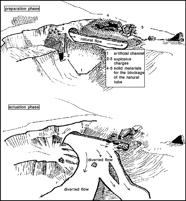 |
Figure 54. Sketch of the lava diversion carried out at Etna, 27 May 1992. Courtesy of L. Villari. |
Phases a and b were accomplished in about a week. A 7-ton charge, set off in a single explosion on 27 May at 1636, opened a large breach in the natural tube and caused spillage of ~ 80% of the flowing lava. The natural tube was progressively blocked by sliding solid materials into it during the next two days, and the flow was totally diverted into the artificial channel by 29 May. The artificially channeled flow went down the W slope of the Valle del Bove and remained confined inside the valley. The diversion effort stopped the most advanced front that had been moving toward Zafferana, by removing its source of supply.
The artificially channeled lava flow had extended to 1,550 m asl in the S part of the Valle del Bove (at Piano del Trifoglietto) by 30 May. Lava output from the ephemeral vents in Val Calanna quickly decreased, and molten lava was not evident within a few days.
The effusion rate from the eruptive fissure decreased sharply 31 May-1 June, causing the active flow front to be confined within the Valle del Bove, as activity resumed in the central craters. Several hours of continuous ash emission occurred from the W crater (Bocca Nuova) on 31 May, and an incandescent blowhole formed in the E crater (La Voragine) following gas blasts on 1 June. Noisy gas emission continued from La Voragine in succeeding days.
During June, lava flowing in the artificial channel expanded within the Valle del Bove to ~ 1,650 m elevation, overlapping the lava field that had formed since January. The effusion rate was reduced ~ 50% by the end of June, and the upper part of the artificial channel became a tube. The longest flow did not extend more than 1.5 km from the diversion point at 2,000 m altitude. At the end of June, the newly generated lava field, overlapping the old one, covered ~ 0.8 km2.
Northeast Crater. Repeated inner-wall collapses have been observed in Northeast Crater since February. They became quasi-continuous from 26 February through mid-March, associated with explosive activity that ejected blocks and caused a little fine reddish ashfall. From the end of March until 23 May, the collapses were limited to episodes lasting only several hours each, associated with only minor fine ashfall. The crater bottom dropped ~70 m, leaving a pit ~100 m across in place of the previous funnel-shaped depression.
Lava flow measurements. Lava-channel dimensions, flow velocity, and related rheological parameters were observed at a skylight along the lava tube at 2,000 m altitude, and at ephemeral vents in the Val Calanna area, 7 km downstream at 1,000 m elevation. Flow velocities at the exit of the lava tube (~ 4-5 m wide and 5 m deep) in May and the beginning of June were 0.5-1 m/s; flow rates and viscosities were 15-25 m3/s and 100-300 Pas. At the ephemeral vents and the single-channeled flows (1-4 m wide and 1-2.5 m deep), March-May flow velocities were 0.1-0.3 m/s. The calculated flow rate ranged from 0.1 to 4 m3/s, with a corresponding viscosity of 150-1,300 Pas. (See the report by Murray, below, for velocities and flow rates from late June through mid-July).
Direct measurements in June along the main channel (10-40 cm below the lava surface) at 2,000 m altitude, using an immersion thermocouple (Pt-PtRh) yielded temperatures of 1,053-1,068°C. Values were similar (1,030-1,068°C) at several ephemeral vents (10-60 cm inside the lava flow) in the Val Calanna area from March until the end of May.
Petrography and chemistry. Analysis of lava sampled near the vent and at the flow fronts showed no significant variations in chemical or petrologic composition (17:02). All are porphyritic hawaiites (Mg## 52-54), with phenocrysts of plagioclase (15-25 volume %), clinopyroxene (7-10%), olivine (2-3%) and minor (~ 1%) Ti-magnetite.
Seismicity. Low-level seismic activity characterized February-June, despite the continuing eruption. The daily rate was quite low, with only 24 fault-derived earthquakes of M >1 recorded during the period, a rather low value for Etna. No variations were evident in the daily rate or the cumulative strain release (figure 55). Most of the recorded shocks were centered on the SE flank. Maximum local magnitude was 2.8. There were no significant changes in the pattern of volcanic tremor amplitude. Two short episodes of increasing amplitude, on 31 May and 1 June, had maximum overall amplitudes slightly lower than during the December 1991 eruptive phase.
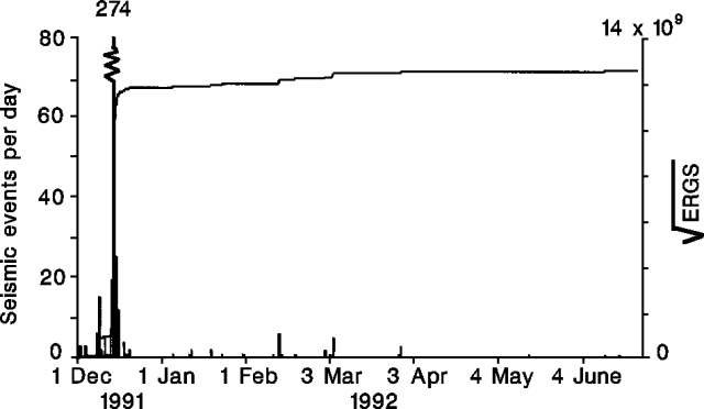 |
Figure 55. Daily number of seismic events (M >1) and cumulative seismic strain release recorded at Etna, December 1991-June 1992. Courtesy of L. Villari. |
From 26 February until May, seismic stations on the upper flanks recorded many shocks characterized by an emergent onset and low frequency content. At least three waveform types were recognized. All of the shocks were located near the summit craters at <1 km depth. At the same time, morphologic changes were noted within Northeast Crater, associated with the emission of non-juvenile tephra. Most of these shocks were believed to be linked to rockfalls within Northeast Crater. Some explosion shocks were recorded during the same period. These phenomena were most common in February and March, then gradually decreased, disappearing entirely by 23 May.
Ground deformation. Continuous monitoring of ground tilt in a shallow borehole network showed only minor variations since the eruption began in December 1991. No sign of the expected deflation of the volcano was noted, despite the large volume of magma that has been erupted.
EDM networks on the S, SW, and NE flanks, previously surveyed in 1991, several months before the eruption began, were re-measured in late spring and early summer. Contraction was observed, mostly on the SW and NE flanks, while the S flank did not show any appreciable change in line length. The overall deformation pattern of the volcano appears consistent with shallow magma injection into the eruptive fissure, trending roughly NNW-SSE (figure 56). GPS surveys in April-May 1992 detected significant contraction of lines, mostly on the W flank, compared to previous surveys in June-July 1991 (figure 57).
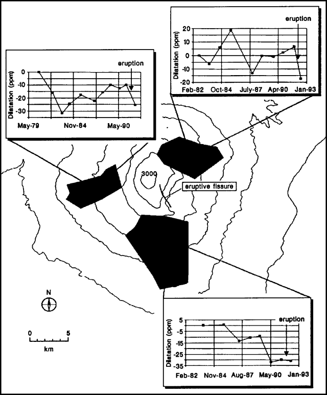 |
Figure 56. Cumulative areal dilation measured at 3 EDM networks on the flanks of Etna, 1981-92. Courtesy of L. Villari. |
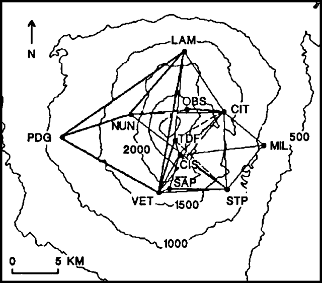 |
Figure 57. Variations in slope distance between GPS measurements at Etna in 1991 and 1992. Heavy lines show contraction, dashed lines show extension. Courtesy of L. Villari. |
The following, from J.B. Murray, describes eruptive activity and the results of deformation studies, 9 June-14 July.
Lava flows. The rate of lava production from the vent in the W wall of the Valle del Bove was much lower than in April. Active flows were visited on 28 June, and 7, 10, 12, and 13 July. Central flow speeds of 2-10 m/minute (depending on slope), widths of 1.5-6 m, and a rate estimated at around 0.3-0.4 m3/s were noted at a single flow on 28 June. A flow about twice as big was seen to the E, suggesting a total discharge of the order of 1 m3/s. Flow fronts were only advancing to ~ 1.2 km from the vent on 28 June, but discharge seemed slightly increased during July visits to the fronts, which were about 2.2 km from the vent on 7 July, and 2.6 km by 13 July.
Summit activity. Continued collapse was occurring around the edge of Northeast Crater, with rockfalls every few minutes or so. Particularly big collapses were seen on 8 July between 1556 and 1610. Southeast Crater had strong high-temperature fumaroles, but no Strombolian activity.
The floors of the two central craters both had single vents that continuously discharged hot gas without any explosions. The vent in La Voragine was ~3 x 10 m, glowed bright red in daylight, and beginning 10 June emitted gas in voluminous puffs from which radiant heat could be felt. There were no signs of fresh bombs or scoriae around the vent. The depth of Bocca Nuova was estimated at ~160 ± 20 m.
Vertical movement. A 25-km levelling traverse, and heights derived from trigonometric levelling during trilateration, yielded details of vertical displacement of 241 stations across the summit and upper flanks since September 1991. Subsidence occurred along a narrow strip extending SSE from the summit, with maximum movements reaching just over 1 m (at two stations between Cisternazza and Belvedere). This central strip is flanked by a swelling to the W of 3-7 cm, and a much larger swelling to the E that reaches 37 cm (at Serra Giannicola Piccola). Southeast Crater has dropped 87 cm and Northeast Crater 48 cm, and the NE rift has risen another 3.4 cm (near Monte Pizzillo). These movements are similar to displacements seen over eruptive dikes in 1989, 1986, 1985, and 1983, but the swelling to the E is higher and broader than any previously recorded.
Horizontal movement. The summit trilateration network shows E-W extensions of 1-1.5 m since September 1991 across the graben and fissures leading S to the eruption site. It is clear that the main feeder dike passes between the Torre del Filosofo and Belvedere, and probably crosses into the Valle del Bove just E of Cisternazza (figure 53). Movements of this magnitude are not unusual during Etna's flank eruptions, and are similar to those recorded during the four eruptions mentioned above.
After network adjustment, some individual station vectors showed unexpected movements. Many of the stations E of the summit also show large eastward displacements, with two (near the Serra Giannicola Piccola) showing 1.3 m of eastward movement, and much of the Valle del Leone having moved 0.5 m ENE. The region at the top of the valley's E wall is cut by new N-S fissures, and SE of Southeast Crater is a region of complex fissuring N of a new cinder cone.
Dry-tilt data. Results from the 30 dry-tilt stations confirm that this eruption is a major one among recent eruptions. In addition to the expected large tilts near the eruptive fissures (192 µrad near Cisternazza), unusually large post-September 1991 tilts of 115 and 92 µrad occurred ~ 4 and 5 km SW of the summit (at Monte Palestra and Monte Vituddi). Unexpectedly large tilts were also recorded ~ 7 km NW and 4.5 km WNW of the summit (at Monte Maletto and Monte Nunziata), and both the Punta Lucia and Pizzi Deneri stations have abruptly increased their tilt to the E, as after the 1981 eruption.
The observed dry tilts are exceptional and suggest that something fairly fundamental has occurred. Only the 1981 eruption had tilts of this size at distant stations. That eruption marked a major turning point in Etna's deformation. After 1981, five stations that had previously been stable, even during flank eruptions, tilted during the next few years by amounts that eventually totalled as much as 1,000 µrad.
Geological Summary. Mount Etna, towering above Catania on the island of Sicily, has one of the world's longest documented records of volcanism, dating back to 1500 BCE. Historical lava flows of basaltic composition cover much of the surface of this massive volcano, whose edifice is the highest and most voluminous in Italy. The Mongibello stratovolcano, truncated by several small calderas, was constructed during the late Pleistocene and Holocene over an older shield volcano. The most prominent morphological feature of Etna is the Valle del Bove, a 5 x 10 km caldera open to the east. Two styles of eruptive activity typically occur, sometimes simultaneously. Persistent explosive eruptions, sometimes with minor lava emissions, take place from one or more summit craters. Flank vents, typically with higher effusion rates, are less frequently active and originate from fissures that open progressively downward from near the summit (usually accompanied by Strombolian eruptions at the upper end). Cinder cones are commonly constructed over the vents of lower-flank lava flows. Lava flows extend to the foot of the volcano on all sides and have reached the sea over a broad area on the SE flank.
Information Contacts: L. Villari, R. Romano, and T. Caltabiano, IIV; P. Carveni, M. Grasso, and C. Monaco, Univ di Catania; G. Luongo, OV; J. Murray, Open Univ.