Report on Copahue (Chile-Argentina) — July 1992

Bulletin of the Global Volcanism Network, vol. 17, no. 7 (July 1992)
Managing Editor: Lindsay McClelland.
Copahue (Chile-Argentina) Small explosions and mudflows; strong sulfur odors
Please cite this report as:
Global Volcanism Program, 1992. Report on Copahue (Chile-Argentina) (McClelland, L., ed.). Bulletin of the Global Volcanism Network, 17:7. Smithsonian Institution. https://doi.org/10.5479/si.GVP.BGVN199207-357090
Copahue
Chile-Argentina
37.856°S, 71.183°W; summit elev. 2953 m
All times are local (unless otherwise noted)
A series of explosions started [at Copahue (figure 1)] on 31 July at about 0900 and continued until 1133 [all times are Chile local time]. Photographs taken 10 km NE of the volcano (at Los Copahues thermal springs, Argentina) show small, cauliflower-shaped columns emerging from the E (Del Agrio) crater. Ash clouds were rapidly dispersed by SW winds, and a strong sulfur smell was noted in the area. Renewed explosions began at around 1800 and continued until about 0300 the next morning, also producing ash columns and a sulfur smell. Earthquakes had begun to be felt in the area on 30 July.
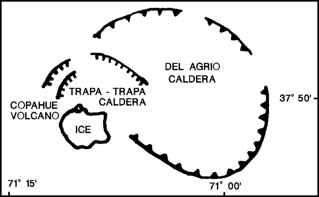 |
Figure 1. Schematic view of the Copahue complex, showing the position of the historically active summit crater with respect to the Del Agrio and Trapa-Trapa calderas. Adapted from a map by O. González-Ferrán. |
Hugo Moreno overflew the summit on 1 August at 1700. Solfataric activity was intense in the E crater, and snow had melted on the inner crater walls and rim. Pyroclastic-fall deposits covered ~ 1.5 km2 of the upper NE flank, and light ashfall extended 4-5 km NE. The bottom of the active crater had previously been filled by a green, highly sulfuric, acid lake (pH about 1.5), which appeared to be covered by a grayish, cracked ash blanket. Small debris-flow deposits could be seen for 3-4 km along Del Agrio stream, which drains the crater lake through a small notch in the E rim.
An explosion occurred on 2 August at 0330, and fine lapilli-fall (2-16 mm diameter) was reported 30 minutes later at Caviahue village, 15 km SE of the volcano, where hotels were filled with tourists. Small phreatic explosions occurred at 15-minute intervals during the morning. Field observations by Daniel Delpino revealed that lapilli-sized pumice to 7 mm in diameter had fallen on the volcano's snow-covered flanks. About 90% of the ejecta were accessory fragments, including rounded sulfur-rich vesicular particles. Only ~ 10% were believed to be juvenile. Four small debris flows were identified, one toward the E (Del Agrio stream), the other three toward the S (into Chile). These coalesced into one flow that turned SW along the Lomín river, which flows into one of Chile's major rivers, the Bíobío. The debris-flow deposits were a mixture of snow, ice, and pyroclastic material up to 1 m deep. Earthquakes were felt for the first time at Caviahue on 2 August between 2230 and 2245, when three had intensities of about MM II-III. An intense sulfur smell was noted throughout the area within the Del Agrio caldera that contains Caviahue and several lakes.
Some of the 300 tourists at a hotel in Caviahue suffered from headaches, and they were advised to leave the area. A 20-km restricted zone around the volcano was recommended by Hugo Moreno. Additional visitors were prevented from entering the Caviahue area. There are few towns near the volcano in Chile. Guallalí is 20 km SW and Trapatrapa is 17 km NW, but many houses and small settlements are distributed along the Lomín/Bíobío and Queco rivers. The Chilean electricity enterprise (ENDESA) was warned of potential hazards because the Pangue and Ralco hydroelectric projects have camps along the Bíobío river, 45 and 35 km from the volcano, respectively.
Univ de la Frontera seismologists installed two MEQ-800 seismic stations at the E foot of the volcano on 5 August, one 9 km from the active crater (near Caviahue), the other 18 km away (in Cajón Chico). During the first 8 hours, 150 harmonic tremor events were recorded (figure 2), with frequencies of 0.9-1.3 Hz. The next day, 815 events were recorded, including a 2.5-minute long-period earthquake at 1858 associated with a phreatomagmatic explosion that generated a mushroom-shaped column 700 m high. Strong winds rapidly carried the column NE, leaving a dark-gray deposit on the recent NE-flank snowfall. No eruptive activity had been reported since the 2 August explosion, but bad weather had obscured the volcano until 30 minutes before the 6 August ash ejection.
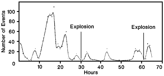 |
Figure 2. Number of tremor episodes per hour recorded by a seismic station (Caviahue), 9 km from the active crater at Copahue, 5-9 August 1992. Courtesy of the SAVO seismological team. |
Daniel Delpino, Luís Mas, and Hugo Moreno overflew the volcano by helicopter during the late morning of 7 August. An elliptical airfall deposit 11 km long and 2 km wide covered the NE flank. Several secondary, gravitationally generated, flows had occurred on steep unstable talus slopes near the crater. Ballistic blocks had produced numerous impact craters to ~ 1 m in diameter in this area. Moderate fumarolic activity was occurring in the crater. S of the v-shaped notch in the crater rim, very narrow red-brownish mudflows, probably overflows of muddy crater-lake water, extended no more than 150 m. The geologists landed ~ 2.5 km NE of the crater near the tephra-dispersion axis. The dominant airfall material was accretionary lapilli 0.3-1 cm in diameter, composed of very fine sulfur-rich dust spherulites. Most of the remainder of the deposit was also accessory material, including angular volcanic lithic fragments up to 3 cm across. Small globular to ribbon-shaped vesicular glassy fragments were also found, and were interpreted as juvenile hydroclastites. A new, less-voluminous debris-flow deposit had been emplaced along the Del Agrio stream, on top of the earlier deposit. Pale-brown muddy material extended about 200 m beyond the previous flow front, ~ 4.2 km from the crater. Another overflight late on 8 August showed small fumaroles in Del Agrio crater, but no other visible activity within the 2-km-long, ENE-WSW row of summit craters, or elsewhere outside of the Termas de Copahue area.
Seismicity declined after the 6 August explosion, remaining at low levels until tremor began to increase on 9 August at 0230. Between 0330 and 1230, 176 episodes of harmonic tremor were recorded, and 5 high-frequency events were detected during the same period. A 2.9-minute long-period earthquake occurred at 1057, probably marking a phreatic or phreatomagmatic explosion. However, the volcano was obscured by weather clouds, and the explosion could not be confirmed.
O. González-Ferrán visited the volcano on 12-13 August, with the support of the Chilean Air Force. The source of the explosions was a new vent, 100 m in diameter at the rim and 30 m across at the base, on the outer SW flank of the active crater (figure 3). Ash deposits evident during his fieldwork extended ENE and SE, to maximum distances of 4 and 6 km, respectively. Partial melting of the glacier, 5-40 m thick, that covers the older inactive summit craters and the SSW flank, had generated at least three jökulhlaups and a small lahar that extended ~ 6 km down the S flank toward the Lomín/Bíobío river system. An ~ 60-m-long fracture (f on figure 3) below the outflow of the crater lake was the source of another small mudflow that descended the Del Agrio river toward Del Agrio lake. The crater lake, ~ 300 m in diameter with 5-6 x 10⁵ m3 of acid water, continues to drain to the E at 2,716 m altitude. Lake level had dropped 8-10 m since the previous visit by González-Ferrán in 1990. Solfataras were active on the crater's S interior wall, and fresh landslides were visible on the SE interior wall. The glacier's headwall, 30-50 m high, is 80 m above the lake, and is the lake's main source of water.
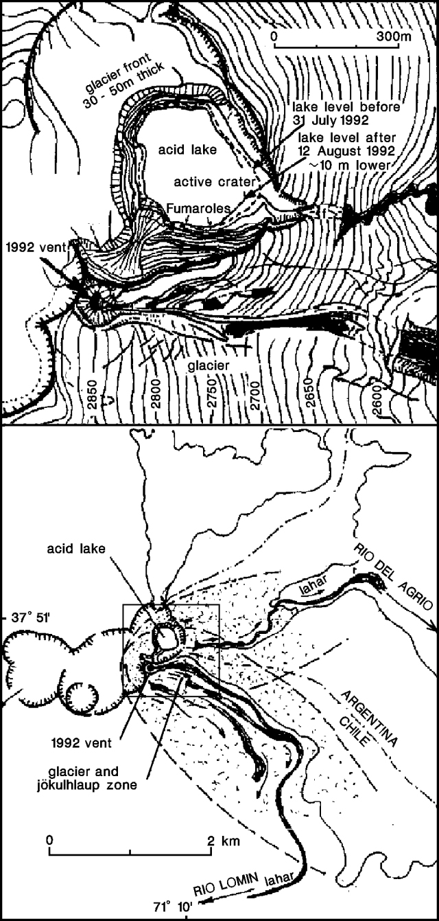 |
Figure 3. Sketch of the summit area (top) and locations of 1992 eruption deposits (bottom) at Copahue, 13 August 1992. The 60-m fracture that spawned a small mudflow in the Del Agrio river is marked with an "f". The approximate area shown by the summit-area sketch is enclosed by a box on the bottom drawing. Courtesy of O. González-Ferrán. |
Small earthquakes at 3.7 and 6.3 km depth were recorded at 0222 and 0226 on 14 August. A light-gray gas cloud extending 10 km SE from Del Agrio crater was seen at 0700. Daniel Delpino, Alberto Andolino, and Mario Deza reported strong effervescence and waves on the crater lake, which also showed strong fumarolic activity, at 1500. An explosion signal lasting 10 seconds was recorded at 1731. Four minutes later, a dense, light-gray gas cloud with dimensions of about 2 x 0.6 x 0.5 km descended ~ 4 km ESE, remaining there until about 0615 the next morning. A series of explosions and a strong increase in tremor, to 30-40 episodes/hour, began at 2100 on 14 August. During the night, the entire volcano was covered by a gaseous fog. Tremor activity was lower on 15 August, with about 20-25 episodes per hour between 0700 and 1700. Earthquakes were recorded at Caviahue at 0538, 0558, and 0645.
Geological Summary. Volcán Copahue is an elongated composite cone constructed along the Chile-Argentina border within the 6.5 x 8.5 km wide Trapa-Trapa caldera that formed between 0.6 and 0.4 million years ago near the NW margin of the 20 x 15 km Pliocene Caviahue (Del Agrio) caldera. The eastern summit crater, part of a 2-km-long, ENE-WSW line of nine craters, contains a briny, acidic 300-m-wide crater lake (also referred to as El Agrio or Del Agrio) and displays intense fumarolic activity. Acidic hot springs occur below the eastern outlet of the crater lake, contributing to the acidity of the Río Agrio, and another geothermal zone is located within Caviahue caldera about 7 km NE of the summit. Infrequent mild-to-moderate explosive eruptions have been recorded since the 18th century. Twentieth-century eruptions from the crater lake have ejected pyroclastic rocks and chilled liquid sulfur fragments.
Information Contacts: D. Delpino, A. Bermudez, and M. Pérez, Dirección Provincial de Minería, Zapala, Argentina; H. Moreno, SERNAGEOMIN-SAVO, Temuco, Chile; G. Fuentealba and J. Cayupi, SAVO-Univ de la Frontera, Temuco, Chile; Oscar González-Ferrán, Univ de Chile.